The Talon 2007
This was one of those races that could only be described with a wow. Jim Hartnett was trying out a new format for the races that really allowed all teams to get the most out of the entire race. Their would be a mandatory course that all teams would complete and then after completion we would start on a Rogaine format course that would allow teams to accumulate points. The top teams were expected to be able to complete the course within 5-6 hours and then get another few hours of intense racing collecting the bonus checkpoint.
I was racing with long time race partner Greg Corbitt, we’ve raced together many times so are pretty used to each other on the course. Shortly after 7:30 AM we did a quick half mile run to spread the pack and started on the single track bike section. Greg and I placed ourselves well on the run and entered the single track as the third team – ensuring that we would not be stuck behind other teams. I was pacing well and Greg was in front of me as we went through River Loop, Rock Garden, and then the Sand Pine trails. These are nice single track sections and with the exception of Rock Garden relatively easy single track. We crossed over the power lines where Greg spaced me a bit and entered Roller Coaster. Roller Coaster has some solid drop and rollouts with steep slopes and rocks and turns making it a relatively tough course. Here I would have a spectacular crash, though I am not even sure what happened, breaking my map board and putting a slight bend in my back tire. Greg was ahead of me and did not hear the crash. As I sat up stunned, I did the usual broken bone check (OK), bleeding check (just some skin off my knee), and then checked my bike. My back tire was slightly bent and not rolling so I was either going to have a lot of fun with a chain tool, or I’d get lucky. Sure enough I got lucky and a hard smack on the tire popped it back into skew. I was now off again – though a lot more cautious and shaky this time. I walked a few rollers that would have been a lot of fun to ride, still being shaky from the fall.
Luckily all this occurred real close to the transition area and as I came in Jim informed me that Greg was just in front of me on the “second loop”. I’m not quite sure what this loop entailed as when I got out on the course it looked like teams (which were somehow behind me) were pedaling both direction on all the trails. I took the trail that looked like the intended course and heard Greg’s voice ahead of me – who was coming towards me. Since we had all bike checkpoints we headed for the TA.
We had 2 small orienteering legs at the TA. We blasted through the first one and quickly caught up with the lead pack. On the second one we got to the final bearing (125 yards at 310 degrees) which took us up onto a large Gypsum piling that was being thoroughly searched by the lead pack. After 15-20 minutes of searching we headed back to the control that had the bearing to learn that the distance was off. (In reality it was more like 75 yards at 320 degrees). This served to flip the pack – the earlier lead teams (who spent a lot of time searching) were now behind as we biked to the canoes.
The paddle started south where we had some open water paddling eventually ending up in a narrow channel (think bumper boats) and CP10. We turned around (more bumper boats) and headed back to the canoe launch. There we would climb up a cargo net to the bridge and down the other side on wood posts and start the second half of the paddle. Because the punch was attached to the boat and there was not much water in the “river” this leg turned out to be a boat drag for about 1 ½ miles (up and back). I was feeling really bad (still shaky from the crash and nauseous in this leg), and Greg came through by doing most of the dragging. I was hoping I would recover, as I was extremely weak and also nauseous at this point – which at the level of exertion we had been at (not high), did not make sense to me. We finally made it back to the canoe launch and biked back to the TA for the last mandatory leg of the race, the orienteering.
Alafia River State Park is lucky enough to have extremely high dirt piles left by the mining industry from years past. These pilings have now become completely canopied and grown in with ferns and other plant life. Going through these areas – you would think you were hiking the Appalachian Trail. It also makes for great orienteering as teams now had to scramble up steep slopes, travel ridge lines, and cross mucky streams at the base. Greg and I flew through this section and I also started recovering my energy at this time. As we returned to the TA to complete the mandatory course I was in great spirits.
The Rogaine started with pretty much all the lead teams within 30 minutes (we started right around 2 PM) of each other (every team had a pretty good chance of taking the race at this point). Our strategy was to go for the greatest point densities – which first meant completing the special tests. These went very quickly, and I got to even scale the pole which was the “ropes course”. We dropped our bikes near CP 24 and then easily found 24, 25, 26, and 23, with a little challenge on 25 as Greg had to scale a large tree to get to the punch. We returned to the bikes and then biked to near CP 32, swam across the muck pond and then back, and finally biked around to near CP 27 and did (in this order) 27, 28, 29, 30, and 31.
With about 2 hours of racing left I decided we would make a loop (for 8 points) and hit CP 36, 38, 37, and 39 (also in that order). We spent too much time on 36, originally overshooting it and then searching for the flag. CP 37 was a lot of fun as we crossed the fence and found the concrete bridge which required (me this time) a balancing act to get to the conduit chase about 20 feet away from the bridge where the flag was hung. The strategy was to do this south loop, head back to the TA, and if we had enough time hit CP 41 and 43. We arrive back at the TA with 15 minutes to spare – but I selected a bad attack point for CP 41 (too much hurrying) and we eventually had to head in. By my calculation we had 44 points that should put us well into the standings. My original plan would have given us 7 additional points (51 total) – but time did not allow that.
I transcribed the letters at the end, where I made an error transcribing CP31 (which for some reason sitting in front of me now is very clear), writing E instead of U. This dropped us from 44 points to 41 points and from 2nd to 6th in our division (bummer) and even though it was clear we had visited the CP, the race officials would not credit us the points (double bummer). However, I come to the races for the adventure and my wife won’t let me keep the trophies anyway (I’ve already had multiple trophy purges), so having my fill of adventure for the day I still left happy.
As always, It was great seeing all the teams – special thanks to Village Bike, Bill Jackson’s, Gecko, and Jim’s Bicycles who we spent a lot of the race with. It is always great to race alongside fun teams who also enjoy the adventure and the competition. And also a special kudo’s to Jim Hartnett who really found a winning formula in the race format. I was happy to get a full 10 hours of racing (in past years we finished in well under that and spent a lot of time sitting around for awards). And the best thanks to my team-mate Greg who pulled me through the rough time I had in this race.
Sunday, May 06, 2007


Tuesday, March 13, 2007
Squiggy Classic
The Squiggy Classic AR March 11, 2007
This was my first time doing the Squiggy classic and the fact it was on a Sunday allowed me to be able to make it to the race. I am very glad I did, as I was able to experience a wonderful race in a fantastic location. I raced this with team Are We There Yet – the classic team of Captain Will Murphy and a fairly new racer Gwilym – whom we now have christened as “G”.
From the starting line which was really just the parking area at Morris Bridge TA’s we were bussed to another location (John B. Starkey Park) where we were greeted by Kip Koelsch who basically counted down the race start and then threw the instructions in the air. We grabbed one set and were greeted by three relatively easy questions; (1) Name of the Squirrel who is mascot for the Wilderness Parks, (2) What is the term for the lines on a topographic map that define areas of similar elevation?, and (3) What is the name for a linear feature such as a trail, stream, road, or lakeshore that closely parallels your route and may be helpful in navigating? The questions were quickly solved and the using the letters of the answers we were able to get a set of bearings and distances to follow to retrieve 3 tokens.
We moved quickly to the first location and located the bucket which contained a “bead” which we pocketed and then started towards the second bearing and our first mistake. A mistake made by many of the experienced teams was to take the second set of bearing and distances from the location of the previous one – which unfortunately was wrong, we needed to return to the start location to head for the second set of bearings. I of course still think the instructions were vague (“Starting Point is the Iron Ranger next to the Please Donate Sign” – with no mention of “for each bearing”) Oh well!, after realizing our mistake after much unnecessary bushwhacking, we headed back to the central location and quickly located the other 2 buckets of tokens. Some teams had been able to turn our mistake (we weren’t the only ones though) into a 10 minute lead and had their boats in the water even before we realized our mistake. From the boats still on the ground – I estimated we were between the 50th and 60th team (of 70) to hit the water.
Once we did get our boat in the water – Will, G, and I moved into one of our strengths. Even though we were using a supplied canoe (not necessarily speedy) – three good paddlers with wing paddles can make a boat flat-out move. Combine that with our determination to make up most of the ground before the end of the paddle – we were hitting it hard. As we approached the first CP on the paddle I looked at the clue sheet and read the instructions, “Record the number of knots in the rope at PP1”. As we approached the checkpoint I could see the number of knots was three and said – “It’s 3, turn around”. This caused confusion and we were still paddling towards it. After a bit of explaining the team was all on board with the fact that the first 3 checkpoints were question and answer.
The remaining paddle was a session of hammering the water, passing boats, a little bit of bumper boats, and preventing ourselves from capsizing. I estimate we had our 16 foot fiberglass canoe up to a solid 6-7 mph on some straight-aways which made hitting the submerged logs pretty interesting. Though the boat had a couple of tips that put the edge within an inch of the water – we were not only capable of keeping it upright, most of the time we did not even break a beat in our paddling. We had resigned ourselves to the fact that if we tipped, we tipped and we would simply jump out, right the boat, and hop back in. We had even gotten to the point that we accelerated into some logs that were across our path – like we planned to bunny hop them in a boat, most of the time we would get across without the obstacle completely stopping us.
We had obviously done something right as we left the water in 11th place, and even though I had not counted the teams we passed – that did seem to make sense. We had a scare as we dropped one of our little beads from the earlier navigation and it disappeared down into the water – but the volunteer manning the CP saw it and let us through to the first special test. As I prepared the maps for the bike leg and changed shoes – Will and G tossed a turnip into a bucket and G retrieved it with his mouth. It took us all of 20 seconds to complete and we were in and out of the TA within the planned 3 minutes including the special test.
The next leg was a mountain bike leg and we got to see a few of the teams that were competing in the other race (the Squiggy Dash) and cheer them on as we biked in the opposite direction of where they were running. I was familiar with about the first half-mile of trails on the ride and I knew that teams in front of us probably had a high familiarity with the trail network in the area. We quickly got our legs under us and got into a biking rhythm. We did not make any navigation errors in the biking section, but I did need to spend time actually navigating. Three times we overshot the control and we overshot one turn, but never by more than 200 meters and we always quickly caught our mistake. Most of the navigation I was able to do while moving on the bike so I did not lose too much time to stopping to read the map. I really enjoyed this section of the course as it was all off-road biking and we only had one interruption for a special test that had us running up and down a hill with each piece of our required gear. My favorite control was the “hidden pond” that forced us off our bikes for a short distance and required us to use the map and read features to get to the control. We did probably lose about 5 minutes on this one searching – but mostly due to me relying on a blind bearing rather than map reading.
We came off the bike ride in 7th place, another jump – but except for two teams that had a good lead – this part of the pack was very tightly grouped with maybe a 10 minute spread between 5-6 teams – great racing! We were now in my element – foot navigation and we took off at a light trot. We made quick work of the first three checkpoints – and we used direct (rather than trail routes) for them. As we were heading for CP4, both Will and I agreed that we would be better off doing 4-7 in a different order – so we headed from 3 to 7 passing by the TA and a grinning Kip Koelsch who was watching us make a possibly race killing mistake. The passport stated that we needed to complete the CP’s in order and we were heading in the wrong direction and for an hour penalty as we bushwhacked towards CP7. We reached the trail which the checkpoint was along and for some reason I went totally brain dead and directed us to go along the trail the wrong direction and also for a long distance. We did catch our mistake and come back and find CP7 – but an easy control that would normally take 2 minutes had cost us an easy 10 minutes. I was resolved after that not to make any more mistakes and was puzzled at myself for making this one (had I lost that much concentration?). We started for CP6 doing the “backwards” thing when we ran along Team Flight heading towards CP7. Mike was puzzled to see me going the wrong direction and I was puzzled to see them just now completing orienteering section. I quickly calculated in my head the amount of time spent in small chunks navigating the bike section and our differential in speed (having raced along side Mike and his team I know they move much faster on bikes than we had) and had them at least 45 minutes ahead of us – which did not mesh with their current location.
Mike quickly explained how they had gotten into this location in the pack, they had done the course out of order and had been forced to redo control 4-7 or take an hour penalty. He also let me know that I was about to do the same. He gave me some hints (helpful) on the upcoming controls, and though I had nothing to offer, he knows I’ll return the favor in some upcoming race. This is (by the way) what adventure racing is all about. For those who wonder about helping out other teams – I have towed members of other teams, gone back and helped lost teams, stopped to render assistance many times and feel that this is what really makes a good adventure racer – more than just winning. I also have seen this in folks like Mike and his team and many other racers – and it is what makes me proud of this sport.
Anyway we were quickly back on track and hit CP4 – CP6. At CP6 we ran into an entire host of teams who were looking at the aerial map that had the location of the actual control. A quick glance and I knew the location and we headed off with a large group of teams. The funniest moment on this was when Jim from “Team Jim’s Bicycles” started crowing – which I guess was the signal they used to signal they had found the control. I simply yell – “Over Here! Found It”. Will was a bit tired at this point – but we were still able to keep a decent pace to CP7 and back to the TA as a large group of teams including Gecko and Jim’s Bikes all ran into the TA and we all took off together on bikes.
I’m glad most of the other teams have confidence in my navigation. We reached one point where a few trails headed off into different direction and I had to determine the correct trail. Many times when there are a lot of teams – the whole group slows down waiting for someone to take the navigation lead. This was not the case here, I directed Will through the trails somehow getting slightly off, but also quickly correcting and we picked up the last bike Checkpoint and started the sprint to the finish line. After leaving CP I we saw one team who we had biked with and ran with earlier heading back the opposite direction. We had no time for explanation – but I was willing to bet they had forgotten to visit CP I. Ouch!
Only one navigation decision remained – as we reached the river I stopped to confirm that we needed to head to the road and cross the river. Will had headed the wrong way so I biked after him to pull him back and some folks followed me. Other folks were at the intersection looking confused. As I came back to the intersection and headed down the correct trail I simply shouted to the other teams “This Way to the Road!” and we all hopped off our bikes as we got to the road and pushed them up the hill and over the guard rail. Will, G, and I were the first on our bikes with a large pack behind us. I was ready to sprint in to the finish, now less than ¼ mile of actual riding. We all came across the finish line within seconds of each other.
In the end we finished 5th, with 4th place going to Lenny (a solo racer) who crossed the finish line with us. We did win our division (3 person male) and I was very happy with our team performance. I had not navigated a perfect race (a very elusive thing) – but had navigated well. For those navigators out there, they will understand the compulsion. As soon as you finish any race – you are eager for the next one so you can avoid the mistakes you made last made looking for that perfect race. I think that is also the lure of golfing!
Thanks to WeCeFAR for a great race and a good time. I’ll be back for this one – and yes Mike I think you should set it, and I’m looking for a real navigation challenge! And special thanks to my team-mates Will and G - yes I do want to race with you again, it was great.
This was my first time doing the Squiggy classic and the fact it was on a Sunday allowed me to be able to make it to the race. I am very glad I did, as I was able to experience a wonderful race in a fantastic location. I raced this with team Are We There Yet – the classic team of Captain Will Murphy and a fairly new racer Gwilym – whom we now have christened as “G”.
From the starting line which was really just the parking area at Morris Bridge TA’s we were bussed to another location (John B. Starkey Park) where we were greeted by Kip Koelsch who basically counted down the race start and then threw the instructions in the air. We grabbed one set and were greeted by three relatively easy questions; (1) Name of the Squirrel who is mascot for the Wilderness Parks, (2) What is the term for the lines on a topographic map that define areas of similar elevation?, and (3) What is the name for a linear feature such as a trail, stream, road, or lakeshore that closely parallels your route and may be helpful in navigating? The questions were quickly solved and the using the letters of the answers we were able to get a set of bearings and distances to follow to retrieve 3 tokens.
We moved quickly to the first location and located the bucket which contained a “bead” which we pocketed and then started towards the second bearing and our first mistake. A mistake made by many of the experienced teams was to take the second set of bearing and distances from the location of the previous one – which unfortunately was wrong, we needed to return to the start location to head for the second set of bearings. I of course still think the instructions were vague (“Starting Point is the Iron Ranger next to the Please Donate Sign” – with no mention of “for each bearing”) Oh well!, after realizing our mistake after much unnecessary bushwhacking, we headed back to the central location and quickly located the other 2 buckets of tokens. Some teams had been able to turn our mistake (we weren’t the only ones though) into a 10 minute lead and had their boats in the water even before we realized our mistake. From the boats still on the ground – I estimated we were between the 50th and 60th team (of 70) to hit the water.
Once we did get our boat in the water – Will, G, and I moved into one of our strengths. Even though we were using a supplied canoe (not necessarily speedy) – three good paddlers with wing paddles can make a boat flat-out move. Combine that with our determination to make up most of the ground before the end of the paddle – we were hitting it hard. As we approached the first CP on the paddle I looked at the clue sheet and read the instructions, “Record the number of knots in the rope at PP1”. As we approached the checkpoint I could see the number of knots was three and said – “It’s 3, turn around”. This caused confusion and we were still paddling towards it. After a bit of explaining the team was all on board with the fact that the first 3 checkpoints were question and answer.
The remaining paddle was a session of hammering the water, passing boats, a little bit of bumper boats, and preventing ourselves from capsizing. I estimate we had our 16 foot fiberglass canoe up to a solid 6-7 mph on some straight-aways which made hitting the submerged logs pretty interesting. Though the boat had a couple of tips that put the edge within an inch of the water – we were not only capable of keeping it upright, most of the time we did not even break a beat in our paddling. We had resigned ourselves to the fact that if we tipped, we tipped and we would simply jump out, right the boat, and hop back in. We had even gotten to the point that we accelerated into some logs that were across our path – like we planned to bunny hop them in a boat, most of the time we would get across without the obstacle completely stopping us.
We had obviously done something right as we left the water in 11th place, and even though I had not counted the teams we passed – that did seem to make sense. We had a scare as we dropped one of our little beads from the earlier navigation and it disappeared down into the water – but the volunteer manning the CP saw it and let us through to the first special test. As I prepared the maps for the bike leg and changed shoes – Will and G tossed a turnip into a bucket and G retrieved it with his mouth. It took us all of 20 seconds to complete and we were in and out of the TA within the planned 3 minutes including the special test.
The next leg was a mountain bike leg and we got to see a few of the teams that were competing in the other race (the Squiggy Dash) and cheer them on as we biked in the opposite direction of where they were running. I was familiar with about the first half-mile of trails on the ride and I knew that teams in front of us probably had a high familiarity with the trail network in the area. We quickly got our legs under us and got into a biking rhythm. We did not make any navigation errors in the biking section, but I did need to spend time actually navigating. Three times we overshot the control and we overshot one turn, but never by more than 200 meters and we always quickly caught our mistake. Most of the navigation I was able to do while moving on the bike so I did not lose too much time to stopping to read the map. I really enjoyed this section of the course as it was all off-road biking and we only had one interruption for a special test that had us running up and down a hill with each piece of our required gear. My favorite control was the “hidden pond” that forced us off our bikes for a short distance and required us to use the map and read features to get to the control. We did probably lose about 5 minutes on this one searching – but mostly due to me relying on a blind bearing rather than map reading.
We came off the bike ride in 7th place, another jump – but except for two teams that had a good lead – this part of the pack was very tightly grouped with maybe a 10 minute spread between 5-6 teams – great racing! We were now in my element – foot navigation and we took off at a light trot. We made quick work of the first three checkpoints – and we used direct (rather than trail routes) for them. As we were heading for CP4, both Will and I agreed that we would be better off doing 4-7 in a different order – so we headed from 3 to 7 passing by the TA and a grinning Kip Koelsch who was watching us make a possibly race killing mistake. The passport stated that we needed to complete the CP’s in order and we were heading in the wrong direction and for an hour penalty as we bushwhacked towards CP7. We reached the trail which the checkpoint was along and for some reason I went totally brain dead and directed us to go along the trail the wrong direction and also for a long distance. We did catch our mistake and come back and find CP7 – but an easy control that would normally take 2 minutes had cost us an easy 10 minutes. I was resolved after that not to make any more mistakes and was puzzled at myself for making this one (had I lost that much concentration?). We started for CP6 doing the “backwards” thing when we ran along Team Flight heading towards CP7. Mike was puzzled to see me going the wrong direction and I was puzzled to see them just now completing orienteering section. I quickly calculated in my head the amount of time spent in small chunks navigating the bike section and our differential in speed (having raced along side Mike and his team I know they move much faster on bikes than we had) and had them at least 45 minutes ahead of us – which did not mesh with their current location.
Mike quickly explained how they had gotten into this location in the pack, they had done the course out of order and had been forced to redo control 4-7 or take an hour penalty. He also let me know that I was about to do the same. He gave me some hints (helpful) on the upcoming controls, and though I had nothing to offer, he knows I’ll return the favor in some upcoming race. This is (by the way) what adventure racing is all about. For those who wonder about helping out other teams – I have towed members of other teams, gone back and helped lost teams, stopped to render assistance many times and feel that this is what really makes a good adventure racer – more than just winning. I also have seen this in folks like Mike and his team and many other racers – and it is what makes me proud of this sport.
Anyway we were quickly back on track and hit CP4 – CP6. At CP6 we ran into an entire host of teams who were looking at the aerial map that had the location of the actual control. A quick glance and I knew the location and we headed off with a large group of teams. The funniest moment on this was when Jim from “Team Jim’s Bicycles” started crowing – which I guess was the signal they used to signal they had found the control. I simply yell – “Over Here! Found It”. Will was a bit tired at this point – but we were still able to keep a decent pace to CP7 and back to the TA as a large group of teams including Gecko and Jim’s Bikes all ran into the TA and we all took off together on bikes.
I’m glad most of the other teams have confidence in my navigation. We reached one point where a few trails headed off into different direction and I had to determine the correct trail. Many times when there are a lot of teams – the whole group slows down waiting for someone to take the navigation lead. This was not the case here, I directed Will through the trails somehow getting slightly off, but also quickly correcting and we picked up the last bike Checkpoint and started the sprint to the finish line. After leaving CP I we saw one team who we had biked with and ran with earlier heading back the opposite direction. We had no time for explanation – but I was willing to bet they had forgotten to visit CP I. Ouch!
Only one navigation decision remained – as we reached the river I stopped to confirm that we needed to head to the road and cross the river. Will had headed the wrong way so I biked after him to pull him back and some folks followed me. Other folks were at the intersection looking confused. As I came back to the intersection and headed down the correct trail I simply shouted to the other teams “This Way to the Road!” and we all hopped off our bikes as we got to the road and pushed them up the hill and over the guard rail. Will, G, and I were the first on our bikes with a large pack behind us. I was ready to sprint in to the finish, now less than ¼ mile of actual riding. We all came across the finish line within seconds of each other.
In the end we finished 5th, with 4th place going to Lenny (a solo racer) who crossed the finish line with us. We did win our division (3 person male) and I was very happy with our team performance. I had not navigated a perfect race (a very elusive thing) – but had navigated well. For those navigators out there, they will understand the compulsion. As soon as you finish any race – you are eager for the next one so you can avoid the mistakes you made last made looking for that perfect race. I think that is also the lure of golfing!
Thanks to WeCeFAR for a great race and a good time. I’ll be back for this one – and yes Mike I think you should set it, and I’m looking for a real navigation challenge! And special thanks to my team-mates Will and G - yes I do want to race with you again, it was great.
Friday, February 23, 2007
Swamp Stomp 2007


Swamp Stomp 2007 Adventure Race
I always look forward to a good adventure race, and having raced and finished this race for each of the last 3 offerings – I knew that this would be a good race. A hard decision for me was how hard I would compete – in the past I worked hard to prepare and race at 100% - though having dealt with high levels of stress at work and family and kids and all the other things that go on in life, I simply wanted to enjoy this race. I also wanted to bring a full team across the finish line, which I had only done once in the past Swamp Stomps (I‘ve always finished – but not the entire team) .
At the pre-race our team won one of the one minute head starts. Even though this would not make any real difference to our race performance, it did let us start the race outside of the madhouse crowd at the deepwater start. Thankfully we also had maps that were “mostly” marked so we were also to be spared the long night of plotting UTM coordinates. It was cold at the pre-race, and unfortunately team-mate John Sherwin got caught in traffic so would not be able to check-in until late, which meant I was going to be working on our race strategy out on the picnic tables in the cold at the pre-race. Finally late into the night we got the entire team to our (warm) hotel room, got our course marked, and were able to get some sleep to prepare for the early start on the water.
Team-mate Neil was suffering from nausea and vomiting Friday, which cast some doubt on our ability to finish. Hopefully the sickness would subside by the next morning – but since he was unable to keep anything down, nutrition might also be an issue with him. We were not planning to go all out, but a 30 hour race is still a challenging proposition under any circumstances.
We arrived at the start at around 7:30 AM, Jessica Koelsh was in front of all the teams giving last minute pre-race instructions. I joined in and got some information about the race and John and Jamie got us organized and into the water for the start. The one minute head start was nice, but shortly into the race Team EMS bumped John and Neil sending them into the shore, Oh well – we were in the lead for a short while at least. The paddle to CP1 was uneventful and mostly we said hi to teams that passed us as Jamie and I watched different wildlife and enjoyed the scenery. As we reached SR 48 and CP1 – we pulled ashore received and quickly plotted a UTM which took us up river a bit more. The CP1 flag was easily spotted by both the boats there. It was muddy so I jumped out of the boat which dismayed Jamie as it got my feet wet (which does not seem to bother me as much as it does my team-mates).
The real fun was still yet to come. We paddled a bit more and turned in to get Bonus Point A to see a bunch of boats on the shore. Most of the paddlers seemed to have decided to walk along the shore for this CP. This threw me off a bit as we paddled up the river to the mapped location of the CP and hopped out of the boat to get the CP. Had the boats not been there we would have found it faster as it was on the river, but a quick search out of the boat did at least let us stretch our legs. We were back into the boats with a quick paddle to CP2 where it would really get exciting.
(Map included) At CP2 we had the ability to pick up 3 bonus checkpoints. An easy trek from CP2 led us to BCP B, from there we decided to trek to BCP D – a 2 km trek due east across the dry swamp. As it turned out – it took us about 45 minutes to cross the swamp and we landed about 300 meters north of the CP. At this time there were boats and teams on foot heading to the Bonus Point. Not knowing which side of Jumper Creek the CP was on – I swam across (it was muddy and weedy) to get a better look. A team on the way back told me it was on the east side so I swam back and we joined team Trail and Error (Melissa) to get the CP. We then spent another 35 minutes crossing back across the swamp to our boats and CP2. All the teams at this point had left CP2 – we trekked down to BCP C and then headed back. We were now in the very back of the pack (but we had all checkpoints).
There were some teams at CP3 when we arrived there. I gave the maps to John and said go for it. We overshot the control a bit – but that was pretty cool as most teams never got to see the really cool grove of Oak trees on the ridge (and we did). We circled back to the cave, found the control – took the bearing and located the punch with no problems and were joking as we headed back to the boats. We got there to find we were still dead last behind the pack, and Kip was there with the airboats. They just missed getting us to pick up the flags.
We then paddled to BPE, with one detour to a big upright cypress just before the big downed cypress (the clue was inside the cypress). John and Neil got hung up on a submerged log so Jamie and I abandoned them to get visit BPE and map the location of the first waypoint necessary to get the bonus point. We crossed the river hopped out of the boats and ran into Kyle who basically said “it sucked”. They had spent a lot of time and did not locate any of the points. Well that was all we needed to hear so we got back into the boats and decided we would pretty much go straight to CP4 with no detours. We were still enjoying the river and even saw a small flock of Roseate Spoonbills – we pointed them out to John who replied “tastes like chicken!” Neal just looked at us with the greenish hue he had been having up to this point.
There was a restaurant and biker bar at CP4 which gave us a little respite. Also there were these nasty organic bars which we used to show how strong our stomachs could be. I tried a few flavors before I decided to stick to my safe diet of Vienna Sausages. Of course I dropped my water bladder and found that when you drop an open bladder on the ground it will splatter all over your team-mates shoes. Sorry John.
The rest of the paddle was straightforward and except for the fact we knew there was a mile long carry portage waiting for us, pretty pleasant. I even think Jamie was enjoying it as she was not whining about how much she hated paddling. We arrived at CP5 at about the same time as the lead teams coming from the bonus points in the other direction. Jamie and I tried out a few methods of carrying the boat as she did not like carrying it over her head. I finally had her take the paddles, got under the center yoke and lifted. I was doing pretty good solo and even passed the other team TCO (well at least Blaine) for a few steps. We were pretty much tired of carrying the boat by the time we hit the TA. We spent some time chatting with the folks at the TA, but finally decided to get on our bikes and ride. All of us were looking forward to some biking. After crossing over the little bridge we found the road that was the southern route to CP6 (you could go 2 ways), another team that left with us wavered back and forth at the turn – but finally decided that they would go our route against the will of their navigator. We had no trouble finding CP6, though I hear some teams wandered around a bit before reaching it and we had a great time climbing and rappelling and also finding the CP6 flag. We spent about an extra 20 minutes here as we chatted with other teams and the folks manning the TA. Everyone was friendly and the atmosphere was pretty conducive to fun. We also knew we had a little ride in front of us to CP7.
We did not ride hard to CP7, it looked to me like Neil was starting to feel worse – but he never complained once, so he was pretty hard to read. It was all pretty much road anyway so at least that made it easy. We actually got in and out of CP7 pretty quickly (15 minutes) considering our times at every other spot we stopped. This was partly because I would not let the team buy any soup – though it did look good. We went to the hunt station first and followed our plan to head east to BPM (the Mother Oak). The roads were pretty chewed so we trekked it with Team NV. At the T intersection near BPM I let the team go hunt this one down. I was interested in looking at the maps a bit and memorizing some of the trails. I also was interested by some of the reflector patterns the hunters had placed on the trees. These would not be visible by day – but I noticed them at night, there were different geometric patterns of reflectors on certain trees. The team returned from the BP before I could figure a pattern and I convinced them to try do BPT on foot before heading to the bikes we had dropped. As it turns out the vegetation was pretty thick and we decided to bail hit BPT (Welch’s Grove) by my original plan – attacking it from the 90 degree bend north of the location.
When we arrived at the road bend, there were a few bikes and lots of headlamps all wandering around in the bearing of the flag. John set up base and led me on a bearing toward the control (more to your right, Ron !). We pretty much nailed it – but I left the passport with John, so I had to call him to the flag. Of course all the other teams converged when I yelled “Got it”. This always irritated my team-mates as we would find the flag and have teams converge on us. We repeated this process for the next five CP’s, (BPS, CP9, BPR, BPQ, BPP) bike to it – stop, find it, I’d yell “Found it” and all the wandering headlamps would head towards me. I was having fun with it. After getting all the CP’s and BP’s on the east and north we headed to BPN (End of fenceline). Our plan was to get BPO and N, and we ran into TCO again as we headed out to N. We decided to skip O as we had overshot the trail on the way back from N and just decided to head south towards CP10. It was here I made my only real navigation error. I missed the right turn that would have kept us on the railroad grade and instead ended up following the property boundary marked in gray (dashed) on the map. For some reason (probably because I wanted it to be true) I refused to believe I was off the grade even though all the navigation signals told me we were off. We eventually ran into Melissa from Trail and Error at Pendarvis road and we just followed her to the CP. I let her figure out the stream crossing to head to CP8. We all crossed (6 of us), rode to CP8 where there were a lot of teams either looking for CP8 or looking for BPL. It was raining at this point, though that was only a minor annoyance. We simply punched and decided to head back to the hunt station for water. Melissa told us she was going to get BPK, and though we had enough time to get it – the team decided stopping at the station for some food sounded more attractive. We met back up with Team TCO and chatted with them as we ate cold hamburgers and gel. The water at the station was a sulphur smelling stuff – but was not so bad when you added Gatorade and we had an entire container of dry Gatorade that Neal had been carrying (for me). The coolest part of this section was the howling Coyotes that were all through this forest – they added an incredible ambience to the race.
We went back to CP7 and they were pretty much out of soup. We saw Melissa again who had arrived with BPK about 5 minutes ahead of us. She took off towards SR44 and the mandatory route to CP11, CP12 and the next TA. We were about 2 minutes behind them and rode together and then apart for most of that section, eventually getting to TA2 around 5 AM. Jamie was excited as she new daylight was near and that is her favorite part of the race. The team did not want to run so we simply headed to CP13 (where once again we ran into TCO) and easily found CP13 and CPY. We headed from Y over towards CP16 when I saw some stationary lights in the general direction of CP16. We headed over to find Kyle and team-mate sleeping/resting and waiting for daylight. They got up and followed us to CP16 which was a bit tricky, though some clues from Melissa (who had just found it) were helpful. We made quick work of CP14 and CP15 with one minor mistake at CP15. Neal’s stomach was at this point producing a thick gaseous substance that made it hazardous to walk behind him. The other teams around us quickly separated themselves from us after our jokes about body parts, fluids, and functions. On the way back we picked up BPAA (pretty easy) and would have picked up BPAB – but since it would have required us either backtracking or getting our feet wet – we decided not to.
It was really turning out to be a beautiful day at this point. When we got back to the TA2 we heard that it took Jessica 3 hours to ride this section (we had 4 ½ hours) without having to navigate. The team was nervous about getting back before the deadline and we still had the unknowns of CP17 and the conditions of the trail. As it turns out CP17 was pretty easy and the mandatory orange trail route was very bike-able. Most logs were even hoppable so we had to get off our bikes only a few times. We went to 17A (a monument in the woods) and 17B – which pretty much told us to go to the main road. When we reached the main road the address given at 17B did not make sense, and the pack of 5-6 teams we were now with wandered around a bit looking for the 8700 address. I had not actually gone to the CP17B and read it – so was getting the info second hand. After questioning someone who had I decided that we would probably be going back the same way we came in so I headed for the house where we came out and sure enough it was 8700. We crossed the cow pastures and now it was just a flat out ride on pavement. Of course since there was a convenience store along the route we did have to stop and purchase “supplies”. The return trip on the Rail trail was long – but easy. The team stopped a few times to stretch, which was a bit irritating to me as all I wanted to do was hammer it in and get some real food. I breathed deep every stop and relaxed and it was not long until we got the last bonus point (easy) and biked through the finish line.
In the end we felt great and I had the best time I had ever had in a race. I can truthfully say that except for the portage (they always suck) I never suffered. Jamie also enjoyed herself immensely and even John and Neil had a great time, though I can’t claim that they did not suffer.
Of course it was once again a classic course. My only regret was that we did not have time to visit all the bonus points. Each one was very cool and enjoyable, but at the pace we were keeping there was no way to do them all.
Saturday, December 23, 2006
Skiing in Park City
Ski Utah – Eaglin Ski Vacation
This year for the family vacation we decided we would go out west and see if the snow in Utah is really the greatest snow on earth. We had a red-eye flight on Sunday that got us into Salt Lake City around noon. As we picked up our rental car we asked the local folks how to get the best deals in Park City and immediately found out one great piece of advice – buy your lift tickets in Salt Lake. The Park City Mountain resort tickets in downtown Utah (which was essentially deserted on Sunday) were $56 compared to the best available price in Park City of $75. I was wanting to ski for all four full days that we would have to ski so we bought tickets and some goggles and were ready to head up to Park City (about 30 miles from SLC). Hint #1: By your ski passes in SLC and save some money.
The whole area had just gotten a solid blanket of snow (about 2 feet) over the weekend – and both Catherine and Anna were eager to play in this substance they were seeing for the very first time. They were able to basically completely soak themselves and spent even more time playing in the snow after we arrived at the hotel. The girls also learned another lesson about snow – it was water and it was cold, they quickly found this out as they soaked their clothes and had to endure the frigid temperatures. After a dinner at the local Pizza Hut we retired to bed early to get the girls to their ski lessons the next morning at 9 AM (mountain time, of course it was 7 AM by our East Coast time clocks).
The next morning the sun was shining and it was a beautiful 15 degrees with a high around 24 F. Excellent skiing weather. The girls had scheduled lessons starting at 9 AM that would keep them until 3 PM, about 5 hours of skiing with a break for lunch. I decided to work with Linda who was definitely a ski bunny and did a great job of moving down the bunny slope. Our one attempt at a slightly faster slope (also green) had her zooming down the hill pretty much out of control. At least I was able to ski beside her during this one exciting run and give her words of encouragement. After that she decided the bunny slope was just fine. Meanwhile Catherine and Anna were polishing their skills and Catherine’s natural athleticism was apparent as she mastered all the “green” level skills. Anna had a harder time mastering the skills – but I also new her general fearlessness would have her doing advanced slopes by the end of the week. By about 8 PM that evening 4 exhausted Eaglins were pretty eager to hit the sack and be ready for an early day of skiing the next morning.
The next day was a lot of fun and the girls got to exercise some real independence as we simply let them go. I stayed with them some as they mastered steeper and steeper slopes. Linda meanwhile practiced her wedge turns and stopping. I did break a way to take the two high speed lifts to the top of the mountain where I was awed by the view. The girls were still very apprehensive about the high speed lifts that seemed to take skiers off into nothingness (you could not see where they went after they crested the hill). We also committed at lunch to hearing the timeshare “pitch” for the Marriott resorts (they had 2) in Park City. We already have one time-share in Las Vegas so I am not adverse to the idea of purchasing time share. It is hard to gage them as an investment – but they have been instrumental in helping us choose great destination spots and getting good accommodations. My only complaint has been the “must decide today” tactic. Any enterprise that requires you to make a decision involving multiple thousands of dollars without giving time to think it over is best avoided (of course I say this have bought one timeshare before). In the end we ended up getting $100 towards dinner that night which we had at an excellent restaurant, Chimarro (of course the bill was more like $200 – which seemed pretty normal for the good restaurants on Main Street in Park City. Still the food and service were incredible.
Wednesday was yet another day of skiing. Anna finally decided that she was going to make the trip to the top of the mountain with me for some longer ski runs – though Catherine was still a bit timid around the large lifts. Catherine finally met up around lunch time with a friend she had made at ski school. They wanted to have lunch at the top of the mountain and the other girls father was pretty nice saying it was fine with him – if I was OK, and they were off to the Summit House. Linda was still doing her bunny slope loop – but getting much better, We all had lunch while Catherine was off with her friend, but after lunch Anna was yearning for some challenging runs. We did all the Green trails we could find on this side of the mountain. I was still a bit apprehensive about letting Anna on any advanced slope. Her style of skiing was to turn the skis downhill and try to go as fast as possible. She seemed to have good control and rarely fell, and even then only when attempting some trick. Still – the grade of slope we had been on was keeping her speed down and thus keeping her out of any serious danger. She had also had some trouble making the tighter turns on the narrow slopes. By the end of the ski day we were pretty tired and we met up with Catherine at the Summit on one of her runs. Her friends father was ready to hit some more challenging slopes – Catherine was still not quite ready for the blue slopes, and was being extra cautious after taking some hard spills on the more advanced green slopes she had tried. After that we did a few more easy runs (you can get almost 4 miles of continuous skiing in a single run at Park City). We decided to retire to the hotel and get ready for the highlight of the vacation.
Wednesday evening Linda had scheduled us for a sleigh ride to the “Snowed Inn” lodge where we would have a cowboy dinner. We met at the bottom of the mountain for the short sleigh ride to the inn (visible about ¼ mile up the mountain). The ride, though short added an incredible ambience to the entire experience and our driver was great (we had our one sleigh even though there were about 50 folks going up for dinner). The Inn had a roaring real wood fire and waiters and waitresses in full cowboy gear bustling about. A cowboy was playing guitar and singing country music and we were greeted with warm mugs of cider as we were led to our table. Shortly the chef, also fully decked in cowboy gear, rang the dinner bell and told us the menu of soup, chili, filet mignon, chicken, trout, and assorted sides. The food was good, but the real pleasure was the atmosphere. With the cowboy and crowd singing Christmas tunes, the fire, the full surroundings, I simply sat back – warm and happy and took it all in. It was too soon when our sleigh had to take us back down the mountain, there is something to be said about a full belly and a warm fire. The dinner was probably the most expensive I had ever had (at about $80 a head) – but it was worth the experience for all of us and was one of the real highlights of the trip. We took the bus back to our hotel and quickly crashed for the evening. Thursday would be our last day in Park City and I was looking forward to another full day on skis.
The next morning Linda and Catherine decided they would rather shop (Park City has a lot of really cool shops on their main street) while Anna and I were going to ski. By this time Anna was ready to tackle pretty much anything I wanted to do. We made a few runs mixing green and blue slopes and pretty much decided the Home Run green level slope was the most fun when done “our way”. Our way consisted of taking the green portions of the run and at certain points “shortcutting” down unmarked blue level cuts through the trees. We would hurtle down these powdery paths and rejoin the green slope at a spot down-mountain, effectively cutting off portions of the green trail. Some of these were quite steep (aka nearly vertical at least at the start) and we had some hilarious falls into the deep powder. Anna’s bindings were quite loose and at one point one of her skis flew off making a beautiful arc through the air spearing into a snow drift backwards with a nice loud “poing!” Anna was fine on each of these – though I had one scare as I was hurtling back onto the green, a lady decided the point where I would re-enter the green trail was a good place to stop and rest. I flattened my body out (I was hurtling straight downhill) and skidded to a stop at her feet on my rear. One of the safety patrol just happened to be there and commented “nice stop” which was of course preferable to wiping out the poor girl.
Anna had wiped out on the same run, but as soon as we were on our feet we hurtled down the hill at full speed laughing about the way we both had flown through the air. We next decided to try a few more advanced slopes and for the first time we were going to be getting onto the small 2-person old-style lifts. The big difference in the old style lifts are (1) there is no safety bar, and (2) it does not slow down as it approaches you. I had learned on this type of lift – but the first time the chair hit Anna in the rear she slid forward and I found myself grabbing her and hoisting her onto the chair with one hand while I gripped the back of the lift chair with the other hand. She of course loved the lift because after you became airborne it would swing back and forth drunkenly. We did successfully learn to mount the lift – but got to have another scare as a small boy in the chair in front of us did not successfully get seated and fell about 20 feet into (thankfully) a snow bank. Of course everything came to a halt – but after it was determined the boy was OK, he was back on the lift and we were off again.
By this time Anna was pointing to some slopes that she wanted to try, one of which was Black. She had solidly made it down a few blue slopes and the black slope was boxed up on both sides so there was no chance of her dropping off the mountain so I decided to let her try it. On the approach to the black slope she somehow got up onto a ridge which required her to do a free drop of about 8 feet and also where I had to catch her to prevent her do about another 10 feet of free drop. She actually managed the drop well and stayed on her skis. I was apprehensive – but we were also committed, the only way to avoid the slope at this time was to go back up the hill. I coached her a bit, “keep your speed down and stay in control”, “go across the hill not straight down”. I might as well been talking to a tree – she saw the drop – turned her skis into it and was off. The initial drop was shallow (about a blue level) – but it was deceptive as there were deep moguls the entire way down. She read the slope fine, but was not prepared for the terrain. For about 50 yards she bounced up and down like a poor rider on a trotting horse. Her hat flew off, then one glove somehow came loose and flew into a drift. She landed on her rear and skidded the remaining 150 yards until the slope leveled out. I hurriedly headed down, scooping up both the hat and glove on the way down. As I reached Anna at the bottom worrying about how the experience would leave – I soon realized I need not worry. I was greeted by her wide smile and “That was awesome! – lets do it again!” Realizing that she was truly enjoying this we went full blast to the lift and headed right back up. The second time down was pretty much a repeat of the first run, but no less fun. At least this time she kept her hat and glove! It was getting late – so we did one last full mountain run, racing each other through the steep parts.
During the day we had incredible luck, the one time we got stuck on a lift (Silverlode) it was directly above the downhill trick race course and we got to see a race from the best vantage point possible – directly above it !) Getting a chance to spend an entire day skiing with my 8 year kid was great. It probably will not be long until they are ready to take off with their friend and leave boring old dad behind, but for now we can still race and stand on the edge of a precipice daring each other to go first. After the last run we bid the mountain farewell, called Linda and then headed back to the hotel. That night we ate at Grub Steak – another excellent restaurant.
Park City is awesome, flying into Salt Lake – you can drive there (highway the entire way) in about 30 minutes, or you can take a shuttle bus. Once there, you can get anywhere in the city in minutes, and with 3 incredible resorts within a few miles (Deer Valley, Park City Mountain Resort, and Canyonlands) it is a ski paradise. We hope to get back as soon as possible and enjoy more of the “greatest snow on earth.”
This year for the family vacation we decided we would go out west and see if the snow in Utah is really the greatest snow on earth. We had a red-eye flight on Sunday that got us into Salt Lake City around noon. As we picked up our rental car we asked the local folks how to get the best deals in Park City and immediately found out one great piece of advice – buy your lift tickets in Salt Lake. The Park City Mountain resort tickets in downtown Utah (which was essentially deserted on Sunday) were $56 compared to the best available price in Park City of $75. I was wanting to ski for all four full days that we would have to ski so we bought tickets and some goggles and were ready to head up to Park City (about 30 miles from SLC). Hint #1: By your ski passes in SLC and save some money.
The whole area had just gotten a solid blanket of snow (about 2 feet) over the weekend – and both Catherine and Anna were eager to play in this substance they were seeing for the very first time. They were able to basically completely soak themselves and spent even more time playing in the snow after we arrived at the hotel. The girls also learned another lesson about snow – it was water and it was cold, they quickly found this out as they soaked their clothes and had to endure the frigid temperatures. After a dinner at the local Pizza Hut we retired to bed early to get the girls to their ski lessons the next morning at 9 AM (mountain time, of course it was 7 AM by our East Coast time clocks).
The next morning the sun was shining and it was a beautiful 15 degrees with a high around 24 F. Excellent skiing weather. The girls had scheduled lessons starting at 9 AM that would keep them until 3 PM, about 5 hours of skiing with a break for lunch. I decided to work with Linda who was definitely a ski bunny and did a great job of moving down the bunny slope. Our one attempt at a slightly faster slope (also green) had her zooming down the hill pretty much out of control. At least I was able to ski beside her during this one exciting run and give her words of encouragement. After that she decided the bunny slope was just fine. Meanwhile Catherine and Anna were polishing their skills and Catherine’s natural athleticism was apparent as she mastered all the “green” level skills. Anna had a harder time mastering the skills – but I also new her general fearlessness would have her doing advanced slopes by the end of the week. By about 8 PM that evening 4 exhausted Eaglins were pretty eager to hit the sack and be ready for an early day of skiing the next morning.
The next day was a lot of fun and the girls got to exercise some real independence as we simply let them go. I stayed with them some as they mastered steeper and steeper slopes. Linda meanwhile practiced her wedge turns and stopping. I did break a way to take the two high speed lifts to the top of the mountain where I was awed by the view. The girls were still very apprehensive about the high speed lifts that seemed to take skiers off into nothingness (you could not see where they went after they crested the hill). We also committed at lunch to hearing the timeshare “pitch” for the Marriott resorts (they had 2) in Park City. We already have one time-share in Las Vegas so I am not adverse to the idea of purchasing time share. It is hard to gage them as an investment – but they have been instrumental in helping us choose great destination spots and getting good accommodations. My only complaint has been the “must decide today” tactic. Any enterprise that requires you to make a decision involving multiple thousands of dollars without giving time to think it over is best avoided (of course I say this have bought one timeshare before). In the end we ended up getting $100 towards dinner that night which we had at an excellent restaurant, Chimarro (of course the bill was more like $200 – which seemed pretty normal for the good restaurants on Main Street in Park City. Still the food and service were incredible.
Wednesday was yet another day of skiing. Anna finally decided that she was going to make the trip to the top of the mountain with me for some longer ski runs – though Catherine was still a bit timid around the large lifts. Catherine finally met up around lunch time with a friend she had made at ski school. They wanted to have lunch at the top of the mountain and the other girls father was pretty nice saying it was fine with him – if I was OK, and they were off to the Summit House. Linda was still doing her bunny slope loop – but getting much better, We all had lunch while Catherine was off with her friend, but after lunch Anna was yearning for some challenging runs. We did all the Green trails we could find on this side of the mountain. I was still a bit apprehensive about letting Anna on any advanced slope. Her style of skiing was to turn the skis downhill and try to go as fast as possible. She seemed to have good control and rarely fell, and even then only when attempting some trick. Still – the grade of slope we had been on was keeping her speed down and thus keeping her out of any serious danger. She had also had some trouble making the tighter turns on the narrow slopes. By the end of the ski day we were pretty tired and we met up with Catherine at the Summit on one of her runs. Her friends father was ready to hit some more challenging slopes – Catherine was still not quite ready for the blue slopes, and was being extra cautious after taking some hard spills on the more advanced green slopes she had tried. After that we did a few more easy runs (you can get almost 4 miles of continuous skiing in a single run at Park City). We decided to retire to the hotel and get ready for the highlight of the vacation.
Wednesday evening Linda had scheduled us for a sleigh ride to the “Snowed Inn” lodge where we would have a cowboy dinner. We met at the bottom of the mountain for the short sleigh ride to the inn (visible about ¼ mile up the mountain). The ride, though short added an incredible ambience to the entire experience and our driver was great (we had our one sleigh even though there were about 50 folks going up for dinner). The Inn had a roaring real wood fire and waiters and waitresses in full cowboy gear bustling about. A cowboy was playing guitar and singing country music and we were greeted with warm mugs of cider as we were led to our table. Shortly the chef, also fully decked in cowboy gear, rang the dinner bell and told us the menu of soup, chili, filet mignon, chicken, trout, and assorted sides. The food was good, but the real pleasure was the atmosphere. With the cowboy and crowd singing Christmas tunes, the fire, the full surroundings, I simply sat back – warm and happy and took it all in. It was too soon when our sleigh had to take us back down the mountain, there is something to be said about a full belly and a warm fire. The dinner was probably the most expensive I had ever had (at about $80 a head) – but it was worth the experience for all of us and was one of the real highlights of the trip. We took the bus back to our hotel and quickly crashed for the evening. Thursday would be our last day in Park City and I was looking forward to another full day on skis.
The next morning Linda and Catherine decided they would rather shop (Park City has a lot of really cool shops on their main street) while Anna and I were going to ski. By this time Anna was ready to tackle pretty much anything I wanted to do. We made a few runs mixing green and blue slopes and pretty much decided the Home Run green level slope was the most fun when done “our way”. Our way consisted of taking the green portions of the run and at certain points “shortcutting” down unmarked blue level cuts through the trees. We would hurtle down these powdery paths and rejoin the green slope at a spot down-mountain, effectively cutting off portions of the green trail. Some of these were quite steep (aka nearly vertical at least at the start) and we had some hilarious falls into the deep powder. Anna’s bindings were quite loose and at one point one of her skis flew off making a beautiful arc through the air spearing into a snow drift backwards with a nice loud “poing!” Anna was fine on each of these – though I had one scare as I was hurtling back onto the green, a lady decided the point where I would re-enter the green trail was a good place to stop and rest. I flattened my body out (I was hurtling straight downhill) and skidded to a stop at her feet on my rear. One of the safety patrol just happened to be there and commented “nice stop” which was of course preferable to wiping out the poor girl.
Anna had wiped out on the same run, but as soon as we were on our feet we hurtled down the hill at full speed laughing about the way we both had flown through the air. We next decided to try a few more advanced slopes and for the first time we were going to be getting onto the small 2-person old-style lifts. The big difference in the old style lifts are (1) there is no safety bar, and (2) it does not slow down as it approaches you. I had learned on this type of lift – but the first time the chair hit Anna in the rear she slid forward and I found myself grabbing her and hoisting her onto the chair with one hand while I gripped the back of the lift chair with the other hand. She of course loved the lift because after you became airborne it would swing back and forth drunkenly. We did successfully learn to mount the lift – but got to have another scare as a small boy in the chair in front of us did not successfully get seated and fell about 20 feet into (thankfully) a snow bank. Of course everything came to a halt – but after it was determined the boy was OK, he was back on the lift and we were off again.
By this time Anna was pointing to some slopes that she wanted to try, one of which was Black. She had solidly made it down a few blue slopes and the black slope was boxed up on both sides so there was no chance of her dropping off the mountain so I decided to let her try it. On the approach to the black slope she somehow got up onto a ridge which required her to do a free drop of about 8 feet and also where I had to catch her to prevent her do about another 10 feet of free drop. She actually managed the drop well and stayed on her skis. I was apprehensive – but we were also committed, the only way to avoid the slope at this time was to go back up the hill. I coached her a bit, “keep your speed down and stay in control”, “go across the hill not straight down”. I might as well been talking to a tree – she saw the drop – turned her skis into it and was off. The initial drop was shallow (about a blue level) – but it was deceptive as there were deep moguls the entire way down. She read the slope fine, but was not prepared for the terrain. For about 50 yards she bounced up and down like a poor rider on a trotting horse. Her hat flew off, then one glove somehow came loose and flew into a drift. She landed on her rear and skidded the remaining 150 yards until the slope leveled out. I hurriedly headed down, scooping up both the hat and glove on the way down. As I reached Anna at the bottom worrying about how the experience would leave – I soon realized I need not worry. I was greeted by her wide smile and “That was awesome! – lets do it again!” Realizing that she was truly enjoying this we went full blast to the lift and headed right back up. The second time down was pretty much a repeat of the first run, but no less fun. At least this time she kept her hat and glove! It was getting late – so we did one last full mountain run, racing each other through the steep parts.
During the day we had incredible luck, the one time we got stuck on a lift (Silverlode) it was directly above the downhill trick race course and we got to see a race from the best vantage point possible – directly above it !) Getting a chance to spend an entire day skiing with my 8 year kid was great. It probably will not be long until they are ready to take off with their friend and leave boring old dad behind, but for now we can still race and stand on the edge of a precipice daring each other to go first. After the last run we bid the mountain farewell, called Linda and then headed back to the hotel. That night we ate at Grub Steak – another excellent restaurant.
Park City is awesome, flying into Salt Lake – you can drive there (highway the entire way) in about 30 minutes, or you can take a shuttle bus. Once there, you can get anywhere in the city in minutes, and with 3 incredible resorts within a few miles (Deer Valley, Park City Mountain Resort, and Canyonlands) it is a ski paradise. We hope to get back as soon as possible and enjoy more of the “greatest snow on earth.”
Sunday, December 10, 2006
Kelly Park FLO
Here are the notes from my flag pick-up at Kelly Park. This is to let others know what I was thinking and why I selected various route choices. I dashed my route in dark red.
S - 1: All trail and also an area I was familiar with. I ran by one as I was planning on having another helper pick it up.
1-2: The plan was to simply continue south at the trail bend and follow to the flag. A better route would have been to follow the trail past the dashed green and avoid the palmettos that left me with some pretty mice "fan" cuts as i was travelling fairly fast.
2-3: Maintaining a south bearing I simply headed to the visible border of the dark green and hopped onto the trail. The white wooded area in the middle of the green was obivous and I simply looked for a "hole" out of the southern boundary of the green and came right to the thicket and the control.
3-4: I planned to attack 4 from the dirt mounds along the trail ENE of the control, these were easy to find and the control was about 15 m E of the mapped distinct tree, but clearly visible from it.
4-5: A southerly bearing took me to the "wet" area 100 meters north of 5, it was dry, but it was also the deepest point in that depression in the (orange) open area. Due south from that led me straight into the control. I took a pretty good fall and twisted my ankle on this leg - but as my tendons are pretty much rubber bands from so many twists, it did not slow me much. CP 5 was on the north side of the control circle.
5-6: Due east with a plan to grab the trail and simply turn into it. The area north of the trail was painted green so did not match the map, so useless for attack - but the line of thickets and the vegetation boundary was visible from the trail, so this was relatively easy. Also the subtle contours were readable and had the control near the top of the low ridge.
6-7: The plan was to hit the trail and get some fast running. I hopped off the E_W trail near the ridhe top and planned to contour into the depression NE of the control, however the running was more open on the west side of the ridge. I attacked from the small depression and easily found the open (orange) and simply handrailed it to the thicket.
7-8: I used a bearing and got lucky enough to find the small hole in the green vegetation to the south. I emerged within sight of the control and even though it did not appear to be on a thicket (as described) I did not hang around long enough to look closely.
8-9: I had planned to simply pick up the first (subtle) hilltop and take the saddle across to the other one. The fennel was very thick in this section and was doing a real number to the open cuts on my legs (from section 1-2). I was not paying close attention to the hilltop attack and blew right past the hill backstopping at the trail. I located the ditches on each side, ran S along the trail to the mapped earth berms and re-attacked the control following the contours that had it in a shallow depression. Once I saw the depression the lone thicket was obvious.
9-10: I abandoned a quicker direct route as the fennel was now causing me some serious pain along my legs. My gaiters only protected my lowere legs and my thighs were pretty much a mass of blood and dirt - not a problem until you run sharp tall fennel weed along it at high speed. I bailed to the trail and wanted a fennel free route to 10. Luckily the earlier runners had trampled a path that took me relatively close to the control and I avoided the majority of pain. The control was realtively simple as there were few thickets and the shallow re-rentrant on the mpa was readable from a distance.
10-11: Ths should have been really easy. Once I hit the first trail I somehow got confused and though I was on the back trail and also that I was heading for 12. Realize I did not look at my map at all after leaving 10 (I was contouring and looking for an obvious depression). For some reason my brain skipped ahead to 12, but after 30 seconds on the trail heading north (uphill) - I slapped my head and went "duh!". I ran back - picked up 11 and then went to the more western and correct trail to go to 12.
11-12: My original plan was to use trail the entire route, but once I hit the first intersection - the woods were wide open so I bounced to the first thicket and then to the cloverleafed shaped oneand punced out to the trail. One i saw teh earth mound I attacked off the trail reasoning with a faiirly large depression behind the control - this would be pretty easy (and it was).
12-13: Plan here was to use trail as much as possible and my legs felt pretty good so I turned on some speed. After crossing the hilltop I attacked heading downhill, passed the small depression and then moved right into the control.
13-14: North to the trail and then follow trails.
14-15: Had mylegs not been shredded by palmettos and fennel I proably would have punched through the light green, but my leg muscles were realtively fresh and I simpyl went around the trails. Locating the flag was pretty easy on the deeper of the two depressions and dues south of the (visible) ranger station.
15-F: I hopped out to the road and sprinted in.
Overall - trying to tie the controls and stuff them in my backpack probably cost me some time though I kept moving at the same time. I was unable to keep track of my own time as my solar watch (which I really like) decided it was time to "recycle", which is a bad habit it has - it goes into some mode where it responds to nothing for 1-2 hours. Also it was important to get a good heading as I left a control as I was going to be concentrating on the tying the flags and not navigating for that period of time. I really enjoyed the course - it was long and relatively challenging.

S - 1: All trail and also an area I was familiar with. I ran by one as I was planning on having another helper pick it up.
1-2: The plan was to simply continue south at the trail bend and follow to the flag. A better route would have been to follow the trail past the dashed green and avoid the palmettos that left me with some pretty mice "fan" cuts as i was travelling fairly fast.
2-3: Maintaining a south bearing I simply headed to the visible border of the dark green and hopped onto the trail. The white wooded area in the middle of the green was obivous and I simply looked for a "hole" out of the southern boundary of the green and came right to the thicket and the control.
3-4: I planned to attack 4 from the dirt mounds along the trail ENE of the control, these were easy to find and the control was about 15 m E of the mapped distinct tree, but clearly visible from it.
4-5: A southerly bearing took me to the "wet" area 100 meters north of 5, it was dry, but it was also the deepest point in that depression in the (orange) open area. Due south from that led me straight into the control. I took a pretty good fall and twisted my ankle on this leg - but as my tendons are pretty much rubber bands from so many twists, it did not slow me much. CP 5 was on the north side of the control circle.
5-6: Due east with a plan to grab the trail and simply turn into it. The area north of the trail was painted green so did not match the map, so useless for attack - but the line of thickets and the vegetation boundary was visible from the trail, so this was relatively easy. Also the subtle contours were readable and had the control near the top of the low ridge.
6-7: The plan was to hit the trail and get some fast running. I hopped off the E_W trail near the ridhe top and planned to contour into the depression NE of the control, however the running was more open on the west side of the ridge. I attacked from the small depression and easily found the open (orange) and simply handrailed it to the thicket.
7-8: I used a bearing and got lucky enough to find the small hole in the green vegetation to the south. I emerged within sight of the control and even though it did not appear to be on a thicket (as described) I did not hang around long enough to look closely.
8-9: I had planned to simply pick up the first (subtle) hilltop and take the saddle across to the other one. The fennel was very thick in this section and was doing a real number to the open cuts on my legs (from section 1-2). I was not paying close attention to the hilltop attack and blew right past the hill backstopping at the trail. I located the ditches on each side, ran S along the trail to the mapped earth berms and re-attacked the control following the contours that had it in a shallow depression. Once I saw the depression the lone thicket was obvious.
9-10: I abandoned a quicker direct route as the fennel was now causing me some serious pain along my legs. My gaiters only protected my lowere legs and my thighs were pretty much a mass of blood and dirt - not a problem until you run sharp tall fennel weed along it at high speed. I bailed to the trail and wanted a fennel free route to 10. Luckily the earlier runners had trampled a path that took me relatively close to the control and I avoided the majority of pain. The control was realtively simple as there were few thickets and the shallow re-rentrant on the mpa was readable from a distance.
10-11: Ths should have been really easy. Once I hit the first trail I somehow got confused and though I was on the back trail and also that I was heading for 12. Realize I did not look at my map at all after leaving 10 (I was contouring and looking for an obvious depression). For some reason my brain skipped ahead to 12, but after 30 seconds on the trail heading north (uphill) - I slapped my head and went "duh!". I ran back - picked up 11 and then went to the more western and correct trail to go to 12.
11-12: My original plan was to use trail the entire route, but once I hit the first intersection - the woods were wide open so I bounced to the first thicket and then to the cloverleafed shaped oneand punced out to the trail. One i saw teh earth mound I attacked off the trail reasoning with a faiirly large depression behind the control - this would be pretty easy (and it was).
12-13: Plan here was to use trail as much as possible and my legs felt pretty good so I turned on some speed. After crossing the hilltop I attacked heading downhill, passed the small depression and then moved right into the control.
13-14: North to the trail and then follow trails.
14-15: Had mylegs not been shredded by palmettos and fennel I proably would have punched through the light green, but my leg muscles were realtively fresh and I simpyl went around the trails. Locating the flag was pretty easy on the deeper of the two depressions and dues south of the (visible) ranger station.
15-F: I hopped out to the road and sprinted in.
Overall - trying to tie the controls and stuff them in my backpack probably cost me some time though I kept moving at the same time. I was unable to keep track of my own time as my solar watch (which I really like) decided it was time to "recycle", which is a bad habit it has - it goes into some mode where it responds to nothing for 1-2 hours. Also it was important to get a good heading as I left a control as I was going to be concentrating on the tying the flags and not navigating for that period of time. I really enjoyed the course - it was long and relatively challenging.

Sunday, December 03, 2006
Wild Turkey Burn 2006
Turkey Burn 2006
Team Travel Country Outdoors (Ron Eaglin, Greg Corbitt, Jamie Sheriff, Ken Richmond)
Wow! The Turkey has always been one of my favorite races, complex navigation, challenging terrain, strong competition – all these come together to make up an incredible experience. This year’s burn was held on the Tossohatchee State Preserve – one of the most incredible pieces of land bordering the west side of the St. Johns River. One of the factors that makes the TB such a challenging race is the Linear Rogaine format. For those of you not familiar with Rogaine and Linear Rogaine, in a Rogaine style race teams are allows to “get” checkpoints in any order with a minimum of rules. In Linear Rogaine there is a basic course made up of mandatory checkpoints – but the real race lies in getting as many of the optional or “bonus” checkpoints you can. Both of these styles have a time limit, so the challenge is in optimizing your time to gather as many as possible – while still making it to the finish within the time limit.
This year the race featured a 4 AM start – guaranteeing the teams some early darkness in the race. The real race for me though started at 3 AM when we received the maps, the time between 3 and 4 AM is a frantic effort to mark your maps, plot the unplotted checkpoints, make sure you have all the gear you need or want for the race (and have it packed and ready), make it to the starting line and then go all out. After receiving the maps we went to Greg camper (parked across the street from the start in a camping area) and worked non-stop until we heard the actual start. At that time I threw the maps in my map case and we took off running to the start. There were still a few other teams straggling in to the start, but the bulk of the pack had taken off pushing their bikes (for the first mile our bikes were disabled by zip ties). We grabbed our bikes and headed off at a trot – currently about 5 minutes behind the main pack.
We took a well trodden road heading north along the western fence line of the park – heading for the power lines where we would turn east and go to where we would receive our bike control card and get the zip ties cut off our bike. As we reached the power lines we could see at least 20 sets of bike lights due north of us, it appeared that a large number of teams had not turned correctly and were now running back. The team hesitated slightly – but I reassured them we were going correctly and soon we saw Nicci at the bike punch location who gave us our card and told us we could start riding.
After heading east and then north we found the vague trail that would take us to MB1 located just after a small bridge crossing. In the dark we passed up the control – but I sent Greg to the bridge, Ken down the trail west, and Jamie east and within a minute we had found it – with an extra minute to get the control cards (with Jamie) to the control to punch it. The trail from MB1 to MB2 was quite ride-able and we were moving well (losing the trail once for about 2 minutes) and also having to slow for teams that somehow were coming from the other direction. The continuation from MB2 to BB1 and all the navigation choices we quite easy and we moved quickly towards the Y intersection preceding BB2 very quickly. At this point we also had a long trail of bike lights behind us with at least 3 teams within ¼ mile. After taking the eastern turn we overshot the southern trail heading towards BB2 and got into a very wet section of road where Greg and I both took a good dunking as we tipped over on our bikes (solidly clipped in) when the water got too deep to maintain forward progress. It too us much too long to realize our mistake and even longer to make the correction – we lost 7-10 minutes going back and finding the correct turn. Meanwhile the huge group of bikes behind us had been sitting at the Y intersection (we could see the lights) and ended up taking the southwest heading road after they saw us returning. Also at this point Jamie’s lone bike light gave out. Luckily I had 2 spares (because of the rush at the start I simply threw everything into my pack including 2 headlamps and 2 extra bike lights). The trail to BB2 and then to MP3 was moderately ride-able, with lots of logs where we had to stop, and jump the logs. As we rode/walked we saw Team Nature Calls buswhacking in to BB2 from the road – I mentioned that it was an unconventional route – but it was working for them. As we left MP3 (it also took us about 2 minutes there to actually turn around and notice the control sitting obviously on a tree) we rode with one team with wonderful HID lights (we had nothing bright on our bikes) 0 but still had a hard time keeping the trail and ended up bushwhacking to the road – which did allow us to go after BB4. Unfortunately it also meant a long (0.6 mile) backtrack along the trail to BB3. Finding the true entrance to the white blazed trail leading to BB3 also cost us a good 5 minutes and now the time was starting to add up. We ended up dropping the bikes part way on this trail and running the remainder to BB3 and along this route we ran into Nature Calls and ran (with them biking) alongside of them the rest of the way out from BB3.
From here is was pretty good riding until crossing under 528. We spent too much time (about 5 minutes) deciding to take the frontage trail to BB5 (and then BB6) and did most of this ride (it was mostly rideable) with team Dirty Fish, who we rode with all the way to the bike drop. At the bike drop we learned that Team Flight had also gotten all the CP’s but had a solid 30 minute lead on us (I was estimating that they would only be 20 minutes up at the time – but also knew that we had made enough mistakes to have cost us well over 30 minutes on the ride (if we had done it without the mistakes and pauses). We now had light and it was still wonderfully cool out – though for some reason we were slow in this transition (almost 10 minutes). Nevertheless we were heading out on a trek with challenging navigation (my favorite). We quickly found BT8 and then used the vegetation boundary to slowly make our way to BT7 (fairly thick terrain). The ground was pretty open from BT7 to the road so we headed southeast and then took an attack point to BT6 that would allow us to identify the marsh (shown on the map) and attack it from the west. Open wood from BT6 to BT5 allowed us to essentially do a direct bearing and we nailed both BT5 and MT1. From there is was basically a run – though we did spend a little extra time on BT1 as the clearing described in the passport (northwest of clearing) did not (to me at least) match the actual location – though the physical location of the flag was exactly as it was on the map. As we jogged back to the bikes I read the passport and realized that we might not make the 11 AM cutoff at the power lines – which I had thought was the cutoff to the boat pick up.
We mounted bikes quickly and rode hard – as we rode Greg got a flat tire, but we decided on the sand and mud roads, with a cutoff looming over our heads – was not worth changing until after the paddle.
The paddle started with a long (over a mile) portage down a grassy road towards the river. This also would be a huge time cost and I was quickly realizing that barring a miracle or a southerly gale force wind – we would not make it to the cutoff by 11 AM. A few shortcuts on the river did help our time, but it was 10:27 AM when we actually put our boats in the water. We reached BP1 at 11:05 AM and the power lines at 11:20 AM and were informed that 4 teams had made the cutoff. This took some of the pressure off our team – we had only missed one CP at this point (BT4 as I forgot to take the map it was on with me on the trek). I also had not even looked at the maps for any part of the race after this point, all I knew is we had more paddling, a trek and then a bike. The diversion to short course did take some pressure off our pace and we were now traveling with multiple teams in the second half of the paddle.
This was the most enjoyable part of the race for me, we got to truly do navigation on the river as we had to find the various lakes and side streams and oxbows that would lead us to each of the bonus points. We were able to hop out of the boats at various points and jog along the edge of the streams to most of the bonus points. There was no place where the water was more then thigh deep so even when we were on the wrong side of the stream from the control (we were on BP7) it was no big deal to wade across. We finished the paddle with a small armada of boats and the finish and the incredible scenery at Jim Creek (I cannot even describe it – you simply have to see it) lifted the team spirits quite a bit. As we portaged our boats to the final boat drop we had a little scare. I saw a snake a few feet ahead of us in the grass, Jamie screamed a hollered “Rattlesnake!” My response was “That’s not a rattlesnake – it’s a water moccasin.” Nevertheless it was still a poisonous snake and it was scared and coiled to strike so we called to the boats behind us to divert around the frightened snake – which slithered off as soon as it had an opening. Amazingly Audrey Nettlow’s team of three women had dragged their boat right over the snake (probably waking it up).
We were now once again on foot – along with a lot of other teams. We took an extra couple of minutes in the transition fueling up and all the other teams were trudging along the power lines headed west as we caught up with them in a trot. Since we were low on time we headed towards BT11 (but decided to bail on BT18). We picked up BT17 purely by accident (I had not plotted it) – but it was directly along the route we were taking to MT11. We were still jogging and sloshing (it was quite wet out there) along this route. We spent about 10 minutes searching for BT13 and as I learned later we were literally on top of it – but somehow did not find it. I did not want to waste a lot of time so I called the search for BT13 short and we headed back. Our plan was to pick up BT12 on the way back – we did find it, though somehow it seemed to me (at the time) to be east of where I plotted it (of course it could have been my plotting – since I was doing it on the run). We jogged a solid pace all the way back into the TA. On the way back we saw Team Flight for the first time in the race – they were biking strong. We still had a flat tire to change, so while Greg and Jamie changed the tire – Ken and I helped change their shoes and get us ready to do the short (6 miles?) bike back to the start. We decided to simply bring it in and not fight with any more CP’s (we had plenty).
In the end missing the cutoff cost us, though Ken and Greg were 2nd place male and Jamie and I preserved a podium finish with 3rd place coed. More important though is we raced what we though was an excellent race. We did not push ourselves to the point of exhaustion as we normally do in a very tight race – but spent some time enjoying the course. My favorite parts were the challenging navigation and the incredible terrain. The entire race was extremely well-organized and flawlessly executed. The level of challenge was exactly what each team made of it. Once again Dave and the Sun-tek crew proved they can provide a race that challenges all of the teams at all levels.
Team Travel Country Outdoors (Ron Eaglin, Greg Corbitt, Jamie Sheriff, Ken Richmond)
Wow! The Turkey has always been one of my favorite races, complex navigation, challenging terrain, strong competition – all these come together to make up an incredible experience. This year’s burn was held on the Tossohatchee State Preserve – one of the most incredible pieces of land bordering the west side of the St. Johns River. One of the factors that makes the TB such a challenging race is the Linear Rogaine format. For those of you not familiar with Rogaine and Linear Rogaine, in a Rogaine style race teams are allows to “get” checkpoints in any order with a minimum of rules. In Linear Rogaine there is a basic course made up of mandatory checkpoints – but the real race lies in getting as many of the optional or “bonus” checkpoints you can. Both of these styles have a time limit, so the challenge is in optimizing your time to gather as many as possible – while still making it to the finish within the time limit.
This year the race featured a 4 AM start – guaranteeing the teams some early darkness in the race. The real race for me though started at 3 AM when we received the maps, the time between 3 and 4 AM is a frantic effort to mark your maps, plot the unplotted checkpoints, make sure you have all the gear you need or want for the race (and have it packed and ready), make it to the starting line and then go all out. After receiving the maps we went to Greg camper (parked across the street from the start in a camping area) and worked non-stop until we heard the actual start. At that time I threw the maps in my map case and we took off running to the start. There were still a few other teams straggling in to the start, but the bulk of the pack had taken off pushing their bikes (for the first mile our bikes were disabled by zip ties). We grabbed our bikes and headed off at a trot – currently about 5 minutes behind the main pack.
We took a well trodden road heading north along the western fence line of the park – heading for the power lines where we would turn east and go to where we would receive our bike control card and get the zip ties cut off our bike. As we reached the power lines we could see at least 20 sets of bike lights due north of us, it appeared that a large number of teams had not turned correctly and were now running back. The team hesitated slightly – but I reassured them we were going correctly and soon we saw Nicci at the bike punch location who gave us our card and told us we could start riding.
After heading east and then north we found the vague trail that would take us to MB1 located just after a small bridge crossing. In the dark we passed up the control – but I sent Greg to the bridge, Ken down the trail west, and Jamie east and within a minute we had found it – with an extra minute to get the control cards (with Jamie) to the control to punch it. The trail from MB1 to MB2 was quite ride-able and we were moving well (losing the trail once for about 2 minutes) and also having to slow for teams that somehow were coming from the other direction. The continuation from MB2 to BB1 and all the navigation choices we quite easy and we moved quickly towards the Y intersection preceding BB2 very quickly. At this point we also had a long trail of bike lights behind us with at least 3 teams within ¼ mile. After taking the eastern turn we overshot the southern trail heading towards BB2 and got into a very wet section of road where Greg and I both took a good dunking as we tipped over on our bikes (solidly clipped in) when the water got too deep to maintain forward progress. It too us much too long to realize our mistake and even longer to make the correction – we lost 7-10 minutes going back and finding the correct turn. Meanwhile the huge group of bikes behind us had been sitting at the Y intersection (we could see the lights) and ended up taking the southwest heading road after they saw us returning. Also at this point Jamie’s lone bike light gave out. Luckily I had 2 spares (because of the rush at the start I simply threw everything into my pack including 2 headlamps and 2 extra bike lights). The trail to BB2 and then to MP3 was moderately ride-able, with lots of logs where we had to stop, and jump the logs. As we rode/walked we saw Team Nature Calls buswhacking in to BB2 from the road – I mentioned that it was an unconventional route – but it was working for them. As we left MP3 (it also took us about 2 minutes there to actually turn around and notice the control sitting obviously on a tree) we rode with one team with wonderful HID lights (we had nothing bright on our bikes) 0 but still had a hard time keeping the trail and ended up bushwhacking to the road – which did allow us to go after BB4. Unfortunately it also meant a long (0.6 mile) backtrack along the trail to BB3. Finding the true entrance to the white blazed trail leading to BB3 also cost us a good 5 minutes and now the time was starting to add up. We ended up dropping the bikes part way on this trail and running the remainder to BB3 and along this route we ran into Nature Calls and ran (with them biking) alongside of them the rest of the way out from BB3.
From here is was pretty good riding until crossing under 528. We spent too much time (about 5 minutes) deciding to take the frontage trail to BB5 (and then BB6) and did most of this ride (it was mostly rideable) with team Dirty Fish, who we rode with all the way to the bike drop. At the bike drop we learned that Team Flight had also gotten all the CP’s but had a solid 30 minute lead on us (I was estimating that they would only be 20 minutes up at the time – but also knew that we had made enough mistakes to have cost us well over 30 minutes on the ride (if we had done it without the mistakes and pauses). We now had light and it was still wonderfully cool out – though for some reason we were slow in this transition (almost 10 minutes). Nevertheless we were heading out on a trek with challenging navigation (my favorite). We quickly found BT8 and then used the vegetation boundary to slowly make our way to BT7 (fairly thick terrain). The ground was pretty open from BT7 to the road so we headed southeast and then took an attack point to BT6 that would allow us to identify the marsh (shown on the map) and attack it from the west. Open wood from BT6 to BT5 allowed us to essentially do a direct bearing and we nailed both BT5 and MT1. From there is was basically a run – though we did spend a little extra time on BT1 as the clearing described in the passport (northwest of clearing) did not (to me at least) match the actual location – though the physical location of the flag was exactly as it was on the map. As we jogged back to the bikes I read the passport and realized that we might not make the 11 AM cutoff at the power lines – which I had thought was the cutoff to the boat pick up.
We mounted bikes quickly and rode hard – as we rode Greg got a flat tire, but we decided on the sand and mud roads, with a cutoff looming over our heads – was not worth changing until after the paddle.
The paddle started with a long (over a mile) portage down a grassy road towards the river. This also would be a huge time cost and I was quickly realizing that barring a miracle or a southerly gale force wind – we would not make it to the cutoff by 11 AM. A few shortcuts on the river did help our time, but it was 10:27 AM when we actually put our boats in the water. We reached BP1 at 11:05 AM and the power lines at 11:20 AM and were informed that 4 teams had made the cutoff. This took some of the pressure off our team – we had only missed one CP at this point (BT4 as I forgot to take the map it was on with me on the trek). I also had not even looked at the maps for any part of the race after this point, all I knew is we had more paddling, a trek and then a bike. The diversion to short course did take some pressure off our pace and we were now traveling with multiple teams in the second half of the paddle.
This was the most enjoyable part of the race for me, we got to truly do navigation on the river as we had to find the various lakes and side streams and oxbows that would lead us to each of the bonus points. We were able to hop out of the boats at various points and jog along the edge of the streams to most of the bonus points. There was no place where the water was more then thigh deep so even when we were on the wrong side of the stream from the control (we were on BP7) it was no big deal to wade across. We finished the paddle with a small armada of boats and the finish and the incredible scenery at Jim Creek (I cannot even describe it – you simply have to see it) lifted the team spirits quite a bit. As we portaged our boats to the final boat drop we had a little scare. I saw a snake a few feet ahead of us in the grass, Jamie screamed a hollered “Rattlesnake!” My response was “That’s not a rattlesnake – it’s a water moccasin.” Nevertheless it was still a poisonous snake and it was scared and coiled to strike so we called to the boats behind us to divert around the frightened snake – which slithered off as soon as it had an opening. Amazingly Audrey Nettlow’s team of three women had dragged their boat right over the snake (probably waking it up).
We were now once again on foot – along with a lot of other teams. We took an extra couple of minutes in the transition fueling up and all the other teams were trudging along the power lines headed west as we caught up with them in a trot. Since we were low on time we headed towards BT11 (but decided to bail on BT18). We picked up BT17 purely by accident (I had not plotted it) – but it was directly along the route we were taking to MT11. We were still jogging and sloshing (it was quite wet out there) along this route. We spent about 10 minutes searching for BT13 and as I learned later we were literally on top of it – but somehow did not find it. I did not want to waste a lot of time so I called the search for BT13 short and we headed back. Our plan was to pick up BT12 on the way back – we did find it, though somehow it seemed to me (at the time) to be east of where I plotted it (of course it could have been my plotting – since I was doing it on the run). We jogged a solid pace all the way back into the TA. On the way back we saw Team Flight for the first time in the race – they were biking strong. We still had a flat tire to change, so while Greg and Jamie changed the tire – Ken and I helped change their shoes and get us ready to do the short (6 miles?) bike back to the start. We decided to simply bring it in and not fight with any more CP’s (we had plenty).
In the end missing the cutoff cost us, though Ken and Greg were 2nd place male and Jamie and I preserved a podium finish with 3rd place coed. More important though is we raced what we though was an excellent race. We did not push ourselves to the point of exhaustion as we normally do in a very tight race – but spent some time enjoying the course. My favorite parts were the challenging navigation and the incredible terrain. The entire race was extremely well-organized and flawlessly executed. The level of challenge was exactly what each team made of it. Once again Dave and the Sun-tek crew proved they can provide a race that challenges all of the teams at all levels.
Thursday, November 23, 2006
LEACH Adventure Race
The Leach 2006
Adventure racing in Florida is full of cool nicknames for the various races; the Stomp, Howl, Crusher, Scar, and so on. When I heard that there was going to be an addition to the list – The Loxahatchee Eco Adventure Challenge (LEACH) I was ready to try out this new race. By the standards of most adventure racers it would be a short (sprint) style race with winning times in the 6 hour range. This only means that the pace of the race would be very fast with little time for transitions, food, and absolutely no resting.
After a long day at work on Friday I threw the AR gear in the car and headed to Hobe Sound, about 2 ½ hours to team-mate Greg’s house only 10 minutes from the race start. After a good nights sleep and a good breakfast it was time to head out to Jonathan Dickinson Park and the 9:00 AM pre-race. We joined Jamie who had beat us to the start and picked up our bags and maps. We had about 30 minutes to plan for the race and we jogged from the trailer to the start just in time for the get started in the short run to CP1. As the teams took off I realized I was missing a piece of gear and ran back to my bike to snag it – separating me a bit from Jamie and Greg (in the front) with me in the back. A quick climb over a wall split up the pack a bit before reaching CP1, and then after that the team was roped together at the wrists. Being tied together after the wall was slowing us down through the narrow trails, but we were still able to arrive at the boats tied with the teams in the lead pack at 9:55 AM.
Times into the Boat Transition
Flight
9:55:00 AM
Team Travel Country/CFAR
9:55:00 AM
Team Get it Finnished
9:55:00 AM
5 Elements
9:55:00 AM
Dead Weight
9:55:00 AM
Blackbird Boys
9:55:00 AM
Purple Hemp Train Of Pain
9:58:00 AM
Guns and Hoses
9:59:00 AM
Are We There Yet?
10:00:00 AM
The next leg of the race was a fairly short, beautiful, and relatively uneventful paddle. The paddling was very nice with passing an Eagle’s nest and the navigation was pretty easy. We settled into a nice pace and did most of the paddle side by side with Flight and Are We There Yet with a few teams just behind us in the paddle. We also learned that Team Hoof-hearted had swam to CP2 saving themselves about 10 minutes on the leg and putting themselves about 10 minutes in front of the lead pack .
Times at Completion of Boat Leg
Flight
11:16:00 AM
Hoof Hearted
11:02:00 AM
Are We There Yet?
11:17:00 AM
Team Travel Country/CFAR
11:18:00 AM
Team Get it Finnished
11:21:00 AM
Guns and Hoses
11:21:00 AM
Purple Hemp Train Of Pain
11:22:00 AM
5 Elements
11:25:00 AM
At the transition we had a quick special event where we had to fill a bucket on a see-saw with water and raise a cinder block off the ground. Then we started the run section. Reading the map we decided to take a pretty “straight-shot” towards the next CP and with a small amount of bushwhack we were back with the front pack (which now consisted on Are We There Yet, Flight, and TCO. About 5-10 minutes in front of us was team Hoof-Hearted and we knew there were at least 5 teams within 5 minutes behind us. We kept a mild pace and were passed by Team Get it Finnished just before arriving at the next checkpoint and heading to the orienteering.
Times in at Checkpoint 6
Flight
11:52:00 AM
Hoof Hearted
11:45:00 AM
Team Get it Finnished
11:52:00 AM
Team Travel Country/CFAR
11:55:00 AM
Are We There Yet?
11:55:00 AM
Purple Hemp Train Of Pain
12:04:00 PM
Guns and Hoses
12:04:00 PM
We blew through the orienteering and then proceeded to waste 5 minutes looking for OP7 (which did not exist) because we didn’t read the passport. Oh well – it happens, as soon as we realized our mistake we jogged back the main transition (a couple of miles) and did a fast transition to bikes for the next leg.
Times into Main Transition
Flight
12:16:00 PM
Hoof Hearted
12:18:00 PM
Team Get it Finnished
12:22:00 PM
Team Travel Country/CFAR
12:28:00 PM
We left out on bikes down the power lines. The race officials had set the wall back up and we went over it one more time and headed towards CP8. As we approached CP8 we met up with Flight and Hoof-hearted. They appeared to be strategizing the best route to CP9, I looked around – but determined we would be bike whacking a good part of the distance to CP9. The bike whack was one of the more difficult I had done, and I was also starting to feel strangely weak. We still suffered through it, though I was now losing time and slowing my team down noticeably. CP9 gave many teams a very difficult time – though I did not find it too difficult and we arrived at it with Team Flight. Looking at the map contours I intuited that heading north out of the swamp at CP9 would be easier than east (which the other teams took) allowing us to pick up a few minutes – which we promptly lost by taking the wrong trail after getting out of the swamp. Either way we passed the turn to CP10 (which was manned) near the other teams and caught up with them at CP10. It was here though I knew I was in trouble.
Times at CP11 as we passed going to CP10
Flight
1:22:00 PM
Hoof Hearted
1:27:00 PM
Team Get it Finnished
1:22:00 PM
Team Travel Country/CFAR
1:24:00 PM
After leaving CP10 I was starting to feel waves of nausea which were puzzling to me, it was not overly hot and our pacing should not have had me feeling this bad. Later I would figure out that I was starting to get sick (and was sick for the entire next week) – but at the time we were racing. This part of the race had us in some very sandy single track. I moved into the “just keep moving” mode. As we came upon the 3rd bike waypoint where we had to retrieve a disk in the single track I noticed my back tire was quite bouncy. This would be the first flat of our team. Normally I can change a flat in about 4 minutes – but this time it was slower, partly because I was feeling bad and partly because the CO2 cartridges (we had 2) malfunctioned. As soon as I completed changing mine – Jamie noticed that her front tire was flat. We used our last tube changing here tire and made it to CP11 – but we had lost a lot of time.
Flight
2:28:00 PM
Hoof Hearted
2:37:00 PM
Team Get it Finnished
2:55:00 PM
Team Travel Country/CFAR
2:57:00 PM
As we changed shoes in the TA – my back tire blew, this time quite loudly. Team Get it Finnished which was in the TA with us gave us one of their tubes. Unfortunately they had lost their passport and were racing unofficially – though we could vouch for them hitting each checkpoint as we had been with them most of the race. They took off a few minutes in front of us and we slowly headed off to CP12. After CP12 Greg got his first wave of nausea and threw up the peaches he had eaten for breakfast. My nausea and vomiting and nausea earlier in the bike leg only had produced Gatorade and Hammer Gel. Greg recovered pretty quickly and though we could not move fast – we could move. CP13 was quite easy and CP14 gave us a small challenge as we lost the “supposed” trail. The bushwhack between CP13 and CP14 slowed our pace, but also allowed me some recover time. We finally made it into CP15 where we had to still change my back tire.
Team Name
CP12
RR Wack
CP15
Flight
2:42:00 PM
0:52
3:34:00 PM
Hoof Hearted
2:51:00 PM
1:17
4:08:00 PM
Team Get it Finnished
3:09:00 PM
1:14
4:23:00 PM
Team Travel Country/CFAR
3:13:00 PM
1:10
4:23:00 PM
Team Flight had finished long before we arrived at CP15 and with only a couple of miles we took the final bike leg a bit easy (also the next team was over an hour back).
Team Name
CP15
Bike
Finish
Flight
3:34:00 PM
0:09
3:43:00 PM
Hoof Hearted
4:08:00 PM
0:11
4:19:00 PM
Team Get it Finnished
4:23:00 PM
0:10
4:33:00 PM
Team Travel Country/CFAR
4:23:00 PM
0:14
4:37:00 PM
After the race I was not able to keep down any food and I also knew I had a 2-3 hour drive in front of me on the way back. I said goodbye, I was tired – but the race had been excellent and even with the nausea, it was still quite enjoyable. The most exciting events of the day were still in front of me though.
On the way back as I got onto SR 528 I was traveling about 70 mph behind a silver car. Just before the 407 overpass a white van pulls over in front of the silver car and gets bumped. The van turned sideways and then backwards flipping once landing on it front facing the wrong way in the bushes at the side of the road. After avoiding the accident – I hopped out of my car and ran to the van. The doors had been ripped off in the accident and a woman was unconscious on the drivers side. I had called 911 as I ran back to the cars and now I was checking the woman’s pulse and breathing as she regained consciousness. She immediately freaked out and started screaming in what I first thought was bad Spanish (though it turns out it was Portugese). By now I was running on 100% adrenaline, after giving my statements to FHP I headed home where I collapsed (for 2 days). The cold finally caught up with me.
As always my team-mates Greg and Jamie pulled me through the race. Our navigation and pacing were good and we raced well. It was great to see and be with the teams out there who really make this sport great.
Adventure racing in Florida is full of cool nicknames for the various races; the Stomp, Howl, Crusher, Scar, and so on. When I heard that there was going to be an addition to the list – The Loxahatchee Eco Adventure Challenge (LEACH) I was ready to try out this new race. By the standards of most adventure racers it would be a short (sprint) style race with winning times in the 6 hour range. This only means that the pace of the race would be very fast with little time for transitions, food, and absolutely no resting.
After a long day at work on Friday I threw the AR gear in the car and headed to Hobe Sound, about 2 ½ hours to team-mate Greg’s house only 10 minutes from the race start. After a good nights sleep and a good breakfast it was time to head out to Jonathan Dickinson Park and the 9:00 AM pre-race. We joined Jamie who had beat us to the start and picked up our bags and maps. We had about 30 minutes to plan for the race and we jogged from the trailer to the start just in time for the get started in the short run to CP1. As the teams took off I realized I was missing a piece of gear and ran back to my bike to snag it – separating me a bit from Jamie and Greg (in the front) with me in the back. A quick climb over a wall split up the pack a bit before reaching CP1, and then after that the team was roped together at the wrists. Being tied together after the wall was slowing us down through the narrow trails, but we were still able to arrive at the boats tied with the teams in the lead pack at 9:55 AM.
Times into the Boat Transition
Flight
9:55:00 AM
Team Travel Country/CFAR
9:55:00 AM
Team Get it Finnished
9:55:00 AM
5 Elements
9:55:00 AM
Dead Weight
9:55:00 AM
Blackbird Boys
9:55:00 AM
Purple Hemp Train Of Pain
9:58:00 AM
Guns and Hoses
9:59:00 AM
Are We There Yet?
10:00:00 AM
The next leg of the race was a fairly short, beautiful, and relatively uneventful paddle. The paddling was very nice with passing an Eagle’s nest and the navigation was pretty easy. We settled into a nice pace and did most of the paddle side by side with Flight and Are We There Yet with a few teams just behind us in the paddle. We also learned that Team Hoof-hearted had swam to CP2 saving themselves about 10 minutes on the leg and putting themselves about 10 minutes in front of the lead pack .
Times at Completion of Boat Leg
Flight
11:16:00 AM
Hoof Hearted
11:02:00 AM
Are We There Yet?
11:17:00 AM
Team Travel Country/CFAR
11:18:00 AM
Team Get it Finnished
11:21:00 AM
Guns and Hoses
11:21:00 AM
Purple Hemp Train Of Pain
11:22:00 AM
5 Elements
11:25:00 AM
At the transition we had a quick special event where we had to fill a bucket on a see-saw with water and raise a cinder block off the ground. Then we started the run section. Reading the map we decided to take a pretty “straight-shot” towards the next CP and with a small amount of bushwhack we were back with the front pack (which now consisted on Are We There Yet, Flight, and TCO. About 5-10 minutes in front of us was team Hoof-Hearted and we knew there were at least 5 teams within 5 minutes behind us. We kept a mild pace and were passed by Team Get it Finnished just before arriving at the next checkpoint and heading to the orienteering.
Times in at Checkpoint 6
Flight
11:52:00 AM
Hoof Hearted
11:45:00 AM
Team Get it Finnished
11:52:00 AM
Team Travel Country/CFAR
11:55:00 AM
Are We There Yet?
11:55:00 AM
Purple Hemp Train Of Pain
12:04:00 PM
Guns and Hoses
12:04:00 PM
We blew through the orienteering and then proceeded to waste 5 minutes looking for OP7 (which did not exist) because we didn’t read the passport. Oh well – it happens, as soon as we realized our mistake we jogged back the main transition (a couple of miles) and did a fast transition to bikes for the next leg.
Times into Main Transition
Flight
12:16:00 PM
Hoof Hearted
12:18:00 PM
Team Get it Finnished
12:22:00 PM
Team Travel Country/CFAR
12:28:00 PM
We left out on bikes down the power lines. The race officials had set the wall back up and we went over it one more time and headed towards CP8. As we approached CP8 we met up with Flight and Hoof-hearted. They appeared to be strategizing the best route to CP9, I looked around – but determined we would be bike whacking a good part of the distance to CP9. The bike whack was one of the more difficult I had done, and I was also starting to feel strangely weak. We still suffered through it, though I was now losing time and slowing my team down noticeably. CP9 gave many teams a very difficult time – though I did not find it too difficult and we arrived at it with Team Flight. Looking at the map contours I intuited that heading north out of the swamp at CP9 would be easier than east (which the other teams took) allowing us to pick up a few minutes – which we promptly lost by taking the wrong trail after getting out of the swamp. Either way we passed the turn to CP10 (which was manned) near the other teams and caught up with them at CP10. It was here though I knew I was in trouble.
Times at CP11 as we passed going to CP10
Flight
1:22:00 PM
Hoof Hearted
1:27:00 PM
Team Get it Finnished
1:22:00 PM
Team Travel Country/CFAR
1:24:00 PM
After leaving CP10 I was starting to feel waves of nausea which were puzzling to me, it was not overly hot and our pacing should not have had me feeling this bad. Later I would figure out that I was starting to get sick (and was sick for the entire next week) – but at the time we were racing. This part of the race had us in some very sandy single track. I moved into the “just keep moving” mode. As we came upon the 3rd bike waypoint where we had to retrieve a disk in the single track I noticed my back tire was quite bouncy. This would be the first flat of our team. Normally I can change a flat in about 4 minutes – but this time it was slower, partly because I was feeling bad and partly because the CO2 cartridges (we had 2) malfunctioned. As soon as I completed changing mine – Jamie noticed that her front tire was flat. We used our last tube changing here tire and made it to CP11 – but we had lost a lot of time.
Flight
2:28:00 PM
Hoof Hearted
2:37:00 PM
Team Get it Finnished
2:55:00 PM
Team Travel Country/CFAR
2:57:00 PM
As we changed shoes in the TA – my back tire blew, this time quite loudly. Team Get it Finnished which was in the TA with us gave us one of their tubes. Unfortunately they had lost their passport and were racing unofficially – though we could vouch for them hitting each checkpoint as we had been with them most of the race. They took off a few minutes in front of us and we slowly headed off to CP12. After CP12 Greg got his first wave of nausea and threw up the peaches he had eaten for breakfast. My nausea and vomiting and nausea earlier in the bike leg only had produced Gatorade and Hammer Gel. Greg recovered pretty quickly and though we could not move fast – we could move. CP13 was quite easy and CP14 gave us a small challenge as we lost the “supposed” trail. The bushwhack between CP13 and CP14 slowed our pace, but also allowed me some recover time. We finally made it into CP15 where we had to still change my back tire.
Team Name
CP12
RR Wack
CP15
Flight
2:42:00 PM
0:52
3:34:00 PM
Hoof Hearted
2:51:00 PM
1:17
4:08:00 PM
Team Get it Finnished
3:09:00 PM
1:14
4:23:00 PM
Team Travel Country/CFAR
3:13:00 PM
1:10
4:23:00 PM
Team Flight had finished long before we arrived at CP15 and with only a couple of miles we took the final bike leg a bit easy (also the next team was over an hour back).
Team Name
CP15
Bike
Finish
Flight
3:34:00 PM
0:09
3:43:00 PM
Hoof Hearted
4:08:00 PM
0:11
4:19:00 PM
Team Get it Finnished
4:23:00 PM
0:10
4:33:00 PM
Team Travel Country/CFAR
4:23:00 PM
0:14
4:37:00 PM
After the race I was not able to keep down any food and I also knew I had a 2-3 hour drive in front of me on the way back. I said goodbye, I was tired – but the race had been excellent and even with the nausea, it was still quite enjoyable. The most exciting events of the day were still in front of me though.
On the way back as I got onto SR 528 I was traveling about 70 mph behind a silver car. Just before the 407 overpass a white van pulls over in front of the silver car and gets bumped. The van turned sideways and then backwards flipping once landing on it front facing the wrong way in the bushes at the side of the road. After avoiding the accident – I hopped out of my car and ran to the van. The doors had been ripped off in the accident and a woman was unconscious on the drivers side. I had called 911 as I ran back to the cars and now I was checking the woman’s pulse and breathing as she regained consciousness. She immediately freaked out and started screaming in what I first thought was bad Spanish (though it turns out it was Portugese). By now I was running on 100% adrenaline, after giving my statements to FHP I headed home where I collapsed (for 2 days). The cold finally caught up with me.
As always my team-mates Greg and Jamie pulled me through the race. Our navigation and pacing were good and we raced well. It was great to see and be with the teams out there who really make this sport great.
Howl at the Moon AR
The Howl at the Moon 2006 – Team Travel Country Outdoors
It is an annual event that has its own cult following. It is a chance to stay up all night long and race through the darkness and cold that makes even the simplest tasks a true challenge. Teams from Maine to Key West lined up on a cold afternoon in White Springs to see what the worst of the Suwannee River area and the Adventurous Concepts could dish out. I had been looking forward to the race and was racing with long-time team-mate Greg and also new racer friend Melissa.
A cold front moved through the area the morning of the race promising to make it a cold night. Melissa and I made very quick work of the usual preparing the maps for the race and we got all the gear ready. We would start with a bit of orienteering – but not until the race directors ran (yes ran) us to the intended start location. We had different ideas – our intention was to do the orienteering in reverse (an action that had been declared OK by the race director). Unfortunately we (and some other enterprising teams) took out a bit earlier than intended and by the time the race officials found us and ran us to the real start we were 20 minutes behind the pack. Oh well.
After about 2 ½ hours of running and bushwhacking we came back to the race start around 6th place and prepared to split up. Because Greg and I were racing 2 person and Melissa was racing as a solo, she had to paddle to the next Transition while we had to bike. We hoped we would be able rejoin – but the split did have us worried. Greg and I headed out on the bike where we immediately overshot the turn for the Transition by about a mile, doubled back, turned onto a dirt road that headed to the transition and promptly dead ended, bushwhacked, and finally found a good road. We were the second team out on the bikes and we became the 11th team to hit the water. Oh Well again.
As Greg and I hit the water we knew 2 things, we would be wet and we would be cold. We were carrying the bikes in the boat with us and had been warned of submerged rocks and very shallow water. We had those and were able to add 40 degree weather, wet clothes, thick fog, and failing lights. We were a lone boat on a dark winding river. Any time we stopped paddling we would start shivering. We were in and out of the boat to pull it off of sand bars and rocks.
After a few hours of paddling we reach a point where we had to get out and visit two checkpoints. As I stepped out of the boat I started shivering uncontrollably – literally quaking with chattering teeth and flailing hands. I wanted to take my shoes off so that I could put on a pair of dry long packs I had in my pack. After much effort I was able to get them on and retie my shoes. I knew that once we started jogging I would warm – but at the time it was the misery of going towards hypothermia. I forced myself to prepare and hollered to Greg and we were off. As expected I quickly warmed and regained my senses. We quickly found both controls and also ran into Melissa as we headed back to the boat. She had a single control to find and would be able to catch up to us quickly on the boats. With my brain once again working I noted that I had beached us on the south tip a peninsula, seeing the other boats on the same sand bar. My original plan had been to pull out at a location 400 meters further on and that would have saved us quite some time in bushwhacking. These small mistakes were beginning to bother me, but in the middle of the race – all you can do is keep going and try to do better.
The white fog had that had been “bad” before we had our CP7/8 stop was now basically a wall of white. It was like being snowblind and the lights were absolutely no use as they simply reflected up from the fog. I turned my headlamp to face sideways instead of forward and found that at least we could navigate by seeing the large limestone walls on both sides of the river. This of course made it nearly impossible to see anything in front of use – but as we figured, if we hit it hard enough it would probably move anyway. It’s a good thing is those aluminum canoes are nearly indestructible!
As expected Melissa quickly finished the orienteering and caught up with us on the paddle. With 2 boats and the ability to use the shallow draft of the kayak to help Melissa spot the shallow water we were able to stay off the sand-bars, mostly. We still had a few scares as we slammed into rocks, and we still had a few sand-bars that we simply could not get over without hopping out of the boat and dragging it. As with all sections of all races – this one finally came to an end. Checkpoint 9 and the conclusion of the paddle was a welcome sight.
Here we would portage our boats and put them on the racks. We were once again cold – but I had dry socks and my bike shoes in my pack and they were a luxury (dry feet). We were about an hour behind the leaders and were determined to make it up in the tricky navigation that would follow on the bike. It was not long before we learned that our maps were not going to be entirely useful as we found the first road that we planned on using to get to the next CP (10) was simply not there. We tried north, we tried south and eventually simply went around and made our way to Suwannee Springs. As we arrived another team relayed their misery of having been there for an hour and not finding the control. We set up a search pattern – and after 10 minutes of searching, the obvious came to mind. We were at Suwannee Springs, we simply needed to find the Spring. I called to Greg and Melissa – and sure enough Melissa had figured it out, we quickly located the Spring and in a cubby along an old Coquina wall – the control point.
After looking at how sandy the direct route looked I decided we would try an indirect route by road. We headed first west and then south to find the “cutover” road that would take us towards CP 11. It dead-ended into a house. We tried a southern road, it dead-ended. We doubled back to the main road and tried the next road south. It seemed to go through, but quickly came to a 90 degree turn – heading south. We wanted north, but I decided to try south and sure enough the road turned east again, and then south, and then east. We finally came to a solid marl road that appeared to go due north with no end. After a quick debate “it goes the way we want to go” we decided to take it and after a mile we came upon a T-intersection and the river. At that point I knew where we were and we quickly found CP11. With two solid navigators we made quick work of CP 12, 13, and 14 with relative ease (also we could see the tracks of the teams in front of us). It was about 8 miles from CP 14 to the finish and mostly paved road – so we formed a bike line and put our heads down. Greg proved his worth, pulling the bike line at a brisk pace.
We came to the finish line at 3:46 to find four teams in front of us (who had finished at 3:30), who as we had guessed from the tracks had traveled much of the course together. We were a kind of second place and we were only 16 minutes back. It was also great to have the other teams cheering our little band of three into the finish in the darkness. After some Olive Garden pasta around a campfire and a short nap – we felt much better.
We had overcome it all and also had a great new team-mate in Melissa. After the misery, the frustration, the mistakes, and the triumphs it was a great race and a great experience.
It is an annual event that has its own cult following. It is a chance to stay up all night long and race through the darkness and cold that makes even the simplest tasks a true challenge. Teams from Maine to Key West lined up on a cold afternoon in White Springs to see what the worst of the Suwannee River area and the Adventurous Concepts could dish out. I had been looking forward to the race and was racing with long-time team-mate Greg and also new racer friend Melissa.
A cold front moved through the area the morning of the race promising to make it a cold night. Melissa and I made very quick work of the usual preparing the maps for the race and we got all the gear ready. We would start with a bit of orienteering – but not until the race directors ran (yes ran) us to the intended start location. We had different ideas – our intention was to do the orienteering in reverse (an action that had been declared OK by the race director). Unfortunately we (and some other enterprising teams) took out a bit earlier than intended and by the time the race officials found us and ran us to the real start we were 20 minutes behind the pack. Oh well.
After about 2 ½ hours of running and bushwhacking we came back to the race start around 6th place and prepared to split up. Because Greg and I were racing 2 person and Melissa was racing as a solo, she had to paddle to the next Transition while we had to bike. We hoped we would be able rejoin – but the split did have us worried. Greg and I headed out on the bike where we immediately overshot the turn for the Transition by about a mile, doubled back, turned onto a dirt road that headed to the transition and promptly dead ended, bushwhacked, and finally found a good road. We were the second team out on the bikes and we became the 11th team to hit the water. Oh Well again.
As Greg and I hit the water we knew 2 things, we would be wet and we would be cold. We were carrying the bikes in the boat with us and had been warned of submerged rocks and very shallow water. We had those and were able to add 40 degree weather, wet clothes, thick fog, and failing lights. We were a lone boat on a dark winding river. Any time we stopped paddling we would start shivering. We were in and out of the boat to pull it off of sand bars and rocks.
After a few hours of paddling we reach a point where we had to get out and visit two checkpoints. As I stepped out of the boat I started shivering uncontrollably – literally quaking with chattering teeth and flailing hands. I wanted to take my shoes off so that I could put on a pair of dry long packs I had in my pack. After much effort I was able to get them on and retie my shoes. I knew that once we started jogging I would warm – but at the time it was the misery of going towards hypothermia. I forced myself to prepare and hollered to Greg and we were off. As expected I quickly warmed and regained my senses. We quickly found both controls and also ran into Melissa as we headed back to the boat. She had a single control to find and would be able to catch up to us quickly on the boats. With my brain once again working I noted that I had beached us on the south tip a peninsula, seeing the other boats on the same sand bar. My original plan had been to pull out at a location 400 meters further on and that would have saved us quite some time in bushwhacking. These small mistakes were beginning to bother me, but in the middle of the race – all you can do is keep going and try to do better.
The white fog had that had been “bad” before we had our CP7/8 stop was now basically a wall of white. It was like being snowblind and the lights were absolutely no use as they simply reflected up from the fog. I turned my headlamp to face sideways instead of forward and found that at least we could navigate by seeing the large limestone walls on both sides of the river. This of course made it nearly impossible to see anything in front of use – but as we figured, if we hit it hard enough it would probably move anyway. It’s a good thing is those aluminum canoes are nearly indestructible!
As expected Melissa quickly finished the orienteering and caught up with us on the paddle. With 2 boats and the ability to use the shallow draft of the kayak to help Melissa spot the shallow water we were able to stay off the sand-bars, mostly. We still had a few scares as we slammed into rocks, and we still had a few sand-bars that we simply could not get over without hopping out of the boat and dragging it. As with all sections of all races – this one finally came to an end. Checkpoint 9 and the conclusion of the paddle was a welcome sight.
Here we would portage our boats and put them on the racks. We were once again cold – but I had dry socks and my bike shoes in my pack and they were a luxury (dry feet). We were about an hour behind the leaders and were determined to make it up in the tricky navigation that would follow on the bike. It was not long before we learned that our maps were not going to be entirely useful as we found the first road that we planned on using to get to the next CP (10) was simply not there. We tried north, we tried south and eventually simply went around and made our way to Suwannee Springs. As we arrived another team relayed their misery of having been there for an hour and not finding the control. We set up a search pattern – and after 10 minutes of searching, the obvious came to mind. We were at Suwannee Springs, we simply needed to find the Spring. I called to Greg and Melissa – and sure enough Melissa had figured it out, we quickly located the Spring and in a cubby along an old Coquina wall – the control point.
After looking at how sandy the direct route looked I decided we would try an indirect route by road. We headed first west and then south to find the “cutover” road that would take us towards CP 11. It dead-ended into a house. We tried a southern road, it dead-ended. We doubled back to the main road and tried the next road south. It seemed to go through, but quickly came to a 90 degree turn – heading south. We wanted north, but I decided to try south and sure enough the road turned east again, and then south, and then east. We finally came to a solid marl road that appeared to go due north with no end. After a quick debate “it goes the way we want to go” we decided to take it and after a mile we came upon a T-intersection and the river. At that point I knew where we were and we quickly found CP11. With two solid navigators we made quick work of CP 12, 13, and 14 with relative ease (also we could see the tracks of the teams in front of us). It was about 8 miles from CP 14 to the finish and mostly paved road – so we formed a bike line and put our heads down. Greg proved his worth, pulling the bike line at a brisk pace.
We came to the finish line at 3:46 to find four teams in front of us (who had finished at 3:30), who as we had guessed from the tracks had traveled much of the course together. We were a kind of second place and we were only 16 minutes back. It was also great to have the other teams cheering our little band of three into the finish in the darkness. After some Olive Garden pasta around a campfire and a short nap – we felt much better.
We had overcome it all and also had a great new team-mate in Melissa. After the misery, the frustration, the mistakes, and the triumphs it was a great race and a great experience.
Friday, September 29, 2006
Orlando Sentinel Article
The original text of this article from Kate Santich Sentinel Staff Writer Posted September 24, 2006 is at
http://www.orlandosentinel.com/features/lifestyle/orl-eaglin06sep24,0,1136246.story
In case this link is down or removed here is the text only of the article. Many thanks to Kate who put in hard work and is an accomplished athlete and biker.
Perhaps there really are two kinds of people in the world, and the dividing line is this: Some see a fork in the road or a trail into the woods but continue contentedly on their way. And others think, I wonder where that goes. . .And they have to find out.
For about as long as anyone can remember, 43-year-old engineering professor Ron Eaglin has done the latter -- a trait that has led him through murky swamps and thorny thickets and the chigger-laden wilderness that is Central Florida. He has suffered hypothermia and heat exhaustion, a broken jaw, hallucinations and an inestimable number of insect bites."Deer flies, bees, ants, fleas, every type of spider known to man -- they've all had their piece of my flesh," he says. "Fire ants I don't even notice anymore."But Eaglin doesn't just forge ahead blithely. In two decades of zealous exploration, he has become intimately familiar with the region's ever-shrinking wild places.
He has become, as one friend puts it, "the guy you want looking for you if you're ever lost in the woods."
Eddie Meadows discovered that the hard way.Meadows is the 62-year-old jogger who this month spent four days lost in the woods near the University of Central Florida. Though Orange County deputy sheriffs and naval investigators searched for several days, Eaglin knew the area so well he figured there was only one place dense enough to cause a man to lose his bearings like that. Once Eaglin joined the search, it took only a few hours to find Meadows -- who by then was dehydrated, disoriented and in acute kidney failure. He had been only a quarter mile from a road."
People say, 'How can you not find your way out?' " Eaglin says. "Well, that's easy to ask -- until you've been there. You have to understand what it looks like and feels like to be in the middle of deep-canopied forest and swamp where you can't see more than 20 feet in front of you. If I blindfolded you and took you out in the woods, not more than 200 yards from a road, and then took the blindfold off, you would be lost -- and probably for a long time."
Eaglin, who has a few other things to keep him busy -- running UCF's engineering technology department, coaching his younger daughter's soccer team, training for adventure races, working on computer programs that have won him recognition from the Department of Homeland Security -- spent the next few days explaining the complexities of the backwoods to the media, including CNN and the BBC. But the following week he was back tromping around in the woods himself, this time to teach a class on orienteering, a blend of cross-country running and navigating through the woods with a map and compass to find hidden checkpoints.
"Hey, it's the hero!" teased a woman as Eaglin arrived. "I saw you on television."The professor blushed. "Yeah, well . . ." he offered sheepishly.On the one hand, Eaglin had been ecstatic to find Meadows. But he was also relieved."I was stopping about every 20 to 30 feet," he says, "and listening for the signs of a body" -- the buzzing of flies and the circling of vultures.In his element
Eaglin doesn't much fit the stereotype of an adventurer. At 5 feet 8 inches tall, he's not a particularly imposing figure. His wire-rimmed glasses, thinning hair and beard give him a professorial look. His nickname, because of his doctorate degree in environmental engineering, is Dr. Ron.But put him in his element, in the middle of nowhere in particular, and it's obvious he would have done just fine scouting alongside Lewis and Clark.
Hiking through the woods of Rock Springs Run State Preserve near Sorrento, Eaglin notices details most people might not -- elusive sand skinks, small patches of prickly pear, banana spiders waiting in the shadows. He points out the signs of man's intrusions -- the unnatural growth of small pine trees in the middle of a field, an abrupt end to the tree line where a bulldozer must have come through.
"And power lines -- you can't be lost if you can see power lines," he says, squinting into an early-afternoon sun. "If you follow it, it's going to take you to somebody who needs power or something that's giving power, but either way it's going to take you to humans."
Eaglin has been exploring woods since he was a kid, moving with his family from Missouri to Illinois, Nebraska, Georgia and finally South Carolina, where he took up cross-country and swimming, played soccer and became a Boy Scout.
He was, from early on, exceptionally bright.
"He excelled in school, taking college classes when he was only 14," says his father, Ronald Eaglin Sr., the past president of Morehead State University in Kentucky, who now lives south of Myrtle Beach. "He was teaching college professors how to use computers when he was still in high school."
Ron Jr.'s most remarkable quality was not his brilliance, though. It was his drive.
The summer he turned 15, Ron got a job on a textile-plant loading dock."He was the only young person out there," says his mother, Bonnie Eaglin. "And it was such hard work. He'd always come home completely exhausted, but he still wanted to swim with his team in the evenings. That's when we found out how much endurance he had. He didn't ever win, in part because he was so tired from working, but he just had so much drive. Nothing seemed to intimidate him."
Taking it to extremes
Consider his method of training for adventure races -- a team sport in which you are given a last-minute map and instructions to trek, mountain bike, rock-climb, kayak and swim through the wilderness, sometimes for several days on end with little or no sleep and carrying your own food and water.
For practice, Eaglin likes to print out U.S. Geological Survey maps from his computer, close his eyes and randomly point to a spot. Then he grabs a training buddy and goes off to find it.Once the point was a marshy area near the St. John's River. His first approach was blocked by barbed vines and briers. Next he decided to cross the marsh itself."At first it was knee deep, and we're happy," he says. "Then it was thigh deep. Then it was chest deep. And then we were swimming. And every time you took a stroke, you churned up what looked like chunks of peanut butter off the bottom and it came bubbling to the top."He found his spot and his way back -- although not before trekking through wire grass and enduring scores of paper-thin cuts all over his body.It was a most excellent workout, he says.
He has raced in searing heat and heavy winter rain. Once, 2 1/2 days into an event, amid a 65-mile mountain-biking section, he hallucinated that his teammates were some mysterious enemy chasing him, so he sprinted away to try to lose them in the woods. When they finally caught up to him, one of the men tackled him. After all, Eaglin was the only one with the map.
Another time, he crashed his road bike and broke his jaw, which required his mouth to be wired shut for six weeks.
His competitors say he is not just tough. He is patient, generous and methodical."Even if you're in the midst of a race, he's willing to give you instructions and advice," says Jason Amadori, 33, a fellow adventure racer from Windermere. "He may not help you find something, but he has no problem in helping you learn how to find it. He's not one to keep secrets just so he can win. He's an incredibly nice guy."
As president of the Central Florida Adventure Racers club and an orienteering expert, Eaglin also plots some of the courses himself. They are notoriously difficult.
"We have these green areas on the map that mean very, very thick vegetation," says Bob Putnam, founder of the Florida Orienteering Club, "and people speak of their unwillingness to go through these impassable areas. And Ron just looks at them, puzzled, and says, 'Everything is passable. It's just that sometimes the going is slower than other times.' "Life with RonIn the middle of Seminole County's Black Hammock Wilderness, amid the dense tangle of trees and brush, is a lovely, solar-paneled, Cracker-style wood-frame house with a climbing wall in the backyard, a ropes course in the front, three dogs, seven cats, one bunny and a large wayward frog.
This, quite fittingly, is the Eaglin home, shared by Ron, his wife of 12 years -- fellow engineer Linda Eaglin -- and daughters Catherine, 9, and Anna, 8.The girls' play room is dubbed "The Jungle Room," its walls painted with tropical birds and a jaguar and elephant, its shelves full of class projects and Ron's exotic musical instrument collection. The kids each have a computer, but television is limited to a single hour per week.
"It's not just that kids waste time watching TV," says Eaglin, heading out back to check a banana tree for ripe fruit. "They waste their lives."
Most mornings he awakens before daylight to run in the darkness through the woods -- which is where he has discovered the abandoned cats and dogs that are now part of the family. Then he rides his bicycle 11 miles to work, carrying 35 pounds of gear on his back, and swims half a mile at the university pool before teaching class and conducting research.After work, he pedals home, coaches soccer and sometimes does a second run.
If it sounds like a delicately planned existence, it's not.
In July, heading home from a family camping trip in the Ocala National Forest in their 1994 GMC van with its 180,000 miles on the odometer, Ron spotted a dirt road off to the side. "I wonder where that goes," he mused.
Of course he couldn't resist.He plowed onto the detour, flanked by heavy vegetation, until it opened up into a field of bright sunlight. In front of them, the road turned to sugar sand.
"Let's go through it," Ron said. His wife shook her head. Soon, of course, they would be digging at the sand, trying to get the van unstuck.
Linda eventually gave up, called for help on her cell phone, pulled out a lawn chair and read a book while she waited.
Catherine, who, like her sister, has been training with Dad for future adventure races, voiced concern that the lone bag of pretzels wouldn't carry them through the night. She began to build a spit on which she planned to cook wild turkeys. Anna launched construction on a shelter they could sleep in.
About three hours later, though, as the sun was sinking low in the sky, a tow truck finally showed up and hoisted them out.
"We were all filthy dirty, but Ron took us to a nice restaurant on the way home," Linda says. "And that's life with Ron -- always an adventure."
Kate Santich can be reached at 407-420-5503 or ksantich@orlandosentinel.com.First photo ran on page F1.
http://www.orlandosentinel.com/features/lifestyle/orl-eaglin06sep24,0,1136246.story
In case this link is down or removed here is the text only of the article. Many thanks to Kate who put in hard work and is an accomplished athlete and biker.
Perhaps there really are two kinds of people in the world, and the dividing line is this: Some see a fork in the road or a trail into the woods but continue contentedly on their way. And others think, I wonder where that goes. . .And they have to find out.
For about as long as anyone can remember, 43-year-old engineering professor Ron Eaglin has done the latter -- a trait that has led him through murky swamps and thorny thickets and the chigger-laden wilderness that is Central Florida. He has suffered hypothermia and heat exhaustion, a broken jaw, hallucinations and an inestimable number of insect bites."Deer flies, bees, ants, fleas, every type of spider known to man -- they've all had their piece of my flesh," he says. "Fire ants I don't even notice anymore."But Eaglin doesn't just forge ahead blithely. In two decades of zealous exploration, he has become intimately familiar with the region's ever-shrinking wild places.
He has become, as one friend puts it, "the guy you want looking for you if you're ever lost in the woods."
Eddie Meadows discovered that the hard way.Meadows is the 62-year-old jogger who this month spent four days lost in the woods near the University of Central Florida. Though Orange County deputy sheriffs and naval investigators searched for several days, Eaglin knew the area so well he figured there was only one place dense enough to cause a man to lose his bearings like that. Once Eaglin joined the search, it took only a few hours to find Meadows -- who by then was dehydrated, disoriented and in acute kidney failure. He had been only a quarter mile from a road."
People say, 'How can you not find your way out?' " Eaglin says. "Well, that's easy to ask -- until you've been there. You have to understand what it looks like and feels like to be in the middle of deep-canopied forest and swamp where you can't see more than 20 feet in front of you. If I blindfolded you and took you out in the woods, not more than 200 yards from a road, and then took the blindfold off, you would be lost -- and probably for a long time."
Eaglin, who has a few other things to keep him busy -- running UCF's engineering technology department, coaching his younger daughter's soccer team, training for adventure races, working on computer programs that have won him recognition from the Department of Homeland Security -- spent the next few days explaining the complexities of the backwoods to the media, including CNN and the BBC. But the following week he was back tromping around in the woods himself, this time to teach a class on orienteering, a blend of cross-country running and navigating through the woods with a map and compass to find hidden checkpoints.
"Hey, it's the hero!" teased a woman as Eaglin arrived. "I saw you on television."The professor blushed. "Yeah, well . . ." he offered sheepishly.On the one hand, Eaglin had been ecstatic to find Meadows. But he was also relieved."I was stopping about every 20 to 30 feet," he says, "and listening for the signs of a body" -- the buzzing of flies and the circling of vultures.In his element
Eaglin doesn't much fit the stereotype of an adventurer. At 5 feet 8 inches tall, he's not a particularly imposing figure. His wire-rimmed glasses, thinning hair and beard give him a professorial look. His nickname, because of his doctorate degree in environmental engineering, is Dr. Ron.But put him in his element, in the middle of nowhere in particular, and it's obvious he would have done just fine scouting alongside Lewis and Clark.
Hiking through the woods of Rock Springs Run State Preserve near Sorrento, Eaglin notices details most people might not -- elusive sand skinks, small patches of prickly pear, banana spiders waiting in the shadows. He points out the signs of man's intrusions -- the unnatural growth of small pine trees in the middle of a field, an abrupt end to the tree line where a bulldozer must have come through.
"And power lines -- you can't be lost if you can see power lines," he says, squinting into an early-afternoon sun. "If you follow it, it's going to take you to somebody who needs power or something that's giving power, but either way it's going to take you to humans."
Eaglin has been exploring woods since he was a kid, moving with his family from Missouri to Illinois, Nebraska, Georgia and finally South Carolina, where he took up cross-country and swimming, played soccer and became a Boy Scout.
He was, from early on, exceptionally bright.
"He excelled in school, taking college classes when he was only 14," says his father, Ronald Eaglin Sr., the past president of Morehead State University in Kentucky, who now lives south of Myrtle Beach. "He was teaching college professors how to use computers when he was still in high school."
Ron Jr.'s most remarkable quality was not his brilliance, though. It was his drive.
The summer he turned 15, Ron got a job on a textile-plant loading dock."He was the only young person out there," says his mother, Bonnie Eaglin. "And it was such hard work. He'd always come home completely exhausted, but he still wanted to swim with his team in the evenings. That's when we found out how much endurance he had. He didn't ever win, in part because he was so tired from working, but he just had so much drive. Nothing seemed to intimidate him."
Taking it to extremes
Consider his method of training for adventure races -- a team sport in which you are given a last-minute map and instructions to trek, mountain bike, rock-climb, kayak and swim through the wilderness, sometimes for several days on end with little or no sleep and carrying your own food and water.
For practice, Eaglin likes to print out U.S. Geological Survey maps from his computer, close his eyes and randomly point to a spot. Then he grabs a training buddy and goes off to find it.Once the point was a marshy area near the St. John's River. His first approach was blocked by barbed vines and briers. Next he decided to cross the marsh itself."At first it was knee deep, and we're happy," he says. "Then it was thigh deep. Then it was chest deep. And then we were swimming. And every time you took a stroke, you churned up what looked like chunks of peanut butter off the bottom and it came bubbling to the top."He found his spot and his way back -- although not before trekking through wire grass and enduring scores of paper-thin cuts all over his body.It was a most excellent workout, he says.
He has raced in searing heat and heavy winter rain. Once, 2 1/2 days into an event, amid a 65-mile mountain-biking section, he hallucinated that his teammates were some mysterious enemy chasing him, so he sprinted away to try to lose them in the woods. When they finally caught up to him, one of the men tackled him. After all, Eaglin was the only one with the map.
Another time, he crashed his road bike and broke his jaw, which required his mouth to be wired shut for six weeks.
His competitors say he is not just tough. He is patient, generous and methodical."Even if you're in the midst of a race, he's willing to give you instructions and advice," says Jason Amadori, 33, a fellow adventure racer from Windermere. "He may not help you find something, but he has no problem in helping you learn how to find it. He's not one to keep secrets just so he can win. He's an incredibly nice guy."
As president of the Central Florida Adventure Racers club and an orienteering expert, Eaglin also plots some of the courses himself. They are notoriously difficult.
"We have these green areas on the map that mean very, very thick vegetation," says Bob Putnam, founder of the Florida Orienteering Club, "and people speak of their unwillingness to go through these impassable areas. And Ron just looks at them, puzzled, and says, 'Everything is passable. It's just that sometimes the going is slower than other times.' "Life with RonIn the middle of Seminole County's Black Hammock Wilderness, amid the dense tangle of trees and brush, is a lovely, solar-paneled, Cracker-style wood-frame house with a climbing wall in the backyard, a ropes course in the front, three dogs, seven cats, one bunny and a large wayward frog.
This, quite fittingly, is the Eaglin home, shared by Ron, his wife of 12 years -- fellow engineer Linda Eaglin -- and daughters Catherine, 9, and Anna, 8.The girls' play room is dubbed "The Jungle Room," its walls painted with tropical birds and a jaguar and elephant, its shelves full of class projects and Ron's exotic musical instrument collection. The kids each have a computer, but television is limited to a single hour per week.
"It's not just that kids waste time watching TV," says Eaglin, heading out back to check a banana tree for ripe fruit. "They waste their lives."
Most mornings he awakens before daylight to run in the darkness through the woods -- which is where he has discovered the abandoned cats and dogs that are now part of the family. Then he rides his bicycle 11 miles to work, carrying 35 pounds of gear on his back, and swims half a mile at the university pool before teaching class and conducting research.After work, he pedals home, coaches soccer and sometimes does a second run.
If it sounds like a delicately planned existence, it's not.
In July, heading home from a family camping trip in the Ocala National Forest in their 1994 GMC van with its 180,000 miles on the odometer, Ron spotted a dirt road off to the side. "I wonder where that goes," he mused.
Of course he couldn't resist.He plowed onto the detour, flanked by heavy vegetation, until it opened up into a field of bright sunlight. In front of them, the road turned to sugar sand.
"Let's go through it," Ron said. His wife shook her head. Soon, of course, they would be digging at the sand, trying to get the van unstuck.
Linda eventually gave up, called for help on her cell phone, pulled out a lawn chair and read a book while she waited.
Catherine, who, like her sister, has been training with Dad for future adventure races, voiced concern that the lone bag of pretzels wouldn't carry them through the night. She began to build a spit on which she planned to cook wild turkeys. Anna launched construction on a shelter they could sleep in.
About three hours later, though, as the sun was sinking low in the sky, a tow truck finally showed up and hoisted them out.
"We were all filthy dirty, but Ron took us to a nice restaurant on the way home," Linda says. "And that's life with Ron -- always an adventure."
Kate Santich can be reached at 407-420-5503 or ksantich@orlandosentinel.com.First photo ran on page F1.
Tuesday, September 05, 2006
Search Path
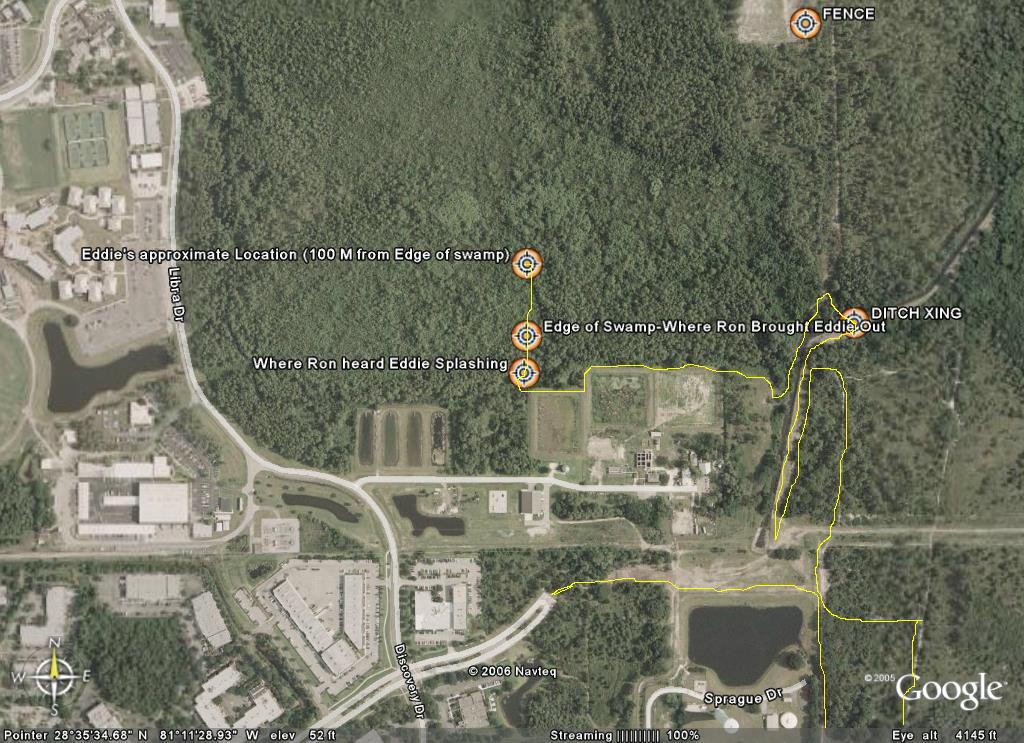
The search route I took is in yellow - Bob, Jerry, and I all crossed the ditch at the marked crossing point and re-split up after making it to the path. We were planning to meet at the fence (marked location) to regroup and continue searching.
Eddie Meadows Rescue
The first time I heard about Eddie being missing was in an email message from Roy, a triathlon friend.
Triknights,
It is Friday about 1:30 and I am asking for help if anyone is available some time today. A friend of mine (Ed) who works in research park went for a run yesterday at noon and never returned. The police are looking for him as are the UCF ROTC. But, I am thinking runners would know where runners would go. He is an older guy but very fit so he could have went 3 to 4 miles away from research park. This may be silly but I am planning on riding my bike where I think a marathon runner would go from research park to see if I can find him. He probably was going to run for 45 min to an hour. I could use help from some of you in searching too. Particularly, I do not know the trails around the campus that he probably did know and may have been on.
So, if anyone can spare some time today, I would appreciate you help in looking for Ed.
I will email the listserv if he is found.
Roy
I had planned on heading out Saturday to help with the search – but instead was feeling very fatigued on Saturday. I had seen that there were large crews that were looking for him and felt pretty secure that with all the hands out there on Saturday (and also on Sunday) that he would soon be found. By Sunday, when I heard there was no success – I felt some guilt that I had not helped. My wife Linda had told me that a friend Bob Putnam was trying to put together a group of experienced orienteers to look for him and I called Bob the next morning (morning) to tell him I would be meeting them at the command post Monday morning.
The scene at the command post was not what I had expected. Most of the people that had turned out to volunteer were in street clothes. I felt that we would need to be searching the deeply wooded areas. Bob, Jerry, and I were the only ones dressed correctly for what I expected the search would require. After getting the facts of where he was last seen and the direction Bob I and I made a decision on where we would search first. My theory and Bob was in a agreement was that he had looped back around to the east side of campus and had taken the back trails along the far east side of the UCF campus.
One other gentleman with 2 dogs (Bruce Truog) joined our group and we first decided the search the area of the ditch along the far east side of campus. I had ridden mountain bike from my house and planned to use it to help me cover more ground. While Bob and Jerry covered some of the rabbit trails on foot – I used the bike to scout ahead and behind along the east side of the ditch. Bruce went up the middle of the ditch with the dogs wearing hip waders), a truly amazing sight with the two hunting dogs in the lead.
Eventually Bob and Jerry and I bushwhacked across the ditch and after a few tries of heading into very thick brush we were able to get all three of us and the bike out to the north-south trail on the west side of the ditch. At that point we planned to split up to cover more terrain. My hunch had me thinking he was either in the thick woods west of the trail where we were, or in the deep swamp west of the water tower and north of Neptune Drive. I biked south (while Bob and Jerry headed north) and decided I would look for areas that were the ATV tracks from the previous days searching weren’t found. This took me along the retention ponds on the North side of Neptune Drive. Along that section I somehow entered into an area of bees, but only picked up one sting from one that had crawled into my shirt. My plan was to follow the treeline and fence west along the edge of the retention ponds and then hop the fence and follow a sparse trail on the north side back to my bike and then I’d meet up with Bob and the other team members.
It was extremely thick where I jumped the fence and it took me a few minutes to bushwhack my way to a more open area northeast of the fence corner. From there I was stopping about every 20-30 feet and listening for the signs of a body – the buzzing of flies and the sounds of carrion birds. My plan was to take the indistinct trail back through the woods to where I had dropped my bike. It was at this point I head the splash coming from within the Bayhead and I called out “hello”. I was immediately greeted by a series of “help!” calls. At this point I though another rescuer might be back in the swamp area and had found the body and was calling for help. I called “are you looking for Eddie?” and heard back “I am Eddie”. I had been walking (quickly) in the direction of the voice – trying not to make so much noise that I would not be able to hear the voice. I yelled back – “Stay there – I’m coming” and immediately broke into a full run directly into the swamp. We called out – “Can you see me?” and basically kept shouting until I came upon him about 100-150 meters back in about thigh deep water, The swamp was extremely thick at this point and was extremely tough to move through. I first checked his condition which was surprisingly good – he was tired and thirsty – covered in scratches and bites – but was lucid and standing. He asked me if I could help him find his way out of the swamp and I said sure. He was heading East which would have taken him much deeper into the swamp – we wanted to head south to get him out. At the same time I had the phone out and was calling 911. I had some frustration with the 911 operator who kept wanting an intersection to send rescue crews to. I eventually convinced her to send the crews to the UCF observatory and told her to please ask them to turn on their sirens so we could use them to keep our south bearing. When Eddie had seen my phone – he immediately asked to call his wife who he said would be worried and probably angry with him. I dialed his number and handed him the phone and he had a tearful conversation with what I think was his son on the other end.
We fought our way out of the swamp (Eddie mostly on his own power) and as we emerged the rescue crews were coming towards us from the road. Eddie was relieved to see an actual trail and despite being very thirsty and hungry he was eager to get out of the woods and actually led the entire crew out – jogging the last little bit to the ambulance. After he was safely in the ambulance I jogged back to get my bike and the rest of my team – who had already heard the news by the time I got to them. We headed back over to the rescue trucks where the press was waiting (they were fast) and showed the folks the details of the rescue.
Eddie had been in the woods from Thursday at noon, till the next Monday at 11 Am when he was found. He survived by staying low in the water of the swamp – keeping cool and preventing further dehydration. He had drunk the swamp water and eaten berries to survive. I was elated to have found him alive and OK – it was one incredible tale of survival.
Triknights,
It is Friday about 1:30 and I am asking for help if anyone is available some time today. A friend of mine (Ed) who works in research park went for a run yesterday at noon and never returned. The police are looking for him as are the UCF ROTC. But, I am thinking runners would know where runners would go. He is an older guy but very fit so he could have went 3 to 4 miles away from research park. This may be silly but I am planning on riding my bike where I think a marathon runner would go from research park to see if I can find him. He probably was going to run for 45 min to an hour. I could use help from some of you in searching too. Particularly, I do not know the trails around the campus that he probably did know and may have been on.
So, if anyone can spare some time today, I would appreciate you help in looking for Ed.
I will email the listserv if he is found.
Roy
I had planned on heading out Saturday to help with the search – but instead was feeling very fatigued on Saturday. I had seen that there were large crews that were looking for him and felt pretty secure that with all the hands out there on Saturday (and also on Sunday) that he would soon be found. By Sunday, when I heard there was no success – I felt some guilt that I had not helped. My wife Linda had told me that a friend Bob Putnam was trying to put together a group of experienced orienteers to look for him and I called Bob the next morning (morning) to tell him I would be meeting them at the command post Monday morning.
The scene at the command post was not what I had expected. Most of the people that had turned out to volunteer were in street clothes. I felt that we would need to be searching the deeply wooded areas. Bob, Jerry, and I were the only ones dressed correctly for what I expected the search would require. After getting the facts of where he was last seen and the direction Bob I and I made a decision on where we would search first. My theory and Bob was in a agreement was that he had looped back around to the east side of campus and had taken the back trails along the far east side of the UCF campus.
One other gentleman with 2 dogs (Bruce Truog) joined our group and we first decided the search the area of the ditch along the far east side of campus. I had ridden mountain bike from my house and planned to use it to help me cover more ground. While Bob and Jerry covered some of the rabbit trails on foot – I used the bike to scout ahead and behind along the east side of the ditch. Bruce went up the middle of the ditch with the dogs wearing hip waders), a truly amazing sight with the two hunting dogs in the lead.
Eventually Bob and Jerry and I bushwhacked across the ditch and after a few tries of heading into very thick brush we were able to get all three of us and the bike out to the north-south trail on the west side of the ditch. At that point we planned to split up to cover more terrain. My hunch had me thinking he was either in the thick woods west of the trail where we were, or in the deep swamp west of the water tower and north of Neptune Drive. I biked south (while Bob and Jerry headed north) and decided I would look for areas that were the ATV tracks from the previous days searching weren’t found. This took me along the retention ponds on the North side of Neptune Drive. Along that section I somehow entered into an area of bees, but only picked up one sting from one that had crawled into my shirt. My plan was to follow the treeline and fence west along the edge of the retention ponds and then hop the fence and follow a sparse trail on the north side back to my bike and then I’d meet up with Bob and the other team members.
It was extremely thick where I jumped the fence and it took me a few minutes to bushwhack my way to a more open area northeast of the fence corner. From there I was stopping about every 20-30 feet and listening for the signs of a body – the buzzing of flies and the sounds of carrion birds. My plan was to take the indistinct trail back through the woods to where I had dropped my bike. It was at this point I head the splash coming from within the Bayhead and I called out “hello”. I was immediately greeted by a series of “help!” calls. At this point I though another rescuer might be back in the swamp area and had found the body and was calling for help. I called “are you looking for Eddie?” and heard back “I am Eddie”. I had been walking (quickly) in the direction of the voice – trying not to make so much noise that I would not be able to hear the voice. I yelled back – “Stay there – I’m coming” and immediately broke into a full run directly into the swamp. We called out – “Can you see me?” and basically kept shouting until I came upon him about 100-150 meters back in about thigh deep water, The swamp was extremely thick at this point and was extremely tough to move through. I first checked his condition which was surprisingly good – he was tired and thirsty – covered in scratches and bites – but was lucid and standing. He asked me if I could help him find his way out of the swamp and I said sure. He was heading East which would have taken him much deeper into the swamp – we wanted to head south to get him out. At the same time I had the phone out and was calling 911. I had some frustration with the 911 operator who kept wanting an intersection to send rescue crews to. I eventually convinced her to send the crews to the UCF observatory and told her to please ask them to turn on their sirens so we could use them to keep our south bearing. When Eddie had seen my phone – he immediately asked to call his wife who he said would be worried and probably angry with him. I dialed his number and handed him the phone and he had a tearful conversation with what I think was his son on the other end.
We fought our way out of the swamp (Eddie mostly on his own power) and as we emerged the rescue crews were coming towards us from the road. Eddie was relieved to see an actual trail and despite being very thirsty and hungry he was eager to get out of the woods and actually led the entire crew out – jogging the last little bit to the ambulance. After he was safely in the ambulance I jogged back to get my bike and the rest of my team – who had already heard the news by the time I got to them. We headed back over to the rescue trucks where the press was waiting (they were fast) and showed the folks the details of the rescue.
Eddie had been in the woods from Thursday at noon, till the next Monday at 11 Am when he was found. He survived by staying low in the water of the swamp – keeping cool and preventing further dehydration. He had drunk the swamp water and eaten berries to survive. I was elated to have found him alive and OK – it was one incredible tale of survival.
Subscribe to:
Posts (Atom)