
Segment 1 - Santos to Land Bridge - This is a wonderful fast and flowing single track segment. There is very little technical, but very nice flow. Water and bathrooms are available at the land bridge trailhead. Enjoy this segment.

Segment 2 - Land Bridge to Ross Prarie - The technical difficulty of the trail increases here, but for most riders this will be incredibly fun. Canal Diggings which is a big loop you should do CLOCKWISE is a ton of fun along with Nayl's way and my favorite - the last mile of Ern'nBern which is one of the most incredible flow of any mountain bike trail. Ross Prarie Trailhead is a great stop for water. Bathrooms here too.

Segment 3 - Ross Prarie to Withlacoochee Trail - You leave Ross Prairie through the Florida Trail and after crossing SR200 use that to get to Limerock road. Follow Limerock Road (fast riding) to a small section of Tricycle Trail and through the Pruitt Memorial which is a special stop. Continue west on Limerock road, north to 484 and then west again on this white knuckle ride with plenty of large trucks going by. Don't miss the left turn at the gate to make the little L turn that takes you to the Dunnellon Trailhead. Highlight is the Rainbow River bridge. A little road ride and you are now at the Withlacoochee trailhead (water and restrooms here). The convenience store at the end of Dunnelon Trail is a good stop.
Segment 4 - Withlacoochee Trail - Just fun and fast riding on pavement on the Withlacoochee Trail. Just ride - there are some great places to stop in Hernando for burgers or chicken all right on the trail Don't miss the little trail jog here. Continue until you get to the big bridge overpass and make the climb up the north side.

Segment 5 - Florida Trail to Withlacoochee - The first section here is pretty cool, a nice little section of hiking trails. After you exit you will take the paved road to FR 9. As you cross SR44 there is an ABC Liquor Store on the left across from the Appleby's. Just saying it might come in handy later.

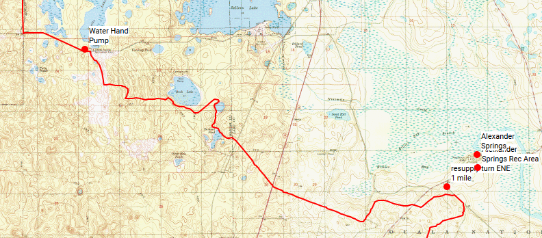
Segment 6 - Withlacoochee Citrus Tract - Take FR 9 (solid packed) to FR 10. If you need water a quick stop at Holder Mine is good (just at the intersection of FR9 and FR10). Bathrooms here. After West on FR10 head south on FR13 - also still pretty nice riding. A little road ride and a little confusing section around the pond are the only places you might have issues. Trail may have some pig rooting, soon enough you will hit pavement and approach Checkpoint 1 - Lake Lindsey Mall. Stock up here, hot Cuban sandwiches and everything else you may want or need for the long section to come.

Segment 7 - Heading to Croom - Even though this is mostly road, the dirt sections are rough and sandy. Also there is a right turn that you will probably miss - keep your eyes on the blue line and realize you will have to get your bike through a gate designed to prevent bikes.

Segment 8 - Croom Bike Trails - This section is incredible. Riders who are racing should fly through this section and go fast to be able to beat nightfall. For those who are going for the fun ride - enter after dark. If you are early, wait for nightfall - you will find out why. Some riders will take all night to complete this section, others will enjoy the fun and move on. Both groups are going to find some easy and some highly technical riding. If you are looking for some sleep the primitive camp near the exit is the best spot. Riding highlights are the quarry and drunken monkey.
Segment 9 - Withlacoochee Trail to Ridge Manor - If you need water (or rest) after exiting the bike trails (just after the primitive camp) then Silver Lake is your spot. Otherwise it is a short paved ride to Checkpoint 2 - Ridge Manor

Segment 10 - Richloam - Devil's Creek - Green Swamp - This next section starts with a short ride east on SR50 until you hit the dirt road and pay very close attention to the GPS track through the maze of sandy dirt roads which take you to the Orange Blazed crossing of Devil's Creek. This can be a shallow (feet dry) crossing all the way to a roaring river. This year it was the former. The riding here is all single track with quite a bit of pig rooting. Eventually you give way to sandy single track through beautiful open and hilly terrain and finally head out to Cummpressco Road and the Green Swamp Crossing.There is no water on this stretch.

Segment 11 - Cumpressco Road - Beautiful and fast riding on a solid coquina based road. The only hazard here is the occasional hunter's truck barreling down the road. There is no water on this stretch and the water at Cumpressco Hunters camp is not potable, but it is treatable.

Segment 11- Rock Ridge Road - Van Fleet Trail - Water Gage Road - This section starts out fast with paved riding. After crossing the river you come to the trailhead at Rock Ridge Road. Turn left and take the pavement to the Van Fleet trailhead. Here you have water, picnic tables, and a real bathroom. It is a great place to take a quick break. You will head north on the Van Fleet trail and right on water gage road. There is no condition where water road is fun, it will be a huge wet puddle or a dry sandy litter box. Just get across it and make your way to SR33.

Segment 12 - All the way to Clermont - Head north on SR33. This will be a white knuckle ride, SR33 is a truckers paradise and they go fast. You have a break along here at the Sunoco if it is open. A chance to grab a quick bite and fluid after the long trip from Ridge Manor. If you don't stop or they are not open it is not terribly far to Clermont from here. After turning right off SR33 you have a bit of a reprieve from traffic as you head to county road 561. After turning right on 561 you only have a short distance until you turn left again. If you are lucky enough to catch this section in daylight it's a trreat. Eventually you will come out on 474, another heavy traffic road and end up at Checkpoint 3 - the 7-11 at the corner of 474 and US27.
Segment 13 - Crossing Clermont - If you need anything (food, bike gear, repairs) this is the section to get it. You pass at least one of everything. Bad side - lots of traffic. Eventually you will get across the city, cross a construction area and some roads to take you to the Clermont Hills section of the ride (after crossing the turnpike).

Segment 14 - The Hills - This is actually quite a fun ride, you will cross some of the bigger hills in Florida including Sugarloaf. The climbs will give you some incredibly fun downhills. These are much more fun when the temp is above 50 and you are wearing more than a TShirt, but frozen nipples aside - a ton of fun. There is a lot of riding here which brings you to the Green Mountain Overlook. Make sure you check out the overlook, use the bathroom and then head across Lake Apopka.

Segment 15 - Lake Apopka - Another enjoyable segment, best enjoyed at Sunrise or Sundown. This is all fast riding and the lake is scenic and beautiful. There are bathrooms at the pump house and at the finish at Magnolia Park. There is also a camping area in magnolia Parka across 437. If you are looking for better accommodations follow the route into Apopka. For good inexpensive and friendly lodging I recommend the Regency Inn on 441, on your left just before you cross 441. Once you cross you will ride to the West Orange Trail and follow it to CP4 at the 7-11 in front of the Publix on Rock Springs Road. The McDonalds at CP4 is a great place to get some food - you will want it as there is no food between CP4 and CP5.

Segment 16 - Wekiva - This short section has some nice single track and double track with one walking section through a small wetland. When you hit post 19 and head onto the double track you will soon be at the Buck Lake crossing. Camp Cozy provides a possible camping spot.

Segment 17 - Rock Springs - This was at one time decent riding, some strategic mowing and a disker put an end to that. The horse barn has bathrooms and showers and the last chance for food and beer is at the store in Wekiva Falls.

Segment 18 - Seminole State Forest - Royal Trails - Maggie Jones - The first part of this is a lot of fun, a nice crossing over Blackwater Creek with fast riding on rock road. After exiting Seminole State Forest at Cassia Traihead go left to SR44 and right to Royal Trails. Pavement will yield to dirt road and you will complete the long Maggie Jones road to pavement again and Paisley Mart. It is wise to hit this in daylight or early evening as it is the last food before the final push to the finish. If it is closed you can still get water at Clearwater Lake.

Segment 19 - Paisley Bike Trails - Fun fast and flowing you will exit on Paisley Road turn left and reenter at the Orange Blazed Trail.
Segment 20 - FNST to Farles Lake - Fast riding but will likely change in the future - still a lot of fun.

Segment 21 - Bombing Range - Wide open, fast riding, scenic - all dirt. The last segment seems to drag on for its full 6 miles, but it is all good riding. As you ride this segment just think about how much forest there is here.

Segment 22 - Final push - You will pass through a combination of paved and unpaved roads. You will come out on CR314, cross the Oklawaha River bridge and head 1 1/2 miles west to the Marshall Swamp Trailhead. Take a quick breather here - water and bathrooms are here. Marshall Swamp is fun and fast and twisty single track and eventually brings you the pavement and the park on the other side and Baseline Park. From Baseline Park Trailhead it is a road ride to Santos and the finish.


