The original text of this article from Kate Santich Sentinel Staff Writer Posted September 24, 2006 is at
http://www.orlandosentinel.com/features/lifestyle/orl-eaglin06sep24,0,1136246.story
In case this link is down or removed here is the text only of the article. Many thanks to Kate who put in hard work and is an accomplished athlete and biker.
Perhaps there really are two kinds of people in the world, and the dividing line is this: Some see a fork in the road or a trail into the woods but continue contentedly on their way. And others think, I wonder where that goes. . .And they have to find out.
For about as long as anyone can remember, 43-year-old engineering professor Ron Eaglin has done the latter -- a trait that has led him through murky swamps and thorny thickets and the chigger-laden wilderness that is Central Florida. He has suffered hypothermia and heat exhaustion, a broken jaw, hallucinations and an inestimable number of insect bites."Deer flies, bees, ants, fleas, every type of spider known to man -- they've all had their piece of my flesh," he says. "Fire ants I don't even notice anymore."But Eaglin doesn't just forge ahead blithely. In two decades of zealous exploration, he has become intimately familiar with the region's ever-shrinking wild places.
He has become, as one friend puts it, "the guy you want looking for you if you're ever lost in the woods."
Eddie Meadows discovered that the hard way.Meadows is the 62-year-old jogger who this month spent four days lost in the woods near the University of Central Florida. Though Orange County deputy sheriffs and naval investigators searched for several days, Eaglin knew the area so well he figured there was only one place dense enough to cause a man to lose his bearings like that. Once Eaglin joined the search, it took only a few hours to find Meadows -- who by then was dehydrated, disoriented and in acute kidney failure. He had been only a quarter mile from a road."
People say, 'How can you not find your way out?' " Eaglin says. "Well, that's easy to ask -- until you've been there. You have to understand what it looks like and feels like to be in the middle of deep-canopied forest and swamp where you can't see more than 20 feet in front of you. If I blindfolded you and took you out in the woods, not more than 200 yards from a road, and then took the blindfold off, you would be lost -- and probably for a long time."
Eaglin, who has a few other things to keep him busy -- running UCF's engineering technology department, coaching his younger daughter's soccer team, training for adventure races, working on computer programs that have won him recognition from the Department of Homeland Security -- spent the next few days explaining the complexities of the backwoods to the media, including CNN and the BBC. But the following week he was back tromping around in the woods himself, this time to teach a class on orienteering, a blend of cross-country running and navigating through the woods with a map and compass to find hidden checkpoints.
"Hey, it's the hero!" teased a woman as Eaglin arrived. "I saw you on television."The professor blushed. "Yeah, well . . ." he offered sheepishly.On the one hand, Eaglin had been ecstatic to find Meadows. But he was also relieved."I was stopping about every 20 to 30 feet," he says, "and listening for the signs of a body" -- the buzzing of flies and the circling of vultures.In his element
Eaglin doesn't much fit the stereotype of an adventurer. At 5 feet 8 inches tall, he's not a particularly imposing figure. His wire-rimmed glasses, thinning hair and beard give him a professorial look. His nickname, because of his doctorate degree in environmental engineering, is Dr. Ron.But put him in his element, in the middle of nowhere in particular, and it's obvious he would have done just fine scouting alongside Lewis and Clark.
Hiking through the woods of Rock Springs Run State Preserve near Sorrento, Eaglin notices details most people might not -- elusive sand skinks, small patches of prickly pear, banana spiders waiting in the shadows. He points out the signs of man's intrusions -- the unnatural growth of small pine trees in the middle of a field, an abrupt end to the tree line where a bulldozer must have come through.
"And power lines -- you can't be lost if you can see power lines," he says, squinting into an early-afternoon sun. "If you follow it, it's going to take you to somebody who needs power or something that's giving power, but either way it's going to take you to humans."
Eaglin has been exploring woods since he was a kid, moving with his family from Missouri to Illinois, Nebraska, Georgia and finally South Carolina, where he took up cross-country and swimming, played soccer and became a Boy Scout.
He was, from early on, exceptionally bright.
"He excelled in school, taking college classes when he was only 14," says his father, Ronald Eaglin Sr., the past president of Morehead State University in Kentucky, who now lives south of Myrtle Beach. "He was teaching college professors how to use computers when he was still in high school."
Ron Jr.'s most remarkable quality was not his brilliance, though. It was his drive.
The summer he turned 15, Ron got a job on a textile-plant loading dock."He was the only young person out there," says his mother, Bonnie Eaglin. "And it was such hard work. He'd always come home completely exhausted, but he still wanted to swim with his team in the evenings. That's when we found out how much endurance he had. He didn't ever win, in part because he was so tired from working, but he just had so much drive. Nothing seemed to intimidate him."
Taking it to extremes
Consider his method of training for adventure races -- a team sport in which you are given a last-minute map and instructions to trek, mountain bike, rock-climb, kayak and swim through the wilderness, sometimes for several days on end with little or no sleep and carrying your own food and water.
For practice, Eaglin likes to print out U.S. Geological Survey maps from his computer, close his eyes and randomly point to a spot. Then he grabs a training buddy and goes off to find it.Once the point was a marshy area near the St. John's River. His first approach was blocked by barbed vines and briers. Next he decided to cross the marsh itself."At first it was knee deep, and we're happy," he says. "Then it was thigh deep. Then it was chest deep. And then we were swimming. And every time you took a stroke, you churned up what looked like chunks of peanut butter off the bottom and it came bubbling to the top."He found his spot and his way back -- although not before trekking through wire grass and enduring scores of paper-thin cuts all over his body.It was a most excellent workout, he says.
He has raced in searing heat and heavy winter rain. Once, 2 1/2 days into an event, amid a 65-mile mountain-biking section, he hallucinated that his teammates were some mysterious enemy chasing him, so he sprinted away to try to lose them in the woods. When they finally caught up to him, one of the men tackled him. After all, Eaglin was the only one with the map.
Another time, he crashed his road bike and broke his jaw, which required his mouth to be wired shut for six weeks.
His competitors say he is not just tough. He is patient, generous and methodical."Even if you're in the midst of a race, he's willing to give you instructions and advice," says Jason Amadori, 33, a fellow adventure racer from Windermere. "He may not help you find something, but he has no problem in helping you learn how to find it. He's not one to keep secrets just so he can win. He's an incredibly nice guy."
As president of the Central Florida Adventure Racers club and an orienteering expert, Eaglin also plots some of the courses himself. They are notoriously difficult.
"We have these green areas on the map that mean very, very thick vegetation," says Bob Putnam, founder of the Florida Orienteering Club, "and people speak of their unwillingness to go through these impassable areas. And Ron just looks at them, puzzled, and says, 'Everything is passable. It's just that sometimes the going is slower than other times.' "Life with RonIn the middle of Seminole County's Black Hammock Wilderness, amid the dense tangle of trees and brush, is a lovely, solar-paneled, Cracker-style wood-frame house with a climbing wall in the backyard, a ropes course in the front, three dogs, seven cats, one bunny and a large wayward frog.
This, quite fittingly, is the Eaglin home, shared by Ron, his wife of 12 years -- fellow engineer Linda Eaglin -- and daughters Catherine, 9, and Anna, 8.The girls' play room is dubbed "The Jungle Room," its walls painted with tropical birds and a jaguar and elephant, its shelves full of class projects and Ron's exotic musical instrument collection. The kids each have a computer, but television is limited to a single hour per week.
"It's not just that kids waste time watching TV," says Eaglin, heading out back to check a banana tree for ripe fruit. "They waste their lives."
Most mornings he awakens before daylight to run in the darkness through the woods -- which is where he has discovered the abandoned cats and dogs that are now part of the family. Then he rides his bicycle 11 miles to work, carrying 35 pounds of gear on his back, and swims half a mile at the university pool before teaching class and conducting research.After work, he pedals home, coaches soccer and sometimes does a second run.
If it sounds like a delicately planned existence, it's not.
In July, heading home from a family camping trip in the Ocala National Forest in their 1994 GMC van with its 180,000 miles on the odometer, Ron spotted a dirt road off to the side. "I wonder where that goes," he mused.
Of course he couldn't resist.He plowed onto the detour, flanked by heavy vegetation, until it opened up into a field of bright sunlight. In front of them, the road turned to sugar sand.
"Let's go through it," Ron said. His wife shook her head. Soon, of course, they would be digging at the sand, trying to get the van unstuck.
Linda eventually gave up, called for help on her cell phone, pulled out a lawn chair and read a book while she waited.
Catherine, who, like her sister, has been training with Dad for future adventure races, voiced concern that the lone bag of pretzels wouldn't carry them through the night. She began to build a spit on which she planned to cook wild turkeys. Anna launched construction on a shelter they could sleep in.
About three hours later, though, as the sun was sinking low in the sky, a tow truck finally showed up and hoisted them out.
"We were all filthy dirty, but Ron took us to a nice restaurant on the way home," Linda says. "And that's life with Ron -- always an adventure."
Kate Santich can be reached at 407-420-5503 or ksantich@orlandosentinel.com.First photo ran on page F1.
Friday, September 29, 2006


Tuesday, September 05, 2006
Search Path
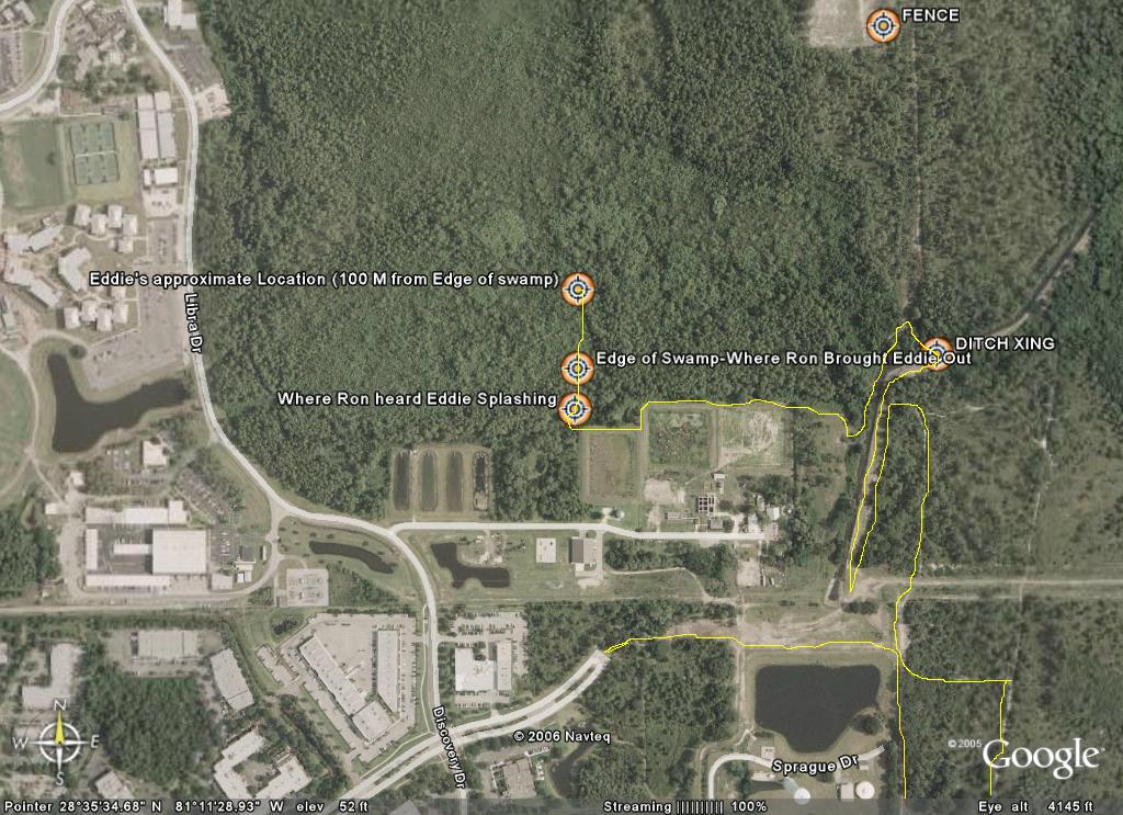
The search route I took is in yellow - Bob, Jerry, and I all crossed the ditch at the marked crossing point and re-split up after making it to the path. We were planning to meet at the fence (marked location) to regroup and continue searching.
Eddie Meadows Rescue
The first time I heard about Eddie being missing was in an email message from Roy, a triathlon friend.
Triknights,
It is Friday about 1:30 and I am asking for help if anyone is available some time today. A friend of mine (Ed) who works in research park went for a run yesterday at noon and never returned. The police are looking for him as are the UCF ROTC. But, I am thinking runners would know where runners would go. He is an older guy but very fit so he could have went 3 to 4 miles away from research park. This may be silly but I am planning on riding my bike where I think a marathon runner would go from research park to see if I can find him. He probably was going to run for 45 min to an hour. I could use help from some of you in searching too. Particularly, I do not know the trails around the campus that he probably did know and may have been on.
So, if anyone can spare some time today, I would appreciate you help in looking for Ed.
I will email the listserv if he is found.
Roy
I had planned on heading out Saturday to help with the search – but instead was feeling very fatigued on Saturday. I had seen that there were large crews that were looking for him and felt pretty secure that with all the hands out there on Saturday (and also on Sunday) that he would soon be found. By Sunday, when I heard there was no success – I felt some guilt that I had not helped. My wife Linda had told me that a friend Bob Putnam was trying to put together a group of experienced orienteers to look for him and I called Bob the next morning (morning) to tell him I would be meeting them at the command post Monday morning.
The scene at the command post was not what I had expected. Most of the people that had turned out to volunteer were in street clothes. I felt that we would need to be searching the deeply wooded areas. Bob, Jerry, and I were the only ones dressed correctly for what I expected the search would require. After getting the facts of where he was last seen and the direction Bob I and I made a decision on where we would search first. My theory and Bob was in a agreement was that he had looped back around to the east side of campus and had taken the back trails along the far east side of the UCF campus.
One other gentleman with 2 dogs (Bruce Truog) joined our group and we first decided the search the area of the ditch along the far east side of campus. I had ridden mountain bike from my house and planned to use it to help me cover more ground. While Bob and Jerry covered some of the rabbit trails on foot – I used the bike to scout ahead and behind along the east side of the ditch. Bruce went up the middle of the ditch with the dogs wearing hip waders), a truly amazing sight with the two hunting dogs in the lead.
Eventually Bob and Jerry and I bushwhacked across the ditch and after a few tries of heading into very thick brush we were able to get all three of us and the bike out to the north-south trail on the west side of the ditch. At that point we planned to split up to cover more terrain. My hunch had me thinking he was either in the thick woods west of the trail where we were, or in the deep swamp west of the water tower and north of Neptune Drive. I biked south (while Bob and Jerry headed north) and decided I would look for areas that were the ATV tracks from the previous days searching weren’t found. This took me along the retention ponds on the North side of Neptune Drive. Along that section I somehow entered into an area of bees, but only picked up one sting from one that had crawled into my shirt. My plan was to follow the treeline and fence west along the edge of the retention ponds and then hop the fence and follow a sparse trail on the north side back to my bike and then I’d meet up with Bob and the other team members.
It was extremely thick where I jumped the fence and it took me a few minutes to bushwhack my way to a more open area northeast of the fence corner. From there I was stopping about every 20-30 feet and listening for the signs of a body – the buzzing of flies and the sounds of carrion birds. My plan was to take the indistinct trail back through the woods to where I had dropped my bike. It was at this point I head the splash coming from within the Bayhead and I called out “hello”. I was immediately greeted by a series of “help!” calls. At this point I though another rescuer might be back in the swamp area and had found the body and was calling for help. I called “are you looking for Eddie?” and heard back “I am Eddie”. I had been walking (quickly) in the direction of the voice – trying not to make so much noise that I would not be able to hear the voice. I yelled back – “Stay there – I’m coming” and immediately broke into a full run directly into the swamp. We called out – “Can you see me?” and basically kept shouting until I came upon him about 100-150 meters back in about thigh deep water, The swamp was extremely thick at this point and was extremely tough to move through. I first checked his condition which was surprisingly good – he was tired and thirsty – covered in scratches and bites – but was lucid and standing. He asked me if I could help him find his way out of the swamp and I said sure. He was heading East which would have taken him much deeper into the swamp – we wanted to head south to get him out. At the same time I had the phone out and was calling 911. I had some frustration with the 911 operator who kept wanting an intersection to send rescue crews to. I eventually convinced her to send the crews to the UCF observatory and told her to please ask them to turn on their sirens so we could use them to keep our south bearing. When Eddie had seen my phone – he immediately asked to call his wife who he said would be worried and probably angry with him. I dialed his number and handed him the phone and he had a tearful conversation with what I think was his son on the other end.
We fought our way out of the swamp (Eddie mostly on his own power) and as we emerged the rescue crews were coming towards us from the road. Eddie was relieved to see an actual trail and despite being very thirsty and hungry he was eager to get out of the woods and actually led the entire crew out – jogging the last little bit to the ambulance. After he was safely in the ambulance I jogged back to get my bike and the rest of my team – who had already heard the news by the time I got to them. We headed back over to the rescue trucks where the press was waiting (they were fast) and showed the folks the details of the rescue.
Eddie had been in the woods from Thursday at noon, till the next Monday at 11 Am when he was found. He survived by staying low in the water of the swamp – keeping cool and preventing further dehydration. He had drunk the swamp water and eaten berries to survive. I was elated to have found him alive and OK – it was one incredible tale of survival.
Triknights,
It is Friday about 1:30 and I am asking for help if anyone is available some time today. A friend of mine (Ed) who works in research park went for a run yesterday at noon and never returned. The police are looking for him as are the UCF ROTC. But, I am thinking runners would know where runners would go. He is an older guy but very fit so he could have went 3 to 4 miles away from research park. This may be silly but I am planning on riding my bike where I think a marathon runner would go from research park to see if I can find him. He probably was going to run for 45 min to an hour. I could use help from some of you in searching too. Particularly, I do not know the trails around the campus that he probably did know and may have been on.
So, if anyone can spare some time today, I would appreciate you help in looking for Ed.
I will email the listserv if he is found.
Roy
I had planned on heading out Saturday to help with the search – but instead was feeling very fatigued on Saturday. I had seen that there were large crews that were looking for him and felt pretty secure that with all the hands out there on Saturday (and also on Sunday) that he would soon be found. By Sunday, when I heard there was no success – I felt some guilt that I had not helped. My wife Linda had told me that a friend Bob Putnam was trying to put together a group of experienced orienteers to look for him and I called Bob the next morning (morning) to tell him I would be meeting them at the command post Monday morning.
The scene at the command post was not what I had expected. Most of the people that had turned out to volunteer were in street clothes. I felt that we would need to be searching the deeply wooded areas. Bob, Jerry, and I were the only ones dressed correctly for what I expected the search would require. After getting the facts of where he was last seen and the direction Bob I and I made a decision on where we would search first. My theory and Bob was in a agreement was that he had looped back around to the east side of campus and had taken the back trails along the far east side of the UCF campus.
One other gentleman with 2 dogs (Bruce Truog) joined our group and we first decided the search the area of the ditch along the far east side of campus. I had ridden mountain bike from my house and planned to use it to help me cover more ground. While Bob and Jerry covered some of the rabbit trails on foot – I used the bike to scout ahead and behind along the east side of the ditch. Bruce went up the middle of the ditch with the dogs wearing hip waders), a truly amazing sight with the two hunting dogs in the lead.
Eventually Bob and Jerry and I bushwhacked across the ditch and after a few tries of heading into very thick brush we were able to get all three of us and the bike out to the north-south trail on the west side of the ditch. At that point we planned to split up to cover more terrain. My hunch had me thinking he was either in the thick woods west of the trail where we were, or in the deep swamp west of the water tower and north of Neptune Drive. I biked south (while Bob and Jerry headed north) and decided I would look for areas that were the ATV tracks from the previous days searching weren’t found. This took me along the retention ponds on the North side of Neptune Drive. Along that section I somehow entered into an area of bees, but only picked up one sting from one that had crawled into my shirt. My plan was to follow the treeline and fence west along the edge of the retention ponds and then hop the fence and follow a sparse trail on the north side back to my bike and then I’d meet up with Bob and the other team members.
It was extremely thick where I jumped the fence and it took me a few minutes to bushwhack my way to a more open area northeast of the fence corner. From there I was stopping about every 20-30 feet and listening for the signs of a body – the buzzing of flies and the sounds of carrion birds. My plan was to take the indistinct trail back through the woods to where I had dropped my bike. It was at this point I head the splash coming from within the Bayhead and I called out “hello”. I was immediately greeted by a series of “help!” calls. At this point I though another rescuer might be back in the swamp area and had found the body and was calling for help. I called “are you looking for Eddie?” and heard back “I am Eddie”. I had been walking (quickly) in the direction of the voice – trying not to make so much noise that I would not be able to hear the voice. I yelled back – “Stay there – I’m coming” and immediately broke into a full run directly into the swamp. We called out – “Can you see me?” and basically kept shouting until I came upon him about 100-150 meters back in about thigh deep water, The swamp was extremely thick at this point and was extremely tough to move through. I first checked his condition which was surprisingly good – he was tired and thirsty – covered in scratches and bites – but was lucid and standing. He asked me if I could help him find his way out of the swamp and I said sure. He was heading East which would have taken him much deeper into the swamp – we wanted to head south to get him out. At the same time I had the phone out and was calling 911. I had some frustration with the 911 operator who kept wanting an intersection to send rescue crews to. I eventually convinced her to send the crews to the UCF observatory and told her to please ask them to turn on their sirens so we could use them to keep our south bearing. When Eddie had seen my phone – he immediately asked to call his wife who he said would be worried and probably angry with him. I dialed his number and handed him the phone and he had a tearful conversation with what I think was his son on the other end.
We fought our way out of the swamp (Eddie mostly on his own power) and as we emerged the rescue crews were coming towards us from the road. Eddie was relieved to see an actual trail and despite being very thirsty and hungry he was eager to get out of the woods and actually led the entire crew out – jogging the last little bit to the ambulance. After he was safely in the ambulance I jogged back to get my bike and the rest of my team – who had already heard the news by the time I got to them. We headed back over to the rescue trucks where the press was waiting (they were fast) and showed the folks the details of the rescue.
Eddie had been in the woods from Thursday at noon, till the next Monday at 11 Am when he was found. He survived by staying low in the water of the swamp – keeping cool and preventing further dehydration. He had drunk the swamp water and eaten berries to survive. I was elated to have found him alive and OK – it was one incredible tale of survival.
Thursday, July 20, 2006
Setting the ACC (Awards)


As a race director there are a lot of elements that you have to take care of. One of the most difficult to me is the awards. We always solicit the local sponsors for cool stuff to give-a-way. Our primary sponsor Travel Country Outdoors always comes through with some nice gear so a big thanks to them. It is always nice to have sponsors that will support local groups like CFAR. For the ACC we wanted to have trophies that were special, especially considering that teams will have spent well over 24 hours racing. This is not another 5K race which is over in 20 minutes (15 for faster runners). Luckily my wife Linda was able to take one of my ideas and turn it into a really creative trophy. Pictures here show her working on making these trophies. The racers finishing well in this race will be treated to a one of a kind and truly "cool" trophy at the end.
Tuesday, May 30, 2006
Florida Coast to Coast Croom Bike

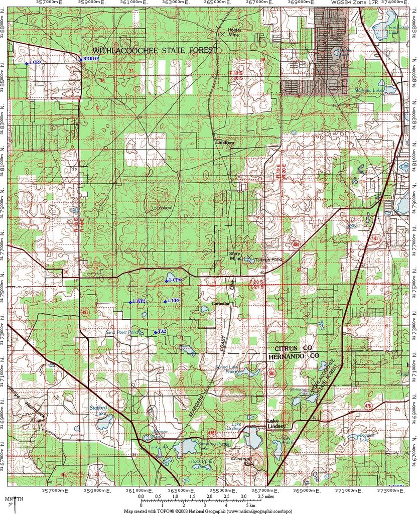
This is the map for the Witlacoochee portion of the bike leg. Instructions simply said to remain on the trails and you would pass by the controls. There was some navigation required, but this was pretty straightforward for most teams.
Florida C2C Trek with CP3

Here are the passport instructions for this section and also the map that the competitors had with the coordinates plotted for CP2, CP3, and the waypoints. I will let competitors answer as to how they attacked CP3. I personally would have triangulated from the hilltop (north) and the re-entrant (southeast) which were visible from the Florida Trail in this area.
Trek to:
From bike drop take old Jeep Trail East to Florida Trail UTM 358828 3185621 and proceed South on foot trail. No Bushwhacking is permitted within the Citrus Tract.
1-CP2 UTM 361824 3178594
1-CP3 UTM 359340 3176622
Cross 480 (do not travel along 480 on foot, penalty for travel along 480 is 4 hours)
1-CP4 UTM 362377 3175211
Proceed South to gate at UTM 362320 3174230, proceed to FR26 at UTM 360656 3173050, and on to TA2 at UTM 361831 3172801). Check in at TA2.
Teams spent quite a bit of time searching for CP3 which was located in a cave. CP2 was removed from the course. At this point the course conditions were quite hot and some teams were without water through a good amount of this section. The cave did have a foot trail leading to it.
Monday, May 29, 2006
Florida Coast to Coast 2006 Leg 3
Florida Coast to Coast
Passport Instructions 2
Maps: Withlacoochee Croom Bike 1:50K, Green Swamp Bike 1:100K, Poyner to Lake Marion Bike 1:100K, Lake Marion Road Map
This is a very long bike leg with no access to water or crews for long stretches. No crew interaction is allowed. Plan on a minimum of 10 hours of water. Some checkpoints will be manned with available water. Follow standard AR rules, you may get water or food from locals or stores.
Exit the TA on FR 28 West and go south on Brittle Road to Ponce DeLeon Blvd and proceed east to 476. Proceed with caution through the intersection of 476 and 581 continuing to the intersection of Daly Road UTM 372776 3169340 (no CP). Go south on Daly Road to Forest Road Intersection at UTM 372753 3165264 (no CP) and head east on Forest Road to Yellow Bike Trail at UTM 372954 3165264 (no CP). Follow yellow trail to CP1.
2-CP1 – UTM 373770 3163364 (Tucker Hill Parking Area).
Cutoff: Teams arriving at CP1 after 1600 on Friday will be diverted directly to CP5.
2-CP2 – UTM 374810 3162827 (travel on bike trails only)
2-CP3 – UTM 376866 3162062 (travel on bike trails only)
2-CP4 – UTM 378795 3162840 (travel on bike trails only)
2-CP5 – UTM 379409 3163976 (travel on bike trails only)
Travel South on Rail Trail to UTM 382940 3149008 (no CP, not on supplied map, simply follow rail trail past SR 50 bridge), intersection at Trilby (convenience store located near intersection of 98 and 575, recommend stocking up here). Head east to Bower Road at UTM 385206 3149368 (no CP). Head South easterly then South to the gate at UTM 385384 3147641 (no CP). Cross gate and follow dirt road to river crossing at UTM 386154 3146818 (water is shallow or we will have boats) and continue to CP6.
2-CP6 – UTM 390024 3137119 (Gate to Green Swamp by Hunt Station)
2-CP7 – UTM 400172 3137351 (teams may split up between CP5 and CP7)
2-CP7A - UTM 402604 3141998, collect coin at this CP
2-CP7B –UTM 404848 3134261 collect coin at this CP
2-CP8 – UTM 406219 3137388 (teams must rejoin after CP7)
2-CP9 – UTM 408743 3145561 If gate is closed, climb over it.
2-CP10 – UTM 409652 3147983 (Bay Lake Road Parking Area for Van Fleet Trail)
2-CP11 – UTM 416092 3131114 (Poyner, water available along trailheads).
Follow Poyner road east to SR 33 and proceed south to Van Fleet Road. Travel on grass along SR 33 only (4 hour penalty for violation). Cross 33 at Van Fleet Road (UTM 418704 3129013, no CP) and follow to Brown Shin and then to Deen Still Road. Follow Deen Still Road east to Loughman.
2-CP12 – UTM 444550 3124000 (Loughman Post Office).
2-CP13 – UTM 445252 3110746 (End of Baker Dairy Road) Treeline. Continue south to next intersection and head east to CP14.
2-CP14 – UTM 445561 3110052 ( Lake Marion Creek Road).
Follow Hatchineha Road head east to TA 3 – Hatchineha Boat Ramp at 455735 3100758
[Note: Plotted points on these maps may not correspond to the passport - these maps were created prior to the final completion of the passport locations]
Information about this leg:
This 135 mile bike leg through Croom, Green Swamp, that ended at Lake Hatchineha proved to be quite punishing with difficult navigation, tough terrain, and a lot of heat (and darkness). I will be doing more blog postings with other maps from these section. These maps are not the final maps teams received - but 1:100K scale maps I created while planning the course. Teams received more detailed maps for these sections. If anyone requests (via comments) the detailed maps I will post them with the final control points plotted.
Passport Instructions 2
Maps: Withlacoochee Croom Bike 1:50K, Green Swamp Bike 1:100K, Poyner to Lake Marion Bike 1:100K, Lake Marion Road Map
This is a very long bike leg with no access to water or crews for long stretches. No crew interaction is allowed. Plan on a minimum of 10 hours of water. Some checkpoints will be manned with available water. Follow standard AR rules, you may get water or food from locals or stores.
Exit the TA on FR 28 West and go south on Brittle Road to Ponce DeLeon Blvd and proceed east to 476. Proceed with caution through the intersection of 476 and 581 continuing to the intersection of Daly Road UTM 372776 3169340 (no CP). Go south on Daly Road to Forest Road Intersection at UTM 372753 3165264 (no CP) and head east on Forest Road to Yellow Bike Trail at UTM 372954 3165264 (no CP). Follow yellow trail to CP1.
2-CP1 – UTM 373770 3163364 (Tucker Hill Parking Area).
Cutoff: Teams arriving at CP1 after 1600 on Friday will be diverted directly to CP5.
2-CP2 – UTM 374810 3162827 (travel on bike trails only)
2-CP3 – UTM 376866 3162062 (travel on bike trails only)
2-CP4 – UTM 378795 3162840 (travel on bike trails only)
2-CP5 – UTM 379409 3163976 (travel on bike trails only)
Travel South on Rail Trail to UTM 382940 3149008 (no CP, not on supplied map, simply follow rail trail past SR 50 bridge), intersection at Trilby (convenience store located near intersection of 98 and 575, recommend stocking up here). Head east to Bower Road at UTM 385206 3149368 (no CP). Head South easterly then South to the gate at UTM 385384 3147641 (no CP). Cross gate and follow dirt road to river crossing at UTM 386154 3146818 (water is shallow or we will have boats) and continue to CP6.
2-CP6 – UTM 390024 3137119 (Gate to Green Swamp by Hunt Station)
2-CP7 – UTM 400172 3137351 (teams may split up between CP5 and CP7)
2-CP7A - UTM 402604 3141998, collect coin at this CP
2-CP7B –UTM 404848 3134261 collect coin at this CP
2-CP8 – UTM 406219 3137388 (teams must rejoin after CP7)
2-CP9 – UTM 408743 3145561 If gate is closed, climb over it.
2-CP10 – UTM 409652 3147983 (Bay Lake Road Parking Area for Van Fleet Trail)
2-CP11 – UTM 416092 3131114 (Poyner, water available along trailheads).
Follow Poyner road east to SR 33 and proceed south to Van Fleet Road. Travel on grass along SR 33 only (4 hour penalty for violation). Cross 33 at Van Fleet Road (UTM 418704 3129013, no CP) and follow to Brown Shin and then to Deen Still Road. Follow Deen Still Road east to Loughman.
2-CP12 – UTM 444550 3124000 (Loughman Post Office).
2-CP13 – UTM 445252 3110746 (End of Baker Dairy Road) Treeline. Continue south to next intersection and head east to CP14.
2-CP14 – UTM 445561 3110052 ( Lake Marion Creek Road).
Follow Hatchineha Road head east to TA 3 – Hatchineha Boat Ramp at 455735 3100758
[Note: Plotted points on these maps may not correspond to the passport - these maps were created prior to the final completion of the passport locations]
Information about this leg:
This 135 mile bike leg through Croom, Green Swamp, that ended at Lake Hatchineha proved to be quite punishing with difficult navigation, tough terrain, and a lot of heat (and darkness). I will be doing more blog postings with other maps from these section. These maps are not the final maps teams received - but 1:100K scale maps I created while planning the course. Teams received more detailed maps for these sections. If anyone requests (via comments) the detailed maps I will post them with the final control points plotted.
Coast to Coast Leg 2
 Transition to Bikes at TA 1
Maps: Bike Maze Road Map (receive at TA1), TA1 to Bike Drop 1:50K, Withlacoochee Citrus Tract 1:24K
Check out of TA before proceeding on bike leg (1 hour penalty for not checking out). Cross US19 only at Maze entrance UTM 347113 3185650, travel in grass only is permitted along US19, no travel on Grover Cleveland and Lecanto/491 (4 hour Penalty)
Bike Maze and punch Maze Points (MP’s):
MP1 UTM 350258 3186615
MP2 UTM 351950 3186419
MP3 UTM 353516 3185232
MP4 UTM 355657 3185606
After MP4, proceed on the dirt trail North of W. Noble St. to Lecanto Rd and proceed to Bike Drop at UTM 358491 3185862 (no control point at this location)
Drop bikes and transition to Trek. No interaction with crews at this location is permitted.
Trek to:
From bike drop take old Jeep Trail East to Florida Trail UTM 358828 3185621 and proceed South on foot trail. No Bushwhacking is permitted within the Citrus Tract.
1-CP2 UTM 361824 3178594
1-CP3 UTM 359340 3176622
Cross 480 (do not travel along 480 on foot, penalty for travel along 480 is 4 hours)
1-CP4 UTM 362377 3175211
Proceed South to gate at UTM 362320 3174230, proceed to FR26 at UTM 360656 3173050, and on to TA2 at UTM 361831 3172801). Check in at TA2.
The supplied map does not contain the entire bike maze, but you can get the idea from the left hand side. The roads in the maze are a mixture of paved and dirt - though we pretty much made sure teams had to go on the dirt roads. It took most teams about 3-4 hours to complete the bike maze and get to the bike drop. At the bike drop teams left their bikes and headed out on foot through a few CP's to TA2. This section caused a lot of teams heartburn as they had a difficult time finding CP3 which was in a cave.
Coast to Coast 2006 Leg 1
Florida Coast to Coast
Passport Instructions 1
Maps(1): Suncoast Paddle Start to TA1 1:50K
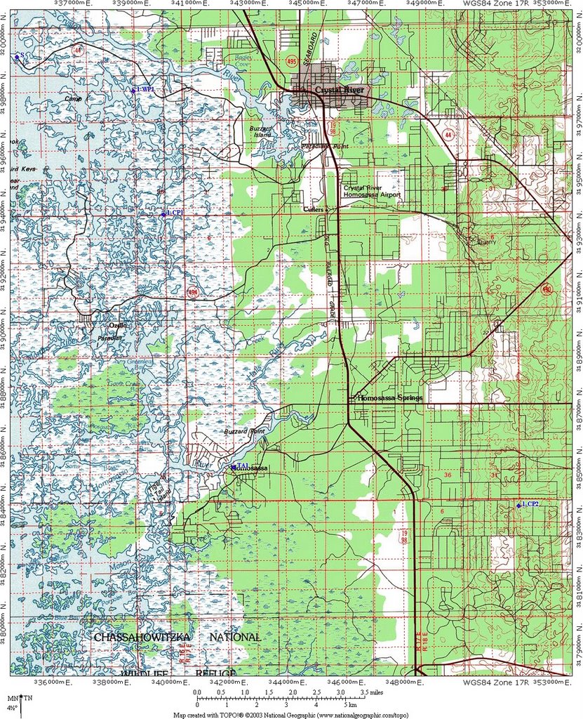
Race Start is at UTM 335050 3199231 Boat Ramp at end of SR 44. This is shown as dashed line on USGS map, but is a fully paved road.
Race will start at 1 AM Friday with a paddle. Teams should be in the water and ready to go at 1 AM.
Paddle to Canoe Trail Marker 2 located at UTM 338992 3197998. There is no checkpoint at this point. Teams must follow the Canoe Trail to CP1
1-CP1 - UTM 339892 3193296
Paddle to Transition Area (TA) 1 Located at Riverside Boat Ramp UTM 342246 3185181. Check in with TA staff and pick up map for the Maze. Portage boats to TA without crew assistance.
Section 1 Results
Teams moved through this section very rapidly with Mighty Dog moving through this paddle in about 2 1/2 hours. Paddling conditions were excellent with the 1 AM start, cool and calm waters with no wind. Teams continued to move through this section with Too Blue finishing in 6 hours - they were moving slowly due to boat problems.
Monday, May 08, 2006
Talon Race 2006
This was the 4th time I would be bringing my team to race in the Talon 12 hour Adventure Race. This race over the past years had provided an incredible challenge mostly due to the clever designs of the race director, Jim Hartnett, and the amazing terrain offered by Alafia River State Park. As our team (Greg, Jamie, Jeff, and I) got together at the hotel room the night before the race we had the shared feeling that you get before a race when you feel that things are going to go well the next day. Because anything can happen in AR and even for the best teams there is no guarantee of even finishing there is always a high level of uncertainty to the outcome of any race. Having finished second in this race three years in a row, I was determined to take away a first place trophy this time around, but in adventure racing determination and preparation just increase your chances – they are a far cry from a guarantee. In each of the previous three years our team had tried so hard to overcome mistakes we made early in the race, only to fall short each time to the competition.
Because the premiere division of the Talon is the three person coed, we decided to race as a 3 person team and have Greg race as a soloist. This would be the second time Jeff would be racing with Team Travel Country Outdoors, he had proved to have solid athletic ability and had “seasoned” as a racer tremendously since the last time we had raced together. We grouped together at the start line and listened to the last minute instructions, which basically said that we would have a 4 PM cutoff to be able to start the final bike leg of the race (which looked to be a solid 3-4 hour leg). Jim told the teams the start of the race was single track biking, but to keep the teams from bunching up we would start with a roughly 1 mile trail run and then hop on the bikes. He then pointed south to an arrow sign and said “go”. We had our bikes and bike shoes and bike gear (including helmets) on, but as a team we simply dropped our bikes and started running.
Jamie led the way through the roughly 1 mile trail run that went up and down old phosphate mine pilings and we were the first team to finish and get onto the bikes. This turned out to be very fortuitous as we immediately went into an advanced single track bike trail called “roller coaster” which was aptly named. Getting behind a slower bike team here would have been a problem as passing in “Roller Coaster” would have been difficult. This single track bike allowed us to build some distance on the main pack and only one team (a 2 person male team of strong bikers) was staying with us. As we entered another bike trail called “Rock Garden” we came to an unmarked intersection and lost some time figuring out what to do. The other team passed us and just as I crested a particularly large hill I got distracted and went flying over the handlebars. A quick body check told me nothing was broken, except I had some nasty welts and blood on my knees and my hand hit a rock hard and immediately started swelling and throbbing. I lost some time repairing my bike as my bike seat was facing 90 degrees with my bike frame, and bashing it back into a correct angle was difficult with one hand out of commission.
The bruised hand continued to throb through the remaining miles of the single track ride. We went into some easier single track, and that helped me get my focus back on the biking – but in a race easier single track simply means a great speed and we simply replaced difficulty with speed. Even a mild single track curve is tricky at 15 mph. We came off the bike ride less than a minute behind the only team in front of us and decided we would complete all the special tasks required in the race while we were in the Transition. We bobbed for apples (quite refreshing with the added bonus of being able to eat the apple), completed a Sudoku Challenge, did a blindfolded maze, and crossed a rope challenge that required you to swing from rope to rope transferring to the other rope with each swing. This allowed some teams who chose to skip the special tests (and do them later) to pass us. But we were feeling good going into the next leg of the race – the paddle.
The paddle leg was most aptly described as the portage leg. We portaged to a small lake, punched a control in the middle of the lake, and then paddled to the shore where we repeated this in the next lake. After the third portage I made our first (and only major) mistake of the race. Misreading a part of the map I did not realize that the flags in one area were in water (it was not blue) and we portaged the boats to a wooded area and started on foot for the controls (we would return to portage the boats to the next location). After 10 minutes of an extremely difficult bushwhack we got to the controls – close together in the middle of a completely slime covered pond. Since we were there we decided to swim out to them, but even that proved challenging as the shoreline was basically waist deep muck. We did get the controls but returning to the correct plan – cost us a serious 20+ minutes (we saw plenty of teams go by) and put us back on the intended plan (to use our boats).
The final portion of the paddle was a 2 mile paddle down the Alafia River (a short ¼ mile portage to the river) and then a lake paddle of about 3 miles. With Florida currently in the midst of a major drought, the Alafia River was best referred to as the Alafia series of shallow flowing ponds. The Alafia paddle had never been easy in any race – but this time we never even bothered getting into the boats. We dragged, pushed, pulled, slogged, and carried the boats to the bridge. We learned there that the remaining section of the paddle (where we could actually paddle) had been cut short as teams were way behind the time projection of the race. We would be heading on foot to a single checkpoint and then back to the transition area.
The trek would take us north about 2 miles through some tough terrain (waist high grass in an old phosphate mine). A couple of teams followed with us but soon dropped off as we proceeded northward – it was all full sun and the 90 degree heat was starting to take its toll on teams. We reached the location of the checkpoint (it was not difficult) to find a ribbon in a tree. We searched the area and I decided to call in to let Jim know the flag was missing (or possibly misplaced). After he described the ribbon and its location (including a detailed description of the tree in which it was hanging) I was more sure that we were in the correct location (I was already at 100%). We marked the ribbon to prove we were there and headed west for a bushwhack back through the river basin to the canoe launch. It was a due west bushwhack and we came out exactly at the launch as expected and then headed by trail back to the main TA.
At the TA we switched to bikes to do a fairly short bike to 2 easy to find control points. This was an easy and uneventful ride and took us back to the main TA and the most challenging leg of the race – the orienteering leg. The passport had the not so cryptic message “good luck” for the teams as they started this leg of the race, and it proved to be an apt message. We would be navigating from an aerial photo that basically had 2 pieces of information – water or canopy (trees). The water was also not a good description – water meant duckweed covered, shallow, muddy terrain.
As we entered the woods looking for CP19 (which was a bit too far west of the mapped location, but all the other flags were perfectly located) – I quickly shifted my time estimate of this leg. The first 200 feet of travel took us a solid 5 minutes in the thick hilly terrain. As it turns out the area was a long abandoned phosphate mine (now overgrown). The hills were old phosphate pilings ranging in height from 30 to 70 feet and steep. The majority of the terrain consisted of crawling, pulling, and dragging up to the top of the hills and then sliding down the other side. Add in the spiders (plenty of spider nests), the thorn covered vines, and the waist deep mud at many locations – the going was quite slow. We did controls up to control 31 in order, after control 31 I decided to use a trail in the area to exit for a while and re-attack control 36 from an actual trail. We had been working with another team up to control 28 – but they decided to bail out when we decided to swim the lake section between control 28 and 29. We met up with them again at control 36 going the opposite direction. We gathered controls 36 through 32 working backwards and decided to swim the last lake near control 37 before heading back. We had debated skipping some of the controls as it was nearing 3:30 PM and we knew we would need to make the 4 PM cutoff for the bike leg. In the end we got them all and even rejoined with the team we had been working with at CP37. We were running at that point because we could – we were happy to not be fighting up and down hills. We ran back to the TA, about a mile and it took less time to run this than it did to go from the CP’s that had been separated by 500 feet.
We arrived back at the TA at 3:45 PM and prepared for what I knew would be a 3+ hour bike ride in full sun on sand roads. Bladders and water bottles were full and the team had re-hydrated and eaten. We headed to the TA checkout and then learned that the bike ride had been shortened to a single checkpoint. It was 3:55 PM and there were only us and one other team in the TA, the one we had traveled with on the orienteering. They were still in the TA and looked like they had no intention of leaving any time soon (one team-mate was obviously hurting and they were working to get recovered). I looked at the new course and quickly figured that we would have at most 30 minutes of riding to be finished. We were disappointed (a little) as we had psyched up for the ride, but at the same time relieved. It took us little over 20 minutes to visit the single final CP and return to the TA and finish the race. It was a nice ride and knowing that there were no teams right on our tail (we would have seen them in the open terrain) allowed us to complete it without pushing ourselves too hard. After finishing we quickly debated visiting some of the other CP’s on the bike leg for fun – but decided that we had had enough (8 ½ hours of racing) and would relax. We cheered in the other teams, and chatted for a while – and we all had time for cold outdoor showers in the bike wash.
In the end the race was excellent – the course was challenging and required strength, skill, and endurance. All of the race sections were excellent. The orienteering – as hard as it was – was one of the highlights of any race I had done. I was glad our team overcame the mistakes we made by continuing solidly through the challenging course. I finally got that 1st place trophy (sitting next to the three second place trophies). All of the other adventure racers that were out there I am sure are feeling the bruises that are an inevitable outcome of race terrain like this. The bruises fade quickly – but the memories and the stories last a lot longer – and get better with time.
Because the premiere division of the Talon is the three person coed, we decided to race as a 3 person team and have Greg race as a soloist. This would be the second time Jeff would be racing with Team Travel Country Outdoors, he had proved to have solid athletic ability and had “seasoned” as a racer tremendously since the last time we had raced together. We grouped together at the start line and listened to the last minute instructions, which basically said that we would have a 4 PM cutoff to be able to start the final bike leg of the race (which looked to be a solid 3-4 hour leg). Jim told the teams the start of the race was single track biking, but to keep the teams from bunching up we would start with a roughly 1 mile trail run and then hop on the bikes. He then pointed south to an arrow sign and said “go”. We had our bikes and bike shoes and bike gear (including helmets) on, but as a team we simply dropped our bikes and started running.
Jamie led the way through the roughly 1 mile trail run that went up and down old phosphate mine pilings and we were the first team to finish and get onto the bikes. This turned out to be very fortuitous as we immediately went into an advanced single track bike trail called “roller coaster” which was aptly named. Getting behind a slower bike team here would have been a problem as passing in “Roller Coaster” would have been difficult. This single track bike allowed us to build some distance on the main pack and only one team (a 2 person male team of strong bikers) was staying with us. As we entered another bike trail called “Rock Garden” we came to an unmarked intersection and lost some time figuring out what to do. The other team passed us and just as I crested a particularly large hill I got distracted and went flying over the handlebars. A quick body check told me nothing was broken, except I had some nasty welts and blood on my knees and my hand hit a rock hard and immediately started swelling and throbbing. I lost some time repairing my bike as my bike seat was facing 90 degrees with my bike frame, and bashing it back into a correct angle was difficult with one hand out of commission.
The bruised hand continued to throb through the remaining miles of the single track ride. We went into some easier single track, and that helped me get my focus back on the biking – but in a race easier single track simply means a great speed and we simply replaced difficulty with speed. Even a mild single track curve is tricky at 15 mph. We came off the bike ride less than a minute behind the only team in front of us and decided we would complete all the special tasks required in the race while we were in the Transition. We bobbed for apples (quite refreshing with the added bonus of being able to eat the apple), completed a Sudoku Challenge, did a blindfolded maze, and crossed a rope challenge that required you to swing from rope to rope transferring to the other rope with each swing. This allowed some teams who chose to skip the special tests (and do them later) to pass us. But we were feeling good going into the next leg of the race – the paddle.
The paddle leg was most aptly described as the portage leg. We portaged to a small lake, punched a control in the middle of the lake, and then paddled to the shore where we repeated this in the next lake. After the third portage I made our first (and only major) mistake of the race. Misreading a part of the map I did not realize that the flags in one area were in water (it was not blue) and we portaged the boats to a wooded area and started on foot for the controls (we would return to portage the boats to the next location). After 10 minutes of an extremely difficult bushwhack we got to the controls – close together in the middle of a completely slime covered pond. Since we were there we decided to swim out to them, but even that proved challenging as the shoreline was basically waist deep muck. We did get the controls but returning to the correct plan – cost us a serious 20+ minutes (we saw plenty of teams go by) and put us back on the intended plan (to use our boats).
The final portion of the paddle was a 2 mile paddle down the Alafia River (a short ¼ mile portage to the river) and then a lake paddle of about 3 miles. With Florida currently in the midst of a major drought, the Alafia River was best referred to as the Alafia series of shallow flowing ponds. The Alafia paddle had never been easy in any race – but this time we never even bothered getting into the boats. We dragged, pushed, pulled, slogged, and carried the boats to the bridge. We learned there that the remaining section of the paddle (where we could actually paddle) had been cut short as teams were way behind the time projection of the race. We would be heading on foot to a single checkpoint and then back to the transition area.
The trek would take us north about 2 miles through some tough terrain (waist high grass in an old phosphate mine). A couple of teams followed with us but soon dropped off as we proceeded northward – it was all full sun and the 90 degree heat was starting to take its toll on teams. We reached the location of the checkpoint (it was not difficult) to find a ribbon in a tree. We searched the area and I decided to call in to let Jim know the flag was missing (or possibly misplaced). After he described the ribbon and its location (including a detailed description of the tree in which it was hanging) I was more sure that we were in the correct location (I was already at 100%). We marked the ribbon to prove we were there and headed west for a bushwhack back through the river basin to the canoe launch. It was a due west bushwhack and we came out exactly at the launch as expected and then headed by trail back to the main TA.
At the TA we switched to bikes to do a fairly short bike to 2 easy to find control points. This was an easy and uneventful ride and took us back to the main TA and the most challenging leg of the race – the orienteering leg. The passport had the not so cryptic message “good luck” for the teams as they started this leg of the race, and it proved to be an apt message. We would be navigating from an aerial photo that basically had 2 pieces of information – water or canopy (trees). The water was also not a good description – water meant duckweed covered, shallow, muddy terrain.
As we entered the woods looking for CP19 (which was a bit too far west of the mapped location, but all the other flags were perfectly located) – I quickly shifted my time estimate of this leg. The first 200 feet of travel took us a solid 5 minutes in the thick hilly terrain. As it turns out the area was a long abandoned phosphate mine (now overgrown). The hills were old phosphate pilings ranging in height from 30 to 70 feet and steep. The majority of the terrain consisted of crawling, pulling, and dragging up to the top of the hills and then sliding down the other side. Add in the spiders (plenty of spider nests), the thorn covered vines, and the waist deep mud at many locations – the going was quite slow. We did controls up to control 31 in order, after control 31 I decided to use a trail in the area to exit for a while and re-attack control 36 from an actual trail. We had been working with another team up to control 28 – but they decided to bail out when we decided to swim the lake section between control 28 and 29. We met up with them again at control 36 going the opposite direction. We gathered controls 36 through 32 working backwards and decided to swim the last lake near control 37 before heading back. We had debated skipping some of the controls as it was nearing 3:30 PM and we knew we would need to make the 4 PM cutoff for the bike leg. In the end we got them all and even rejoined with the team we had been working with at CP37. We were running at that point because we could – we were happy to not be fighting up and down hills. We ran back to the TA, about a mile and it took less time to run this than it did to go from the CP’s that had been separated by 500 feet.
We arrived back at the TA at 3:45 PM and prepared for what I knew would be a 3+ hour bike ride in full sun on sand roads. Bladders and water bottles were full and the team had re-hydrated and eaten. We headed to the TA checkout and then learned that the bike ride had been shortened to a single checkpoint. It was 3:55 PM and there were only us and one other team in the TA, the one we had traveled with on the orienteering. They were still in the TA and looked like they had no intention of leaving any time soon (one team-mate was obviously hurting and they were working to get recovered). I looked at the new course and quickly figured that we would have at most 30 minutes of riding to be finished. We were disappointed (a little) as we had psyched up for the ride, but at the same time relieved. It took us little over 20 minutes to visit the single final CP and return to the TA and finish the race. It was a nice ride and knowing that there were no teams right on our tail (we would have seen them in the open terrain) allowed us to complete it without pushing ourselves too hard. After finishing we quickly debated visiting some of the other CP’s on the bike leg for fun – but decided that we had had enough (8 ½ hours of racing) and would relax. We cheered in the other teams, and chatted for a while – and we all had time for cold outdoor showers in the bike wash.
In the end the race was excellent – the course was challenging and required strength, skill, and endurance. All of the race sections were excellent. The orienteering – as hard as it was – was one of the highlights of any race I had done. I was glad our team overcame the mistakes we made by continuing solidly through the challenging course. I finally got that 1st place trophy (sitting next to the three second place trophies). All of the other adventure racers that were out there I am sure are feeling the bruises that are an inevitable outcome of race terrain like this. The bruises fade quickly – but the memories and the stories last a lot longer – and get better with time.
Talon Race 2005
The Talon 2005 Adventure Race
The Talon is one of the premiere adventure races in Florida – it has a good history, excellent organization (thanks to Jim Hartnett and Tampa Races) and historically has had a challenging course with a competitive field. With this in mind I made the calls and put some members of CFAR/TravelCountry.com together to race. Two of the folks I regularly race with, Blaine Reeves and Don Nettlow were both planning on racing solo – meaning that the solo race would have some great competition. I was planning on racing with Jamie Sheriff and Greg Corbitt, but a last minute cancellation from Greg (with good reason) had me calling up Jeff Hunker to sub in. Jeff had shown solid athletic capability in past races, though he had not had any podium finishes. He had also expressed interest in racing with our team if we needed another racer. These are some of the trials of being a team captain, but we had the team together and were ready to race.
Jim Hartnett, the Race Director pulled all the teams out of the transition area at 7:20 AM for the start of the race. He had explained we would need to carry everything we needed for the first leg of the race with us, as there would be no returning to the transition area once the race started. Since the first leg involved paddling, I roped my kayak paddle to my back with my hip bag and gear – and our team got on a bus that was waiting to transport teams to the actual race start. We had still received no map and the only instructions we had were to prepare for 3-5 hours of running and paddling until we would see the TA again. The morning was cool with a nice breeze, so heat at this point of the race was not a factor. The bus took us a few miles north and dropped us off, as we exited the bus we were handed maps and passports. Jim had put all the “A” teams on the first bus – the idea was to keep the highly competitive teams together. The teams were standing around waiting for instructions while the bus left and we realized the race had actually started. I quickly determined our location on the map (it was not marked and we were not told where we were) and headed for the first CP. The other teams quickly joined and, some with faster runners and the race was on.
The first eight checkpoints had us covering about 3 miles of rolling hills at a good pace. All the competitive teams stayed closely grouped and kept the pace brisk. The navigation was not tremendously challenging and since the teams were all together there was a lot of bird-dogging. At CP8, the front teams headed west into a heavily wooded section, I instead called our team to head north. Four or five teams followed me on this route. My plan was to bushwhack through a short thick section and then to handrail between the woods (west) and the field (east). This worked perfectly and we soon hit our backstop, the powerlines, which handrailed us right to CP9 and the boats. As we headed for the boats we saw Don and Blaine (who had used the western route) carrying their boats to the was the river. We saw no other teams, though we knew a few had gone that route – we also knew that Don and Blaine would be leading the pack. We rigged our canoe for the portage and headed back east (short portage) and put into the river. We now had a small group of 4 teams with us and Don and Blaine leading on the river.
This next paddle section was probably best termed a hike a boat. The Florida hurricanes had left a tremendous number of snags in the river for the next 4 miles. We were also paddling against a strong current. Jamie and I with many races under our belts were adept at hopping in and out of the boat and pushing, pulling it over the numerous snags. Jeff had less experience at this hopping in and out of the boat (believe it or not we actually practice this) but with a little coaching quickly caught on to the rhythm. The current was strong enough that on one hop out I ended up in deep water and could not make headway against it, and instead had to swim to shore and run along the shoreline to catch my boat. We caught up to one more team, Sponsor Name Here, that had done a great job in the navigation from CP8 to CP9 and had held an unknown lead on us. We were however strong paddlers and we started to pull away from the field with only Don and Blaine ahead of us and Team Bill Jacksons (a 3 person male team) paddling close to us. We continued to leapfrog with Team Bill Jacksons to CP10 where we had to turn around, and then at CP11 where we had to climb a hanging ladder from the water and return to our boats. As we reached the take-out, now heading downstream our group of 4 teams with 2 more teams close behind remained intact. We pulled the boats out of the water, portaged to a small lake and once again began paddling to get CP12 which was on a small island in the lake. We paddled to the shore and began the longer portage to CP13 where we would drop our boats and start running for Main Transition Area. It looked like the 3-5 hour estimate would be a little ambitious as the lead teams were now at 4 ½ into the race and still a short distance out of the TA.
Though we did not realize it at the time, our team along with many of the front teams were not getting enough fluids, setting us up for serious dehydration later in the race. This is a danger of an early paddling section as you are not feeling hot (because you are wet) and do not remember to drink. I had only drunk 20 ounces this entire leg (one water bottle), I had lost the other water bottle at the start of the paddle. If anyone finds a Nalgene bottle filled with HEED being swept through the Alafia River into the Gulf of Mexico filled with HEED it is mine.
The next leg would put us on our bikes for what looked like 20-30 miles of riding on sand roads. The temperature was near 80 degrees, though hot – it was not stifling. The first few CP’s on the bike were easy navigation, though a missed turn in my navigation had our team doing a short bushwhack to put us back on track. CP16 was mismarked on the maps (the flag was actually 400 feet from the mapped location, and that ended up having us set up a search pattern to locate the control. At this point Bill Jacksons and Sponsor Name Here caught up with our group, as we had transitioned at the last TA quickly and left them. Knowing that Sponsor Name Here was by far one of the strongest teams on the bikes in Florida, we knew we would have to rely on solid navigation to stay in the race. Sure enough they started to outpace us by CP17, and were completely out of sight at CP18. Meanwhile the solo race (as we would learn later) was heating up. Don Had built a strong lead on the navigation on the bike, but in his haste had not cleaned the water out of his map case. The pool of water had dissolved the bottom of his map and the location of CP24. He did the only thing he could, go back to CP23 and wait for the next team come through so he could bird-dog them to the control. At the same time we worked with Team Bill Jacksons to pick up the controls CP18-23. We briefly saw Team Sponsor Name Here at CP21, as it required you to drop your bikes and bushwhack through heavily overgrown Gypsum pilings (in an old phosphate mine) to a phosphate pit where the flag hung over the pit. They were returning to their bikes as we headed out to the flag. I estimated their lead now at 10-15 minutes and growing. Then between CP22 and CP23 I became separated from our team while I stopped to read the map, which in turn cost us a few more minutes. At that point I made a strategic decision to skip past CP24, and return to it after completing CP25-29. This looked like a solid navigation move as CP24 was a long out and back and the approach from CP29 was shorter. I stumbled in my navigation slightly at CP25 missing the fork, but again quickly caught the error and returned.
As we headed from CP25 to CP26 we saw the lead teams and both Don and Blaine heading back to CP27. The approach from the map made it look like taking a bearing from the southern road intersection was the best approach. The reality was much different, the area between the southern attack point appeared to be impassible vegetation (at least it would slow you down dramatically). The better attack point was along a ridge line, attacking (much further) from the east north of CP 26. It would be an out and back along the line to CP27. Two teams (us and Sponsor Name Here) and two soloists headed in to get this CP. It was apparent Blaine and Don were pushing each other hard in the solo race, they both blazed across the ridgeline at a good run. We were instead much more cautious on the treacherous ground and emerged from the woods with Sponsor Name here and headed out on the bikes. They were amazed that we had made up the ground on them, but I informed them we skipped CP24 and were still a bit back. CP28 was quite easy.
We arrived at CP29 just before Sponsors Name Here completed the two special tasks at the CP. This CP required each member of the teams to walk a 30 yard tightrope with a high guide wire, and then take 5 potatoes and hit three targets with them. Jamie and I made short work of the tightrope (climbing is our element), however Jeff, who visibly shaking, fell one time with a big thud, and then a second time. We would take the penalty on this test. The next test looked difficult. You could use a knife to cut your potato into smaller pieces, but once it was gone, if you had not hit the targets you got another penalty. Jamie pitches softball so had no trouble hitting the targets, though a few misses on the last one had me teasing her. I cut my potatoes into quarters and quickly dispatched all three targets with a little bit of trouble on the last one (5 throws). Inadvertently I had prepared well for this event by walking my kids to the bus stop where we would throw rocks at the speed limit sign from the bus stop while waiting for the bus. Jeff, unfortunately was shaken both from the exertion and from two hard falls on the climb, he just could not connect with the target. Another penalty. Both penalties required a short run to retrieve a “word” from a posted sign. Jeff did the runs while I accompanied him on one and Jamie on the other. We had lost about 30 minutes here – but had seen no other teams. The race now had 3 teams and 3 solo competitors, but Team Sponsor Name Here had built a solid lead on us.
We still had to get CP24, and though the strategy looked solid from the map, the reality was worse. The roads shown on the map were now completely overgrown and our bikes soon became a hindrance. I decided we would drop our bikes and bushwhack to the control. This would only be about 400 yards of bushwhack – but through a heavily forested region, s short swamp, and wiregrass. Luckily my navigation sense was dead-on (probably from the difficult navigation at the Save the World race the previous week) and we bulls-eyed the control. It was too thick to run, but we bushwhacked back to our bikes and were now on our way to the transition area. We had run out of water over an hour previous, and I had given the last of my water to Don at CP27 as he looked to be in worse condition than I was. I was seriously dehydrated and a bit demoralized knowing that Team Sponsor Name Here had to have now built an hour on us. In the end the bike ride was well over 5 hours. We had an orienteering leg remaining, and then one more bile leg. Though our transition was quick, I was severely dehydrated at this point and my legs were not letting me run. We would have to walk at a pace just under what would trigger a cramp from my muscles. My team agreed with this and we fueled off we went. As we left on the final orienteering trek my watch read 9 hours race time. Team Sponsor Name Here, Blaine, and Don were all in the TA having completed the orienteering and heading out on the last bike. We heard the Team Bill Jacksons had just left on the trek, and one other soloist and that the next team behind us was “way” back.
The navigation on this trek was not difficult, we completed in the order CP31, 33, 32, 34, and 35 – though had I been fresh (and thinking well) I would have done 35, 34, 31, 33, 32 and then returned to the TA. We now had plenty of fluids (we would not make the mistake of running out again). The dehydration level and having not eaten enough had the entire team at a low energy level, though I was now the limiting factor, Jamie was still strong, and Jeff was recovering. Running the trek would have taken about an hour – but it was not until the last mile when I mustered enough energy to break into a trot. As we approached CP36 (the main TA) I heard Shawn Deitrich’s (of Team Bill Jacksons) voice from the MTA joking around. Normally hearing the other team in the finish line ahead of you is bad, but it told me that they either had not gone out on the last bike leg yet, or missed the cutoff. It was now 11 hours race time, and I was not looking forward to getting back on the bikes for single track riding in my current state. Our team would, of course, do what needed to be done. Sure enough they had missed the cutoff, and so would we – our race was now over after 11 hours and about 15 minutes (I forgot to stop my watch at the finish so this is a little bit longer than our actual finish).
Blaine Reeves had come of the trek with Don Nettlow, but he outpaced him on the last bike ride. Blaine, Don, and Sponsor Name Here had been the only teams to complete the entire course. We had finished shortly after the second place team (Bill Jacksons) who had missed the cutoff for the last ride, third overall team, and second coed team. I drank about a gallon of Gatorade and water as I sat and cheered the teams in as other teams completed the course. The format of the course had made it very challenging on all the team, with the early trek and paddle leading many teams to underestimate the hydration needs. The navigation was not terribly challenging to the top teams (none of the points gave the top teams too much trouble, and we all employed some strategy), but talking to some of the other teams – they had found it quite challenging.
In the end we took home the 2nd place coed trophy. The Talon continues to improve every year challenging the top Florida teams and providing a high level of competition. And we will be back to in turn challenge the Talon.
The Talon is one of the premiere adventure races in Florida – it has a good history, excellent organization (thanks to Jim Hartnett and Tampa Races) and historically has had a challenging course with a competitive field. With this in mind I made the calls and put some members of CFAR/TravelCountry.com together to race. Two of the folks I regularly race with, Blaine Reeves and Don Nettlow were both planning on racing solo – meaning that the solo race would have some great competition. I was planning on racing with Jamie Sheriff and Greg Corbitt, but a last minute cancellation from Greg (with good reason) had me calling up Jeff Hunker to sub in. Jeff had shown solid athletic capability in past races, though he had not had any podium finishes. He had also expressed interest in racing with our team if we needed another racer. These are some of the trials of being a team captain, but we had the team together and were ready to race.
Jim Hartnett, the Race Director pulled all the teams out of the transition area at 7:20 AM for the start of the race. He had explained we would need to carry everything we needed for the first leg of the race with us, as there would be no returning to the transition area once the race started. Since the first leg involved paddling, I roped my kayak paddle to my back with my hip bag and gear – and our team got on a bus that was waiting to transport teams to the actual race start. We had still received no map and the only instructions we had were to prepare for 3-5 hours of running and paddling until we would see the TA again. The morning was cool with a nice breeze, so heat at this point of the race was not a factor. The bus took us a few miles north and dropped us off, as we exited the bus we were handed maps and passports. Jim had put all the “A” teams on the first bus – the idea was to keep the highly competitive teams together. The teams were standing around waiting for instructions while the bus left and we realized the race had actually started. I quickly determined our location on the map (it was not marked and we were not told where we were) and headed for the first CP. The other teams quickly joined and, some with faster runners and the race was on.
The first eight checkpoints had us covering about 3 miles of rolling hills at a good pace. All the competitive teams stayed closely grouped and kept the pace brisk. The navigation was not tremendously challenging and since the teams were all together there was a lot of bird-dogging. At CP8, the front teams headed west into a heavily wooded section, I instead called our team to head north. Four or five teams followed me on this route. My plan was to bushwhack through a short thick section and then to handrail between the woods (west) and the field (east). This worked perfectly and we soon hit our backstop, the powerlines, which handrailed us right to CP9 and the boats. As we headed for the boats we saw Don and Blaine (who had used the western route) carrying their boats to the was the river. We saw no other teams, though we knew a few had gone that route – we also knew that Don and Blaine would be leading the pack. We rigged our canoe for the portage and headed back east (short portage) and put into the river. We now had a small group of 4 teams with us and Don and Blaine leading on the river.
This next paddle section was probably best termed a hike a boat. The Florida hurricanes had left a tremendous number of snags in the river for the next 4 miles. We were also paddling against a strong current. Jamie and I with many races under our belts were adept at hopping in and out of the boat and pushing, pulling it over the numerous snags. Jeff had less experience at this hopping in and out of the boat (believe it or not we actually practice this) but with a little coaching quickly caught on to the rhythm. The current was strong enough that on one hop out I ended up in deep water and could not make headway against it, and instead had to swim to shore and run along the shoreline to catch my boat. We caught up to one more team, Sponsor Name Here, that had done a great job in the navigation from CP8 to CP9 and had held an unknown lead on us. We were however strong paddlers and we started to pull away from the field with only Don and Blaine ahead of us and Team Bill Jacksons (a 3 person male team) paddling close to us. We continued to leapfrog with Team Bill Jacksons to CP10 where we had to turn around, and then at CP11 where we had to climb a hanging ladder from the water and return to our boats. As we reached the take-out, now heading downstream our group of 4 teams with 2 more teams close behind remained intact. We pulled the boats out of the water, portaged to a small lake and once again began paddling to get CP12 which was on a small island in the lake. We paddled to the shore and began the longer portage to CP13 where we would drop our boats and start running for Main Transition Area. It looked like the 3-5 hour estimate would be a little ambitious as the lead teams were now at 4 ½ into the race and still a short distance out of the TA.
Though we did not realize it at the time, our team along with many of the front teams were not getting enough fluids, setting us up for serious dehydration later in the race. This is a danger of an early paddling section as you are not feeling hot (because you are wet) and do not remember to drink. I had only drunk 20 ounces this entire leg (one water bottle), I had lost the other water bottle at the start of the paddle. If anyone finds a Nalgene bottle filled with HEED being swept through the Alafia River into the Gulf of Mexico filled with HEED it is mine.
The next leg would put us on our bikes for what looked like 20-30 miles of riding on sand roads. The temperature was near 80 degrees, though hot – it was not stifling. The first few CP’s on the bike were easy navigation, though a missed turn in my navigation had our team doing a short bushwhack to put us back on track. CP16 was mismarked on the maps (the flag was actually 400 feet from the mapped location, and that ended up having us set up a search pattern to locate the control. At this point Bill Jacksons and Sponsor Name Here caught up with our group, as we had transitioned at the last TA quickly and left them. Knowing that Sponsor Name Here was by far one of the strongest teams on the bikes in Florida, we knew we would have to rely on solid navigation to stay in the race. Sure enough they started to outpace us by CP17, and were completely out of sight at CP18. Meanwhile the solo race (as we would learn later) was heating up. Don Had built a strong lead on the navigation on the bike, but in his haste had not cleaned the water out of his map case. The pool of water had dissolved the bottom of his map and the location of CP24. He did the only thing he could, go back to CP23 and wait for the next team come through so he could bird-dog them to the control. At the same time we worked with Team Bill Jacksons to pick up the controls CP18-23. We briefly saw Team Sponsor Name Here at CP21, as it required you to drop your bikes and bushwhack through heavily overgrown Gypsum pilings (in an old phosphate mine) to a phosphate pit where the flag hung over the pit. They were returning to their bikes as we headed out to the flag. I estimated their lead now at 10-15 minutes and growing. Then between CP22 and CP23 I became separated from our team while I stopped to read the map, which in turn cost us a few more minutes. At that point I made a strategic decision to skip past CP24, and return to it after completing CP25-29. This looked like a solid navigation move as CP24 was a long out and back and the approach from CP29 was shorter. I stumbled in my navigation slightly at CP25 missing the fork, but again quickly caught the error and returned.
As we headed from CP25 to CP26 we saw the lead teams and both Don and Blaine heading back to CP27. The approach from the map made it look like taking a bearing from the southern road intersection was the best approach. The reality was much different, the area between the southern attack point appeared to be impassible vegetation (at least it would slow you down dramatically). The better attack point was along a ridge line, attacking (much further) from the east north of CP 26. It would be an out and back along the line to CP27. Two teams (us and Sponsor Name Here) and two soloists headed in to get this CP. It was apparent Blaine and Don were pushing each other hard in the solo race, they both blazed across the ridgeline at a good run. We were instead much more cautious on the treacherous ground and emerged from the woods with Sponsor Name here and headed out on the bikes. They were amazed that we had made up the ground on them, but I informed them we skipped CP24 and were still a bit back. CP28 was quite easy.
We arrived at CP29 just before Sponsors Name Here completed the two special tasks at the CP. This CP required each member of the teams to walk a 30 yard tightrope with a high guide wire, and then take 5 potatoes and hit three targets with them. Jamie and I made short work of the tightrope (climbing is our element), however Jeff, who visibly shaking, fell one time with a big thud, and then a second time. We would take the penalty on this test. The next test looked difficult. You could use a knife to cut your potato into smaller pieces, but once it was gone, if you had not hit the targets you got another penalty. Jamie pitches softball so had no trouble hitting the targets, though a few misses on the last one had me teasing her. I cut my potatoes into quarters and quickly dispatched all three targets with a little bit of trouble on the last one (5 throws). Inadvertently I had prepared well for this event by walking my kids to the bus stop where we would throw rocks at the speed limit sign from the bus stop while waiting for the bus. Jeff, unfortunately was shaken both from the exertion and from two hard falls on the climb, he just could not connect with the target. Another penalty. Both penalties required a short run to retrieve a “word” from a posted sign. Jeff did the runs while I accompanied him on one and Jamie on the other. We had lost about 30 minutes here – but had seen no other teams. The race now had 3 teams and 3 solo competitors, but Team Sponsor Name Here had built a solid lead on us.
We still had to get CP24, and though the strategy looked solid from the map, the reality was worse. The roads shown on the map were now completely overgrown and our bikes soon became a hindrance. I decided we would drop our bikes and bushwhack to the control. This would only be about 400 yards of bushwhack – but through a heavily forested region, s short swamp, and wiregrass. Luckily my navigation sense was dead-on (probably from the difficult navigation at the Save the World race the previous week) and we bulls-eyed the control. It was too thick to run, but we bushwhacked back to our bikes and were now on our way to the transition area. We had run out of water over an hour previous, and I had given the last of my water to Don at CP27 as he looked to be in worse condition than I was. I was seriously dehydrated and a bit demoralized knowing that Team Sponsor Name Here had to have now built an hour on us. In the end the bike ride was well over 5 hours. We had an orienteering leg remaining, and then one more bile leg. Though our transition was quick, I was severely dehydrated at this point and my legs were not letting me run. We would have to walk at a pace just under what would trigger a cramp from my muscles. My team agreed with this and we fueled off we went. As we left on the final orienteering trek my watch read 9 hours race time. Team Sponsor Name Here, Blaine, and Don were all in the TA having completed the orienteering and heading out on the last bike. We heard the Team Bill Jacksons had just left on the trek, and one other soloist and that the next team behind us was “way” back.
The navigation on this trek was not difficult, we completed in the order CP31, 33, 32, 34, and 35 – though had I been fresh (and thinking well) I would have done 35, 34, 31, 33, 32 and then returned to the TA. We now had plenty of fluids (we would not make the mistake of running out again). The dehydration level and having not eaten enough had the entire team at a low energy level, though I was now the limiting factor, Jamie was still strong, and Jeff was recovering. Running the trek would have taken about an hour – but it was not until the last mile when I mustered enough energy to break into a trot. As we approached CP36 (the main TA) I heard Shawn Deitrich’s (of Team Bill Jacksons) voice from the MTA joking around. Normally hearing the other team in the finish line ahead of you is bad, but it told me that they either had not gone out on the last bike leg yet, or missed the cutoff. It was now 11 hours race time, and I was not looking forward to getting back on the bikes for single track riding in my current state. Our team would, of course, do what needed to be done. Sure enough they had missed the cutoff, and so would we – our race was now over after 11 hours and about 15 minutes (I forgot to stop my watch at the finish so this is a little bit longer than our actual finish).
Blaine Reeves had come of the trek with Don Nettlow, but he outpaced him on the last bike ride. Blaine, Don, and Sponsor Name Here had been the only teams to complete the entire course. We had finished shortly after the second place team (Bill Jacksons) who had missed the cutoff for the last ride, third overall team, and second coed team. I drank about a gallon of Gatorade and water as I sat and cheered the teams in as other teams completed the course. The format of the course had made it very challenging on all the team, with the early trek and paddle leading many teams to underestimate the hydration needs. The navigation was not terribly challenging to the top teams (none of the points gave the top teams too much trouble, and we all employed some strategy), but talking to some of the other teams – they had found it quite challenging.
In the end we took home the 2nd place coed trophy. The Talon continues to improve every year challenging the top Florida teams and providing a high level of competition. And we will be back to in turn challenge the Talon.
Talon Race 2004
The Talon 2004
The Talon is a 8-12 hour race held in Alafia River State park. The 12 hour race format is probably the most brutal – though you do not have the sleep deprivation issues of longer races, the intensity level is the same as the shorter sprint races, though you have to keep that intensity 2-3 times longer to do well. Team CFAR this time was Ron Eaglin, Jamie Sheriff, and David Brault (the three person coed was the competition division and that is where we wanted to race). A lot of very strong biker-based teams were at the race and the atmosphere was great (a lot of camaraderie).
The race started with a 3 mile double track bike leg that would lead us into the single track riding. The double track would give the bikers time to spread out and allow the stronger teams to enter the single track ahead of the slower teams. The course was very well-marked with large signs and was easy to follow until we approached the entrance to the single track – and there was nothing. The top lead teams (very well-seasoned, familiar with the park, and much better bikers than me) made the correct turn into the single track, however the second pack missed the turn and about a mile later found ourselves on the main paved road leading to the TA. This was wrong – I decided we would bike back to the TA for instruction and to let them know a turn was probably not marked. As we approached the TA, Jamie had a flat tire – so Dave and Jamie started changing the flat, while I informed the race director of the missing markers. I got Dave and Jamie who were just finishing the tire repair and we headed to the single track entrance – the race director had shown me a faster way to it than doubling back on our track. All the other teams that had missed the turn, had already doubled back and would likely beat us to the entrance.
When we reached the entrance it was now VERY well marked and we entered the single track pretty much in last place ( with a few straggler teams). Passing in single track is difficult (“single” track) and we were entering some very challenging bike terrain, the course called “Roller Coaster”. Many of the back teams were walking their bikes up and down the roller coaster like hills, and when we approached were courteous and let us ride through. “Riders Up!”, and “Riders through!” were being shouted throughout the trails. The pack was completely mixed with advanced riders and beginner riders all together. The call that I did not want to hear; “Slowing!” and “Stopping !” – were all too frequently being called as riders exercised caution based on their skill level on the challenging terrain. By the time we exited Roller Coast and entered the next single track segment “Pine Wood” we had passed about 7 teams – but were still moving much slower than we wanted.
Each trail at Alafia has a different challenge, Pine Woods challenge is the proximity and denseness of the tree forest. You simply have to get you bike between trees that offer about 6 inches clearance (on both sides), over and over again – but the ground is flat and not terribly bumpy. This is one of my favorite trail (probably because I ride a hard-tail and like the smooth ground). Passing was near to impossible, and it was not until we got into the last two trails; Rock Garden and River Loop that we were able to move at a comfortable pace. Comfortable is a relative word here, though – my triceps were burning and my back was hurting – 17 miles of single track can do that to you.
When we hit the TA we did the first special test; changing 2 car tires ! and bypassed the other 2 as they were crowded and started the 1+ mile run to the canoes. We arrived at the canoes quickly (with 3 other teams), rigged the portage and headed for the river (about ¼ mile down a trail). The disaster struck – I was not paying attention and as 2 teams ht the river and turned left, we blindly followed.
Here is a good question; if a river runs generally north and south, and you want to head south, and you are approaching from the west – which direction should you go when you hit the river ? Right or left ? Regardless of bearing – you should have answered correctly as right – well we did not. And we also did not realize this simple mistake until after about 25 minutes of grueling paddling, stopping every 100 yards to portage over trees. This is adventure racing – never give up. A team of good friend – whom we had raced against many times “Jim’s Bicycles” (I’ll abbreviate as JB from here on out) and we turned around and headed the other way. We had entered the water mid-pack and at this point we were assuredly way in the back (again!). Some other teams behind us (and at least one that had been in front of us, had made the same mistake), I even had a hard time convincing teams that they were wrong – but the right turn/left turn logic prevailed. I think the thought of paddling back through all the snags was not too pleasant to them.
Eventually we reached the a bridge that was CP9 where we had to climb a hanging ladder (and wait in line behind many other teams to do so) and we started a paddle loop to CP 10 and back. CP 9 was also CP 11 and I was able to determine that 5 teams had left the paddle and started the next leg of the race (orienteering), and there were many teams coming into CP 11. We quickly made our way up the ladder and then back around and onto the 2 ½ mile (approximately) paddle loop. This section was all open water and we were able to make CP 10 in 20 minutes, we turned around and headed back to CP9/11. Because we could see the front 3PC teams leaving the water as we were at 9, I determined they had a 45 minute lead – which meant that at least the teams I saw could still be caught. I had paddled all from CP9, CP10 and CP 11 and was leaving the water a little tired. A couple of teams had waited at the water for us to exit – wanting to navigate with our team, so we had a small group as we headed out into the orienteering.
The first control (CP 12) was misplaced (slightly) being a bit west of the mapped location, but visible from the true spot. We saw teams coming from different directions that also made it easier (based on their locations) to know where the flag wasn’t. (You do this in AR). CP 13 was very easy to find, as we headed for CP13 we saw many teams back-tracking to find 12 – I gave them some quick pointers and we moved on. Jamie was feeling very strong at this point – but I was definitely hurting (the paddle had taken a lot of steam out of me). Controls 14 – 18 would all be difficult navigation, so I moved us to a fast walking pace and concentrated on the map. We easily found 14 as the peninsula was distinct and arrived at the same time as Team JB. We backtracked around the peninsula, while JB cut across the water – that gave them a slight lead going into CP 15. CP 15 also had a distinct lake feature and the control was quickly spotted by the now pack of about 4 teams working together. CP 16 appeared to be the most challenging of the control, and indeed it was. We had been traveling in chest high grass since CP 13, and now the grass was thicker with other low brush. AS we approached 16 I made a strategic decision to punch through the canopied area to 17 and return to 16 and use it as an attack point to CP 18 (we could do the controls in any order). After emerging from the heavy vegetation boundary running E-W, we could see the PVC pipes marked on the map and quickly found CP 17, we then re-crossed the boundary and found CP 16. The trek from CP 16 to CP 18 looked like it was going to be a lot of tall grass (heading NW along the vegetation boundary) – but it ended up opening up nicely and we made very good progress as we rounded the corner of the boundary. The next part would be tricky keeping a bearing in very thick vegetation with no features – but we were due west of the control and knew we’d reach it on a westward heading. Sure enough we did and passed quite a few teams on the way. CP 18 to the TA was easy. We were the first 3PC team to arrive, though the top 2PM and 3PM teams had finished – we were where we wanted to be in our category.
We quickly went after the 2 special tests. I completed a 3D block jigsaw puzzle rapidly and joined my team-mates who had restocked fluids and were starting on a 3 page I-Spy challenge. My 2 daughters, whom I play I-Spy with all the time came and joined us, together we found all 15 or so I-Spy items on the laminated cards that had them. These were a couple of tough mental challenges when you are as tired as we were, but gave us some needed physical rest. As we were completing the challenges, one 3PC team had come and left, and Team JB came in – we left just in front of them on the last bike leg, a 8-10 mile bike on double track sand roads that had taken the top teams a little under 2 hours.
As we rounded the corner and headed for CP 20 it was obvious that Dave and I were both not doing well. In the grass on the O section, something had bitten me on the knee and I was feeling the poison in my system (today I feel fine – but have a couple of fang marks on my knee and it is really tender). As we crossed the water heading to CP 20 we passed the other 3PC team which were looking rough. We easily found CP20. Jamie was still very strong so I hooked up the tow and let her tow me (I still pedal – it just gives you an extra boost) to CP 21. We arrived there as 3 teams were trying to solve the puzzle. Jamie called off the clues and I immediately knew the answer. [Snake Eyes, Number of Pawns on a Chessboard, Number of Moons of Mercury ] which was the bearing to the actual location of the punch. We punched it with the other teams and headed for CP 22 – I was still under tow, but feeling better. We needed to make a left turn on the route and as we approached the road – it was gated. I hollered that we needed to take it. Team JB was now in front of us, but had missed the turn. Jamie stopped and made sure I was making the correct decision (I was still a bit delirious) – but we confirmed and headed south quickly reaching CP 22 and the next clue.
This clue was very difficult, it was a math problem with about 20 terms, we knew it would give the correct bearing – but solving it was hard. Jamie realized that my cell-phone had a calculator on it, but when I pulled it out of my dry bag it had gotten damp. Nokia phones tolerate just about anything but moisture – thus my phone simply hissed and blinked random words at me. Another team arrived as we were working on this and we got their cell and Jamie, Dave, and the now 3 teams worked through the problem. Meanwhile I took a different approach and organized a search group (basically told the folks waiting let look for it !). After climbing a hill to the NW of the clue, I spotted the flag and saw one searcher heading for it. I motioned for him and the other teams to the location. Meanwhile Team JB had arrived coming from the NW road and saw me pointing to the flag. Unfortunately I was not getting Jamie and Dave’s attention as they were still working on the math problem (which I now realized had an answer of 0 as the flag was due north of their location. I ran back down and we got the punch and headed out. We needed to head back to the main TA from CP 22 which was about 3 miles. Still slightly delirious I saw some teams starting south, but watching me. I mounted the bike and started NW up the hill. Team JB had gotten a jump on the bike and had a 2 minute lead leaving CP 22. It was now a two team race for first place in the 3PC division. Jamie urged us on (she was still riding strong) – I no longer needed the tow and was actually leading the team. I had memorized the map for the return trip and knew what we needed to do. Unfortunately, now Dave was hurting (quite a bit). I could see JB ahead of us and also Dave fading back, Jamie went back to put Dave on the tow, but the terrain was too choppy to effectively tow until we got to Thatcher Road. We made a right turn and over another fence and it was pure pedaling now. Team JB had increased their lead – and Dave was really hurting now. I knew we had no chance of catching them (but we also did not know if they had completed the mental tests). We rode in strong – with Dave under tow, just a few minutes behind them.
After a little cooling off and a Mountain Dew – we sat and chatted after the race. It was a big victory for them, and we also felt good that we had come from a near dead last half-way into the race to take second in our division. We had worked together to do this, and friendly competition is what this is all about. In its second year the Talon has established itself as one of the best 12 hour races in Florida.
The Talon is a 8-12 hour race held in Alafia River State park. The 12 hour race format is probably the most brutal – though you do not have the sleep deprivation issues of longer races, the intensity level is the same as the shorter sprint races, though you have to keep that intensity 2-3 times longer to do well. Team CFAR this time was Ron Eaglin, Jamie Sheriff, and David Brault (the three person coed was the competition division and that is where we wanted to race). A lot of very strong biker-based teams were at the race and the atmosphere was great (a lot of camaraderie).
The race started with a 3 mile double track bike leg that would lead us into the single track riding. The double track would give the bikers time to spread out and allow the stronger teams to enter the single track ahead of the slower teams. The course was very well-marked with large signs and was easy to follow until we approached the entrance to the single track – and there was nothing. The top lead teams (very well-seasoned, familiar with the park, and much better bikers than me) made the correct turn into the single track, however the second pack missed the turn and about a mile later found ourselves on the main paved road leading to the TA. This was wrong – I decided we would bike back to the TA for instruction and to let them know a turn was probably not marked. As we approached the TA, Jamie had a flat tire – so Dave and Jamie started changing the flat, while I informed the race director of the missing markers. I got Dave and Jamie who were just finishing the tire repair and we headed to the single track entrance – the race director had shown me a faster way to it than doubling back on our track. All the other teams that had missed the turn, had already doubled back and would likely beat us to the entrance.
When we reached the entrance it was now VERY well marked and we entered the single track pretty much in last place ( with a few straggler teams). Passing in single track is difficult (“single” track) and we were entering some very challenging bike terrain, the course called “Roller Coaster”. Many of the back teams were walking their bikes up and down the roller coaster like hills, and when we approached were courteous and let us ride through. “Riders Up!”, and “Riders through!” were being shouted throughout the trails. The pack was completely mixed with advanced riders and beginner riders all together. The call that I did not want to hear; “Slowing!” and “Stopping !” – were all too frequently being called as riders exercised caution based on their skill level on the challenging terrain. By the time we exited Roller Coast and entered the next single track segment “Pine Wood” we had passed about 7 teams – but were still moving much slower than we wanted.
Each trail at Alafia has a different challenge, Pine Woods challenge is the proximity and denseness of the tree forest. You simply have to get you bike between trees that offer about 6 inches clearance (on both sides), over and over again – but the ground is flat and not terribly bumpy. This is one of my favorite trail (probably because I ride a hard-tail and like the smooth ground). Passing was near to impossible, and it was not until we got into the last two trails; Rock Garden and River Loop that we were able to move at a comfortable pace. Comfortable is a relative word here, though – my triceps were burning and my back was hurting – 17 miles of single track can do that to you.
When we hit the TA we did the first special test; changing 2 car tires ! and bypassed the other 2 as they were crowded and started the 1+ mile run to the canoes. We arrived at the canoes quickly (with 3 other teams), rigged the portage and headed for the river (about ¼ mile down a trail). The disaster struck – I was not paying attention and as 2 teams ht the river and turned left, we blindly followed.
Here is a good question; if a river runs generally north and south, and you want to head south, and you are approaching from the west – which direction should you go when you hit the river ? Right or left ? Regardless of bearing – you should have answered correctly as right – well we did not. And we also did not realize this simple mistake until after about 25 minutes of grueling paddling, stopping every 100 yards to portage over trees. This is adventure racing – never give up. A team of good friend – whom we had raced against many times “Jim’s Bicycles” (I’ll abbreviate as JB from here on out) and we turned around and headed the other way. We had entered the water mid-pack and at this point we were assuredly way in the back (again!). Some other teams behind us (and at least one that had been in front of us, had made the same mistake), I even had a hard time convincing teams that they were wrong – but the right turn/left turn logic prevailed. I think the thought of paddling back through all the snags was not too pleasant to them.
Eventually we reached the a bridge that was CP9 where we had to climb a hanging ladder (and wait in line behind many other teams to do so) and we started a paddle loop to CP 10 and back. CP 9 was also CP 11 and I was able to determine that 5 teams had left the paddle and started the next leg of the race (orienteering), and there were many teams coming into CP 11. We quickly made our way up the ladder and then back around and onto the 2 ½ mile (approximately) paddle loop. This section was all open water and we were able to make CP 10 in 20 minutes, we turned around and headed back to CP9/11. Because we could see the front 3PC teams leaving the water as we were at 9, I determined they had a 45 minute lead – which meant that at least the teams I saw could still be caught. I had paddled all from CP9, CP10 and CP 11 and was leaving the water a little tired. A couple of teams had waited at the water for us to exit – wanting to navigate with our team, so we had a small group as we headed out into the orienteering.
The first control (CP 12) was misplaced (slightly) being a bit west of the mapped location, but visible from the true spot. We saw teams coming from different directions that also made it easier (based on their locations) to know where the flag wasn’t. (You do this in AR). CP 13 was very easy to find, as we headed for CP13 we saw many teams back-tracking to find 12 – I gave them some quick pointers and we moved on. Jamie was feeling very strong at this point – but I was definitely hurting (the paddle had taken a lot of steam out of me). Controls 14 – 18 would all be difficult navigation, so I moved us to a fast walking pace and concentrated on the map. We easily found 14 as the peninsula was distinct and arrived at the same time as Team JB. We backtracked around the peninsula, while JB cut across the water – that gave them a slight lead going into CP 15. CP 15 also had a distinct lake feature and the control was quickly spotted by the now pack of about 4 teams working together. CP 16 appeared to be the most challenging of the control, and indeed it was. We had been traveling in chest high grass since CP 13, and now the grass was thicker with other low brush. AS we approached 16 I made a strategic decision to punch through the canopied area to 17 and return to 16 and use it as an attack point to CP 18 (we could do the controls in any order). After emerging from the heavy vegetation boundary running E-W, we could see the PVC pipes marked on the map and quickly found CP 17, we then re-crossed the boundary and found CP 16. The trek from CP 16 to CP 18 looked like it was going to be a lot of tall grass (heading NW along the vegetation boundary) – but it ended up opening up nicely and we made very good progress as we rounded the corner of the boundary. The next part would be tricky keeping a bearing in very thick vegetation with no features – but we were due west of the control and knew we’d reach it on a westward heading. Sure enough we did and passed quite a few teams on the way. CP 18 to the TA was easy. We were the first 3PC team to arrive, though the top 2PM and 3PM teams had finished – we were where we wanted to be in our category.
We quickly went after the 2 special tests. I completed a 3D block jigsaw puzzle rapidly and joined my team-mates who had restocked fluids and were starting on a 3 page I-Spy challenge. My 2 daughters, whom I play I-Spy with all the time came and joined us, together we found all 15 or so I-Spy items on the laminated cards that had them. These were a couple of tough mental challenges when you are as tired as we were, but gave us some needed physical rest. As we were completing the challenges, one 3PC team had come and left, and Team JB came in – we left just in front of them on the last bike leg, a 8-10 mile bike on double track sand roads that had taken the top teams a little under 2 hours.
As we rounded the corner and headed for CP 20 it was obvious that Dave and I were both not doing well. In the grass on the O section, something had bitten me on the knee and I was feeling the poison in my system (today I feel fine – but have a couple of fang marks on my knee and it is really tender). As we crossed the water heading to CP 20 we passed the other 3PC team which were looking rough. We easily found CP20. Jamie was still very strong so I hooked up the tow and let her tow me (I still pedal – it just gives you an extra boost) to CP 21. We arrived there as 3 teams were trying to solve the puzzle. Jamie called off the clues and I immediately knew the answer. [Snake Eyes, Number of Pawns on a Chessboard, Number of Moons of Mercury ] which was the bearing to the actual location of the punch. We punched it with the other teams and headed for CP 22 – I was still under tow, but feeling better. We needed to make a left turn on the route and as we approached the road – it was gated. I hollered that we needed to take it. Team JB was now in front of us, but had missed the turn. Jamie stopped and made sure I was making the correct decision (I was still a bit delirious) – but we confirmed and headed south quickly reaching CP 22 and the next clue.
This clue was very difficult, it was a math problem with about 20 terms, we knew it would give the correct bearing – but solving it was hard. Jamie realized that my cell-phone had a calculator on it, but when I pulled it out of my dry bag it had gotten damp. Nokia phones tolerate just about anything but moisture – thus my phone simply hissed and blinked random words at me. Another team arrived as we were working on this and we got their cell and Jamie, Dave, and the now 3 teams worked through the problem. Meanwhile I took a different approach and organized a search group (basically told the folks waiting let look for it !). After climbing a hill to the NW of the clue, I spotted the flag and saw one searcher heading for it. I motioned for him and the other teams to the location. Meanwhile Team JB had arrived coming from the NW road and saw me pointing to the flag. Unfortunately I was not getting Jamie and Dave’s attention as they were still working on the math problem (which I now realized had an answer of 0 as the flag was due north of their location. I ran back down and we got the punch and headed out. We needed to head back to the main TA from CP 22 which was about 3 miles. Still slightly delirious I saw some teams starting south, but watching me. I mounted the bike and started NW up the hill. Team JB had gotten a jump on the bike and had a 2 minute lead leaving CP 22. It was now a two team race for first place in the 3PC division. Jamie urged us on (she was still riding strong) – I no longer needed the tow and was actually leading the team. I had memorized the map for the return trip and knew what we needed to do. Unfortunately, now Dave was hurting (quite a bit). I could see JB ahead of us and also Dave fading back, Jamie went back to put Dave on the tow, but the terrain was too choppy to effectively tow until we got to Thatcher Road. We made a right turn and over another fence and it was pure pedaling now. Team JB had increased their lead – and Dave was really hurting now. I knew we had no chance of catching them (but we also did not know if they had completed the mental tests). We rode in strong – with Dave under tow, just a few minutes behind them.
After a little cooling off and a Mountain Dew – we sat and chatted after the race. It was a big victory for them, and we also felt good that we had come from a near dead last half-way into the race to take second in our division. We had worked together to do this, and friendly competition is what this is all about. In its second year the Talon has established itself as one of the best 12 hour races in Florida.
Friday, April 21, 2006
Adventure Racing Levels
Central Florida Adventure Racers has been offering races at three different levels; beginner, intermediate, and advanced. This blog entry is to explain the levels of these races and help racers select the proper level for their race. Race levels are NOT an indication of level of fitness, they are a measure of necessary skills necessary to successfully complete a race at that level.
Beginners Level - These races are designed to be done by anyone, including parents with kids as young as 8 years old. The length of these races is usually shorter (about one hour). Skills should include biking, basic paddling (not open water) in canoes or kayaks, and basic navigation (skill level of reading a road map). These are appropriate for any athletic level and the competitive aspect is typically de-emphasized.
Intermediate Level - This level does require a minimum level of fitness. Athletes should be comfortable with the concept of paddling, biking, or running for at least 1/4 of the overall time of the race.
Beginners Level - These races are designed to be done by anyone, including parents with kids as young as 8 years old. The length of these races is usually shorter (about one hour). Skills should include biking, basic paddling (not open water) in canoes or kayaks, and basic navigation (skill level of reading a road map). These are appropriate for any athletic level and the competitive aspect is typically de-emphasized.
Intermediate Level - This level does require a minimum level of fitness. Athletes should be comfortable with the concept of paddling, biking, or running for at least 1/4 of the overall time of the race.
- Navigation Requirements - Ability to read a compass and shoot a bearing, Orange level navigation proficiency, understanding of map scales and legends.
- Biking Requirements - Comfort with semi-critical single track biking, ability to do basic bike maintenance such as changing a tire.
- Paddling Requirements - Should be capable of basic paddling and controlling both canoes and kayaks (without rudder). Sufficiently strength to portage canoe on simple terrain.
- Trekking and Running - Capable of comfortably running 3-5 miles at an easy pace.
Advanced Level - This level is designed for racers with significant experience and should not be entered except by teams with experienced racers who know what they are getting into.
- Navigation - Expect advanced navigation, plotting of UTM coordinates, map transpositions, use of scales and estimation of times and distances. Red or Blue level orienteering proficiency.
- Biking Requirements - Racers should be comfortable on advanced single-track and any terrain, include bike carries in difficult terrain. Ability to dissasemble and handle bike repairs such as fixing a broken chain, single gearing (broken derailer), and patch repairs of tires.
- Paddling Requirements - Should be comfortable paddling all types of boats under many conditions (open water and chop). Should be able to execute a self rescue and perform rescue assists. Strength should be sufficient to portage boats for long distances in adverse terrain.
- Trekking Requirements - Should be capable of all types of terrain travel, bushwhack, swamp, and other.
- Ropes and Climbing (if specified)- Basic knowledge of climbing technique, ability to tie swedish harness, ascent with hand ascenders or croll, rappel with ATC or Figure 8, basic safety knowledge, use of Prussik and safety line, use of climbing knots.
Hopefully this guide gives racers the knoweldge neceesary to decide on the best race to enjoy the action and be successful.
Sunday, March 05, 2006
Adventure Racing and Your Feet
Adventure Racing Feet
Anyone who does long hikes, ultra-runs, or adventure racing has had to deal with the agony of the feet. Foot problems are really both long term and short term, the long term problems are things like Plantar Fasciitis and short term problems are things like blisters. Either way there is a pretty good chance if you are involved in these sports you will get a chance to experience both of these, and usually to a severe degree.
Let’s start short term – preventing blisters. In adventure races you usually cannot control the terrain that you will be going though; wet, sandy, rocky, muddy – you might encounter all these in the span of an AR trek. To prevent blisters start with the basics; lubrication and padding. My lubrication technique is simply – I basically dip my feet in Vaseline at the start of the race (or in longer races – the long trek) and hope for the best. I very rarely get bad blisters, so this works well for me. Of course I also have my secret weapons – socks. I always a have a good pair of Smartwools and a pair of Seal Skinz with me. I have found and tried some other types of socks that have had excellence performance, and the question is the $20 pair of socks worth it? Has a pretty basic answer – yes. Seal Skinz work great until you get into the really deep water and then the water seeps into the socks and you end up with your foot inside a water balloon. That is why carrying an extra pair of socks is important – once one pair is soaked, you can change socks and convert your pack into a clothesline to dry out the other pair. I do find Seal Skinz and a pair of ankle high running socks on the inside work great in cold weather to keep your feet warm. Another thing to do if you feel the blister starting (the hot spot) another thing you can do is turn the socks inside out – this will at a minimum move the hot spot to another location and save your skin.
Once you have the blisters – you will have pain, though that can be helped. On blistered feet I simply apply duct tape directly to the skin over the blister. Of course this is only when I am going to need to keep going. If you are done trekking then apply correct first aid for blisters (antiseptic, dry gauze).
The most common long term problem is Plantar or Plantar Fasciitis. This is the searing pain in your heel caused by damage to the Plantar tissue. Since the pain is in your heel – most folks think that putting a heel cushion in your shoes will help, but soon find that only aggravates it more. Prevention means having a shoe with good midsole and arch support as the roots of the problem are the arches. My running shoes that I use are the Brooks Beast – I have never found a shoe as good as that, though I have found some shoes that are close. Basically midsole stability is important.
Of course prevention is not the solution for those with this problem. What I found works (and like a charm) is a Dorsal Night Splint. Just do a Google search on the term and you will find plenty of these. This is basically a little boot you wear as you sleep that keeps the foot in a position (bent ankle) that allows the Plantar to heal correctly. It will rid you of that extreme pain you feel every morning as you step down on your feet and rip all the healing of the night before. I have had severe Fasciitis and this does work for me.
Hope this helps all – and see you out there.
Anyone who does long hikes, ultra-runs, or adventure racing has had to deal with the agony of the feet. Foot problems are really both long term and short term, the long term problems are things like Plantar Fasciitis and short term problems are things like blisters. Either way there is a pretty good chance if you are involved in these sports you will get a chance to experience both of these, and usually to a severe degree.
Let’s start short term – preventing blisters. In adventure races you usually cannot control the terrain that you will be going though; wet, sandy, rocky, muddy – you might encounter all these in the span of an AR trek. To prevent blisters start with the basics; lubrication and padding. My lubrication technique is simply – I basically dip my feet in Vaseline at the start of the race (or in longer races – the long trek) and hope for the best. I very rarely get bad blisters, so this works well for me. Of course I also have my secret weapons – socks. I always a have a good pair of Smartwools and a pair of Seal Skinz with me. I have found and tried some other types of socks that have had excellence performance, and the question is the $20 pair of socks worth it? Has a pretty basic answer – yes. Seal Skinz work great until you get into the really deep water and then the water seeps into the socks and you end up with your foot inside a water balloon. That is why carrying an extra pair of socks is important – once one pair is soaked, you can change socks and convert your pack into a clothesline to dry out the other pair. I do find Seal Skinz and a pair of ankle high running socks on the inside work great in cold weather to keep your feet warm. Another thing to do if you feel the blister starting (the hot spot) another thing you can do is turn the socks inside out – this will at a minimum move the hot spot to another location and save your skin.
Once you have the blisters – you will have pain, though that can be helped. On blistered feet I simply apply duct tape directly to the skin over the blister. Of course this is only when I am going to need to keep going. If you are done trekking then apply correct first aid for blisters (antiseptic, dry gauze).
The most common long term problem is Plantar or Plantar Fasciitis. This is the searing pain in your heel caused by damage to the Plantar tissue. Since the pain is in your heel – most folks think that putting a heel cushion in your shoes will help, but soon find that only aggravates it more. Prevention means having a shoe with good midsole and arch support as the roots of the problem are the arches. My running shoes that I use are the Brooks Beast – I have never found a shoe as good as that, though I have found some shoes that are close. Basically midsole stability is important.
Of course prevention is not the solution for those with this problem. What I found works (and like a charm) is a Dorsal Night Splint. Just do a Google search on the term and you will find plenty of these. This is basically a little boot you wear as you sleep that keeps the foot in a position (bent ankle) that allows the Plantar to heal correctly. It will rid you of that extreme pain you feel every morning as you step down on your feet and rip all the healing of the night before. I have had severe Fasciitis and this does work for me.
Hope this helps all – and see you out there.
Tuesday, February 28, 2006
Picking up the Controls
Go with the FLO – Florida Orienteering A-meet
Some time things don’t go as planned and some times you are simply better off not planning. The weekend of Feb 24-26 had all the great makings of an orienteering weekend, but as things turned out the first two days were not to be. Work forced me to miss the Friday Sprint orienteering meet. Then for Saturday, the x-country coach at my daughters school had a baby (well his wife did all the work), and I was next in line to coach the x-country kids through the event that Saturday morning. I love coaching x-country, and very few things are as rewarding as seeing the kids on your team do a great job running. Of course most x-country meets start at 8:30 AM and are complete by 10 AM, however Bear Lake (the site of this race) runs its meets a bit slow. Well not a bit – a lot. It was around noon when I finally finished up the awards ceremony and was out of the meet and heading to Ocala it was after 12 PM and I had not only missed my start time for my race, I had even missed all the start times. Also I had the T-shirts in the car for the other competitors, so others were pretty anxious for me to show up.
When I finally did make it out to Ocala – most of the A-meet competitors had left and the course planners were planning on picking up the controls. I sold a few shirts and then ran to the finish line where I was able to get a blue map, and then jogged to the start. Since it was pretty much over – I set my watch and set out on the course. After the first two controls which were still in the woods, the remainder of he controls had been pulled. It was pretty easy to tell the locations as all controls were on distinct features. I did spend some time making sure my locations were correct (simply using multiple attack points to verify). An hour later I was done and helped pack everything up and headed home. The next day was going to be the real excitement.
I left early the next day with Dave Brault (an AR buddy) and was planning on running the blue course, resting, and then picking up all the controls with a group of adventure racers. All went as planned and I actually arrived at the start line just as they called my name. Well so much for preparation – I threw on my camelback, pulled out my compass and started on the blue course. I really liked the electronic punch ability (and liked it even more at the finish when I got a paper with my splits). The blue course was long – real long and I got to see some of the elite orienteers, mostly as the passed me on the course. I had no difficulty in finding the controls – but I simply did not have the amazing foot speed of the elite runners. There sub 6 mile pace was pretty amazing in the woods as I spent 2 hrs and 45 minutes completing the course at my 8+ min/mile pace.
After a lunch I was ready to head out with my group of Adventurer racers (Jamie Sheriff and her dad, Dave Brault, Jeff Hunker, and Greg). We did not have a master control map – so we set about using all the maps we had to create one. We were hoping the course director would be dropping off a legitimate master map – but I was not betting on anything. Plus we had multiple groups going out to pick up separate sections and we needed enough maps for all groups. In addition the red and blue courses had controls that were a long way off.
After creating a few “supposed” master maps from our map supply we got together – set up a plan and sent Dave and Greg in one direction. After they left we figured it would be faster to drive to another location and have Jamie meet us at different locations in her car as we picked up controls. All except for Jeff – whom we sent off to the far reaches of the forest with the promise we would pick him up later at a location we agreed upon.
Well – there were lots of controls (56) and only a few of us. After about 3 hours of picking up controls we still had quite a few to go and they were all quite a ways off. We did have the full control pickup team (Dave, Greg, Ron, Jamie and her Dad – all crammed into Jamies car). It was a blast using a orienteering map to auto navigate the jeep trails of the Ocala National Forest. We would send one person out as we approached each control and then meet up with them down the road. Unfortunately with all the controls and water we picked up – the car was getting more full. Eventually as it got dark we were down to our last controls and we met up with Jeff. And luckily Jeff had brought real adventure racing lights with him as it was now dark. We added Jeff to the group crammed in Jamies car.
For the last little bit it was dark, but we successfully found all the controls (that we had mapped). We arrived at the check-in to find Jerry Sirmans faithfully guarding the T-shirts as everyone else had left. He had been there guarding them for over 3 hours !
It turned out to be quite an adventure – I ended up getting about 6+ hours of running in, and a lot of navigation practice. Of course it was after 8 PM and none of us had eaten. Both Dave and I explained the situation to our wives – who happened to be together at Steak and Shake eating dinner with the kids (I have 2 daughters, Dave has 5).
As always – a simple trip turns into an adventure – but I cannot complain having spent an entire day in the woods. Orienteering at that !
Some time things don’t go as planned and some times you are simply better off not planning. The weekend of Feb 24-26 had all the great makings of an orienteering weekend, but as things turned out the first two days were not to be. Work forced me to miss the Friday Sprint orienteering meet. Then for Saturday, the x-country coach at my daughters school had a baby (well his wife did all the work), and I was next in line to coach the x-country kids through the event that Saturday morning. I love coaching x-country, and very few things are as rewarding as seeing the kids on your team do a great job running. Of course most x-country meets start at 8:30 AM and are complete by 10 AM, however Bear Lake (the site of this race) runs its meets a bit slow. Well not a bit – a lot. It was around noon when I finally finished up the awards ceremony and was out of the meet and heading to Ocala it was after 12 PM and I had not only missed my start time for my race, I had even missed all the start times. Also I had the T-shirts in the car for the other competitors, so others were pretty anxious for me to show up.
When I finally did make it out to Ocala – most of the A-meet competitors had left and the course planners were planning on picking up the controls. I sold a few shirts and then ran to the finish line where I was able to get a blue map, and then jogged to the start. Since it was pretty much over – I set my watch and set out on the course. After the first two controls which were still in the woods, the remainder of he controls had been pulled. It was pretty easy to tell the locations as all controls were on distinct features. I did spend some time making sure my locations were correct (simply using multiple attack points to verify). An hour later I was done and helped pack everything up and headed home. The next day was going to be the real excitement.
I left early the next day with Dave Brault (an AR buddy) and was planning on running the blue course, resting, and then picking up all the controls with a group of adventure racers. All went as planned and I actually arrived at the start line just as they called my name. Well so much for preparation – I threw on my camelback, pulled out my compass and started on the blue course. I really liked the electronic punch ability (and liked it even more at the finish when I got a paper with my splits). The blue course was long – real long and I got to see some of the elite orienteers, mostly as the passed me on the course. I had no difficulty in finding the controls – but I simply did not have the amazing foot speed of the elite runners. There sub 6 mile pace was pretty amazing in the woods as I spent 2 hrs and 45 minutes completing the course at my 8+ min/mile pace.
After a lunch I was ready to head out with my group of Adventurer racers (Jamie Sheriff and her dad, Dave Brault, Jeff Hunker, and Greg). We did not have a master control map – so we set about using all the maps we had to create one. We were hoping the course director would be dropping off a legitimate master map – but I was not betting on anything. Plus we had multiple groups going out to pick up separate sections and we needed enough maps for all groups. In addition the red and blue courses had controls that were a long way off.
After creating a few “supposed” master maps from our map supply we got together – set up a plan and sent Dave and Greg in one direction. After they left we figured it would be faster to drive to another location and have Jamie meet us at different locations in her car as we picked up controls. All except for Jeff – whom we sent off to the far reaches of the forest with the promise we would pick him up later at a location we agreed upon.
Well – there were lots of controls (56) and only a few of us. After about 3 hours of picking up controls we still had quite a few to go and they were all quite a ways off. We did have the full control pickup team (Dave, Greg, Ron, Jamie and her Dad – all crammed into Jamies car). It was a blast using a orienteering map to auto navigate the jeep trails of the Ocala National Forest. We would send one person out as we approached each control and then meet up with them down the road. Unfortunately with all the controls and water we picked up – the car was getting more full. Eventually as it got dark we were down to our last controls and we met up with Jeff. And luckily Jeff had brought real adventure racing lights with him as it was now dark. We added Jeff to the group crammed in Jamies car.
For the last little bit it was dark, but we successfully found all the controls (that we had mapped). We arrived at the check-in to find Jerry Sirmans faithfully guarding the T-shirts as everyone else had left. He had been there guarding them for over 3 hours !
It turned out to be quite an adventure – I ended up getting about 6+ hours of running in, and a lot of navigation practice. Of course it was after 8 PM and none of us had eaten. Both Dave and I explained the situation to our wives – who happened to be together at Steak and Shake eating dinner with the kids (I have 2 daughters, Dave has 5).
As always – a simple trip turns into an adventure – but I cannot complain having spent an entire day in the woods. Orienteering at that !
Friday, February 24, 2006
Eating and Adventure Racing
Adventure Racing – what to eat?
Among the most common questions I am asked about multi-day adventure races is; “what do you eat?” Well if your field is nutrition, this might be a good time to stop reading, because my eating habits in long races are probably not going to win any prizes – but I have hit the medal stand enough times to know that they have not hurt me that much either. First – the staple calorie food, the gel. If you are racing longer than 10 hours you might as well forget the gel-packs – use a flask. You can hold more, you aren’t constantly opening little packages for the surge, and they are simply easier to carry and consume gel. My favorite gel – and I have tried every single one – is Hammer Gel. I am partial to the Apple Cinnamon and Orange flavors. I will normally carry at least flask for every 10 hours of racing and I do like to have different flavors in each flask. But that is my base food – from there I have to choose my solid foods to carry.
Rule #1 – Carry something you will eat. If you would not normally eat a food, you are going to want that food even less when you are out there on the course or trail.
Rule #2 – Carry something light. Remember you are carrying it, and you might have to carry it a long way.
In the last race I carried; 3 flasks of Hammer Gel (consumed), 1 Burger King Whopper with Cheese (consumed), Package of Publix Deli Ham (consumed), 3 Granola Bars (2 consumed), 1 package of cheese cubes (consumed), 4 Miscellaneous Energy bars (none consumed). In addition to what I carried I also helped finish ate a borrowed Pop Tart, a Cherry Pie, and a Package of Reese’s Peanut Butter Cups (the last two we purchased at a convenience store along the route). Worth noting is what I did and did not eat.
Also as a rule – when one member of the team eats, we all eat. And we share what we eat. I munched sunflower seeds, raisins, and other assorted health foods from my partners. They massively helped me chow on the other non-health foods. I am not saying go out and eat junk as a habit – I eat pretty well most of the time. In a race you simply need calories and you have to force them into a stomach that does not want them.
In addition think of this. In a race you will probably burn 500-700 calories/hour. You can digest about 200-300 calories per hour, so you will always be running a calorie deficit. If you run a 350 calorie per hour deficit, which is quite normal – you will burn 1 pound of lean body mass every 10 hours (1 pound = 3500 calories). That is 3 solid pounds of body mass in a typical 30 hour race. Not including water weight, etc… In the last 3 day race I weighed in 11 pounds lighter at the end than at the beginning AFTER I had completely rehydrated and had a large meal.
So eat up – and I’ll see you out there !
Among the most common questions I am asked about multi-day adventure races is; “what do you eat?” Well if your field is nutrition, this might be a good time to stop reading, because my eating habits in long races are probably not going to win any prizes – but I have hit the medal stand enough times to know that they have not hurt me that much either. First – the staple calorie food, the gel. If you are racing longer than 10 hours you might as well forget the gel-packs – use a flask. You can hold more, you aren’t constantly opening little packages for the surge, and they are simply easier to carry and consume gel. My favorite gel – and I have tried every single one – is Hammer Gel. I am partial to the Apple Cinnamon and Orange flavors. I will normally carry at least flask for every 10 hours of racing and I do like to have different flavors in each flask. But that is my base food – from there I have to choose my solid foods to carry.
Rule #1 – Carry something you will eat. If you would not normally eat a food, you are going to want that food even less when you are out there on the course or trail.
Rule #2 – Carry something light. Remember you are carrying it, and you might have to carry it a long way.
In the last race I carried; 3 flasks of Hammer Gel (consumed), 1 Burger King Whopper with Cheese (consumed), Package of Publix Deli Ham (consumed), 3 Granola Bars (2 consumed), 1 package of cheese cubes (consumed), 4 Miscellaneous Energy bars (none consumed). In addition to what I carried I also helped finish ate a borrowed Pop Tart, a Cherry Pie, and a Package of Reese’s Peanut Butter Cups (the last two we purchased at a convenience store along the route). Worth noting is what I did and did not eat.
Also as a rule – when one member of the team eats, we all eat. And we share what we eat. I munched sunflower seeds, raisins, and other assorted health foods from my partners. They massively helped me chow on the other non-health foods. I am not saying go out and eat junk as a habit – I eat pretty well most of the time. In a race you simply need calories and you have to force them into a stomach that does not want them.
In addition think of this. In a race you will probably burn 500-700 calories/hour. You can digest about 200-300 calories per hour, so you will always be running a calorie deficit. If you run a 350 calorie per hour deficit, which is quite normal – you will burn 1 pound of lean body mass every 10 hours (1 pound = 3500 calories). That is 3 solid pounds of body mass in a typical 30 hour race. Not including water weight, etc… In the last 3 day race I weighed in 11 pounds lighter at the end than at the beginning AFTER I had completely rehydrated and had a large meal.
So eat up – and I’ll see you out there !
Wednesday, February 22, 2006
Adventure Racing Lights - my recommendation
One of the most difficult parts of expedition or multi-day adventure racing is the "night segment". Not only are you out in the middle of nowhere - you have a much higher reliance on your team and equipment at night. That said - it is the night segment that capitalizes the A in Adventure when you are in a race. These segments make the strong teams, break the weak teams and send some teams into survival mode. There is a high to paddling on a remote river to the light of the moon and starts or making your way across vast dark wilderness expanses at night - and the Forida heat wanes a bit in the summer making it much more enjoyable.
The greatest annoyance I have at night is my gear. What I really want is a 100% reliable flashlight or headlight. I am not the only one who has experienced gear failure at night - and the one piece of gear that I rely on the most is lights. I have gone through many different lights as product tests. Adventure racing stresses gear - the gerar gets wet, muddy, banged around, it is stuffed in packs, pulled out when needed. Envrionments can be moist and foggy, hot and dry - and lost gear simply does not hold up to this. As far as my lights are concerned - my biggest failure is the battery contacts which love to corrode. I have had every light I own (I will not name any names here) fail on me except two. I have punished these lights, dragged them through swamps, submerged, bashed them against rocks while climbing, endoed off my bike with them - and when I click the button - they blaze into life. My award for best hand-light goes to the Inova T2. This little doozy cranks out a bright LED beam that cuts through anything. It is indestructible. I have used it to bash my bike cleats off my bike and it does not even have a scratch. I click the "on" button and it comes on. Another bonus is the fact it runs off C123A Lithium batteries which are light and cheap (if you buy them bulk - not at a drugstore). My honorable mention is also an Inova product - the Inova 24/7. This funny looking light is versatile and clips to the front of my pack. i use it to read maps and it has low and high settings. It also does tricks - but I don't really need them.
As for headlights - I wish I could recommend one - but I have yet to find a headlight that I could recommend. I'd be happy to try out other products - but most prodct companies are not that happy with my field testing - as they bring me the perfect light with smiles on their faces,just to have me return a piece of duct taped plastic after they have been through a race. I am still trying and when I find something - you'll read about it here first !
The greatest annoyance I have at night is my gear. What I really want is a 100% reliable flashlight or headlight. I am not the only one who has experienced gear failure at night - and the one piece of gear that I rely on the most is lights. I have gone through many different lights as product tests. Adventure racing stresses gear - the gerar gets wet, muddy, banged around, it is stuffed in packs, pulled out when needed. Envrionments can be moist and foggy, hot and dry - and lost gear simply does not hold up to this. As far as my lights are concerned - my biggest failure is the battery contacts which love to corrode. I have had every light I own (I will not name any names here) fail on me except two. I have punished these lights, dragged them through swamps, submerged, bashed them against rocks while climbing, endoed off my bike with them - and when I click the button - they blaze into life. My award for best hand-light goes to the Inova T2. This little doozy cranks out a bright LED beam that cuts through anything. It is indestructible. I have used it to bash my bike cleats off my bike and it does not even have a scratch. I click the "on" button and it comes on. Another bonus is the fact it runs off C123A Lithium batteries which are light and cheap (if you buy them bulk - not at a drugstore). My honorable mention is also an Inova product - the Inova 24/7. This funny looking light is versatile and clips to the front of my pack. i use it to read maps and it has low and high settings. It also does tricks - but I don't really need them.
As for headlights - I wish I could recommend one - but I have yet to find a headlight that I could recommend. I'd be happy to try out other products - but most prodct companies are not that happy with my field testing - as they bring me the perfect light with smiles on their faces,just to have me return a piece of duct taped plastic after they have been through a race. I am still trying and when I find something - you'll read about it here first !
Tuesday, February 21, 2006
Swamp Stomp 2006
Swamp Stomp 2006 – Travel Country Outdoors
Here is a slideshow of the race; http://checkpointzero.smugmug.com/photos/sspopup.mg?AlbumID=1221100
PART I
One of the greatest things in racing is that you never really know what is going to happen. In adventure racing the uncertainty is even greater as different types of races can favor different teams. The mix of paddling, biking, trekking, navigation, and weather can play havoc with teams and strategies – and there is always the uncertainty of bringing together four athletes who must rely entirely on each other entirely for long periods of time. Once again, the swamp stomp has shown me that anything can happen – even though these might be things you might never have thought possible.
The Swamp Stomp has always been a great race, and this year with a Rogaine format (30 hour) it would once again be an incredible experience. Rogaine is a navigators format, and requires an extremely high level of strategy and planning for success. After receiving our sets of maps all the team navigators knew we had a long night ahead of us before we would be ready to race. The course contained 14 mandatory checkpoints (must be visited) and over 35 bonus checkpoints some of which were preplotted, many of which were not. While my team hit the sack at 11 PM (at my request – they were willing to stay up with me), I stayed up until 1 AM plotting and checking the course, and then woke up the next morning at 4 AM to recheck everything and get prepared for the 8 AM start.
The next morning over 60 teams had their boats in the water and ready for a deep water start (most appropriately called bumper boats), a race official yelled go and we were off. We started with a 90 minute paddle from Nobleton to Silver Lake along a wonderful stretch of the Withlacoochee River. It was a beautiful morning and the sun low on the horizon was catching the spray of the water as it came off 120 sets of kayak paddles that sent it dancing in wide arcs through the sky. It was an incredibly scenic and enjoyable start.
Arriving at the beach in Silver Lake, we pulled the boats out of the water we then headed off on our bikes for a point in the Withlacoochee/Croom forest where we would be given a passport for a standard orienteering (foot) and a bike-O course. We chose to collect all points in this section and were moving solidly and rapidly through the course. Amazingly, the temperature in February was going to peak above 80 degrees and it was really starting to get hot on the course. The orienteering was a simple four CP red level course with 2 of the controls being optional. We could run the controls in any order – and while the majority of teams selected a clockwise route, I selected a counter clockwise route. The reason was the first control in the clockwise direction had a strong backstop from that direction, while the other direction did not. This also allowed us to cross paths with the many lead teams that chose to go the opposite direction. Sure enough near the half-way point of the course we ran across Mighty Dog, Flight, and a few other teams. At some point Team GoLite came running up from behind us going the same direction, but then turned off in a different direction after one of the CP’s. We finished the orienteering and were told that all the top 15 teams were all within 20 minutes of each other.
We quickly mounted the bikes again and headed out to collect all the bike checkpoints. For some reason my legs were feeling like lead and I was hardly able to move my bike through the sand. The bike was a mixture of single-track rollers (lots of rollers), straight cross-country riding, and sandy forest roads. My route selection was not optimal as I chose some shorter sandier routes that could have been much easier taking the longer routes. After some walking and pushing, which I am sure was frustrating my team – we came into the TA and I noticed my front tire was completely flat. I am not sure how long it had been flat, but it did explain why I was having such a difficult ride.
At the TA we learned only 4 teams had collected all bonus CP’s for that section and we were still right on the schedule I had put together for the team. The exertion of the bike leg had taken an incredible toll and I was quite nauseous as we prepared for a very long upstream paddle from Silver Lake to Lacoochee. In addition we were going to have to carry one bike per canoe (the race officials would carry the other). The paddle would end up taking about 5 hours of hard paddling – and here I was entering the water nauseous and overheated. JJ was in the back of the boat and was looking strong, as were Jamie and Greg in the other boat. Even though the paddle was mostly a painful memory, I was able to recover, mostly due to JJ’s strong paddling. About 2 hours into the paddle I pulled off to the shore, and after a good “purge” came back weak – but no longer nauseous. For the next 2 hours I used successive intake of water, Gatorade, and Hammer Gel to get my energy back and normalized my stomach. By the time it got dark (shortly after 6 PM) I had just about kicked the nausea.
The next turn of events took me completely by surprise. At first Greg, and then JJ, and then after that Jamie – all decided to drop from the race. It was easy to see that Greg was suffering, but I had raced with Greg many times before and knew that he was nowhere near withdrawing due to physical causes. We had suffered many time together before and he had always overcome, just as I always seemed to recover even when I was in terrible condition. I was in complete disbelief (or it could have been fatigue) – that my team of incredibly strong athletes were driving away and I was standing there at Lacoochee TA with my bike and gear. I was not even sure why they had dropped and it had all happened very fast. Of course it was about 30 minutes later I realized that they had also taken off with the maps of the next section! Doh.
It is sometimes amazing what strengthens resolve. Watching my team drive off made one thing certain – I would finish this race, and finish strong. I am not even sure why this turn of events made me determined – it simply did. Maybe I felt that I needed to prove something for the entire team, or maybe I was simply proving something to myself. Twelve hours into a race – you don’t spend a lot of effort pondering, you simply “do.” I went up to tell the TA volunteer that I wanted to continue the race. I was told I could continue but had to go out with another team, of course I had no maps – so that was a moot point. A few teams were willing to take me with them, and team Hoof-hearted looked like they were ready for some fun – so I started chatting with my two new team-mates, John and Greg.
Our next leg was a 10+ mile bike leg that turned out to be quite interesting. We canoed our bikes across the river at one point, and then had a nice long ride down a soft sand road. John, an avid roadie was a bit new to mountain biking. After I heard or saw him fall off his bike 3 times in soft sand I was a bit worried for him, after he endoed and went over his handlebars into a ditch I knew we might have some trouble. John, however was tough – after each fall he would get up, brush off, and remount his bike. We were not making fast progress, but we were making progress and we had a long way to go. I’m not sure how many times John fell off his bike – but it did seem to become routine, however we did try to help him by calling out areas of sand so he could be ready (it was dark).
Finally we pulled into Compressco in the middle of the Green Swamp where we would start the night trek. I was in my element, I had a new team and we were ready to do some real racing…
PART II
Green Swamp was a turning point for me. The slower bike ride to Green Swamp had me completely recovered. Chatting with John and Greg had refreshed my perspective on racing. My last few races had been with winning in mind, I had forgotten that I also enjoyed the sport. Somewhere with my team now gone, I realized I had forgotten the enjoyment aspect of racing with them. They had not been enjoying the race, and as their heads weren’t into the race – I had made it worse by pushing with too much intensity. I use racing as a release from many things, and my primary release is from the hectic pace of my work. Unfortunately I had carried the same intensity I carry at work into racing – and forgot that it was my release. As we rolled into Green Swamp – I was ready to begin one of my favorite disiciplines – night foot navigation.
The mandatory checkpoints in the Green Swamp were quite easy. The bonus checkpoints appeared to be a mixed bag of difficult and easy. We wanted to collect at least a couple bonus CP’s along the route and planned a route accordingly. After watching John suffer from all the falls on the bike I was also glad to get him onto his feet and away from any more hard falls. This of course turned out to be incredibly naïve of me as John seemed to be able to find every hole, rut, or snag in the foot trail and continued to take hard falls throughout the majority of the trek.
The first bonus CP (BCP 26) was uneventful and quite easy. The second one was a different story. After visiting BCP 27 on the marked trail we continued northward on the trail – which eventually petered out completely into cypress swamp. By my reckoning it was a 500 meter swamp-whack northeast to hit a major marked trail that led to CP8. This proved to be true and we performed the swamp-whack flawlessly, but any time it is 1 AM and you are in waist deep water in a remote isolated swamp, you do start to question the sanity of what you are doing. Greg was encouraging as he said that he that if he was going to be under these conditions – he was glad it was with me. I’m glad he had faith as every navigator, even though they know they they will eventually come out of the swamp – always has those fears of the “endless swamp or bushwhack”. Sure enough after 20 minutes we ran into the Orange blazed trail and began following it to CP8.
The remainder of the trek from CP8 to the TA (through CP9) was about as uneventful as a trek could be. We chatted and I gave orienteering tips. They liked my policy of “when one team-mate eats – we all eat”. I shared cheese cubes and deli-ham. After Greg asked me to find a power bar in his pack and instead I pulled out a pop-tart, we had a small celebration. We talked about how it is possible to walk and sleep simultaneously (though it is dangerous). And we finally ended up at the Cumpressco TA where cans of Red Bull and our bikes awaited us.
After having watched John fall at least 15 times, I really admired his courage as he mounted his bike and took off on the next leg. As I pulled up besides Greg and John I realized something – it wasn’t Greg and John. Another 2 person team had gone out and I had followed, they did invite me to ride with them – but I said I had committed to ride with my adopted team. I rode back to the TA, got my team-mates and we headed out again. The sun was now beginning to come up and with it everyone’s energy level began to rise. I decided that to make good time I would put John on the tow rope and we moved to CP 11 at a good clip.
I nearly missed CP11 as race director Kip had said it was on the River Road hunt station, thus I headed that way. As we passed by the Compressco hunt station we saw the control and we stopped, of course I could have simply misunderstood what Kip had said, which is highly likely considering that I was half-asleep at 5 AM as we had the conversation. The fog in the Green Swamp now lent an eerie feeling to the rolling landscape of dunes and swamps. It was a cool, cloudy day with a light fog – and we had about 15 miles of sandy roads to get back past the canoe crossing and then to Lacoochee where we would head out on the final leg. At this point John was riding better so I unhooked the tow and we moved at an easy pace back to the TA.
We arrived at the TA and I realized we had enough time to pick up at least one and possibly more optional paddle points. We selected a couple of boats – and I started solo with John and Greg behind me up the river to BCP7. BCP 7 was an easy find, and BCP 8 had been cancelled leaving BCP9 as the last one for us to get. I paddled hard and was pretty sure we had passed the mapped location, but no control. Finally we called off the search (after a frustrating 40 minutes of paddling past BCP7). We did not see it on the return trip – so we did get some paddle points, but not all that we had attempted. The downstream paddle was wonderful – the current that was so punishing on the upstream legs, carried the boats wonderfully downstream. I dropped into an easy paddle pace and simply let myself enjoy the movement.
Back at the TA we needed to mount the bikes and get back to Nobleton. Leaving at 11:30 AM we had 2 ½ hours to make it to Nobleton – enough time to get at least a single BCP (which we did). We stropped at a convenience store and gouged on cherry fruit pies (450 calories each) and Reeses cups. With this high quality fuel in our bodies we were ready to go. The ride out to BCP 30 was rolling hills, and on the way back John had to start walking. I knew that this would jeopardize our finish before the 2 PM deadline – so I broke out the tow rope and we started moving. The majority of the ride was along the Withlacooche Rail-trail. No traffic, essentially flat – and open. We rode hard and holding a consistent 16-18 mph into the slight headwind. We picked up the last to mandatory CP’s along the way – with only a slight scare as CP14 (the last one) was slightly off of where I expected it to be. We finished with 7 minutes to spare (plenty of time).
In the end – I enjoyed the race, enjoyed the format, made some new friend – but most important of all – I found the fun again!
Here is a slideshow of the race; http://checkpointzero.smugmug.com/photos/sspopup.mg?AlbumID=1221100
PART I
One of the greatest things in racing is that you never really know what is going to happen. In adventure racing the uncertainty is even greater as different types of races can favor different teams. The mix of paddling, biking, trekking, navigation, and weather can play havoc with teams and strategies – and there is always the uncertainty of bringing together four athletes who must rely entirely on each other entirely for long periods of time. Once again, the swamp stomp has shown me that anything can happen – even though these might be things you might never have thought possible.
The Swamp Stomp has always been a great race, and this year with a Rogaine format (30 hour) it would once again be an incredible experience. Rogaine is a navigators format, and requires an extremely high level of strategy and planning for success. After receiving our sets of maps all the team navigators knew we had a long night ahead of us before we would be ready to race. The course contained 14 mandatory checkpoints (must be visited) and over 35 bonus checkpoints some of which were preplotted, many of which were not. While my team hit the sack at 11 PM (at my request – they were willing to stay up with me), I stayed up until 1 AM plotting and checking the course, and then woke up the next morning at 4 AM to recheck everything and get prepared for the 8 AM start.
The next morning over 60 teams had their boats in the water and ready for a deep water start (most appropriately called bumper boats), a race official yelled go and we were off. We started with a 90 minute paddle from Nobleton to Silver Lake along a wonderful stretch of the Withlacoochee River. It was a beautiful morning and the sun low on the horizon was catching the spray of the water as it came off 120 sets of kayak paddles that sent it dancing in wide arcs through the sky. It was an incredibly scenic and enjoyable start.
Arriving at the beach in Silver Lake, we pulled the boats out of the water we then headed off on our bikes for a point in the Withlacoochee/Croom forest where we would be given a passport for a standard orienteering (foot) and a bike-O course. We chose to collect all points in this section and were moving solidly and rapidly through the course. Amazingly, the temperature in February was going to peak above 80 degrees and it was really starting to get hot on the course. The orienteering was a simple four CP red level course with 2 of the controls being optional. We could run the controls in any order – and while the majority of teams selected a clockwise route, I selected a counter clockwise route. The reason was the first control in the clockwise direction had a strong backstop from that direction, while the other direction did not. This also allowed us to cross paths with the many lead teams that chose to go the opposite direction. Sure enough near the half-way point of the course we ran across Mighty Dog, Flight, and a few other teams. At some point Team GoLite came running up from behind us going the same direction, but then turned off in a different direction after one of the CP’s. We finished the orienteering and were told that all the top 15 teams were all within 20 minutes of each other.
We quickly mounted the bikes again and headed out to collect all the bike checkpoints. For some reason my legs were feeling like lead and I was hardly able to move my bike through the sand. The bike was a mixture of single-track rollers (lots of rollers), straight cross-country riding, and sandy forest roads. My route selection was not optimal as I chose some shorter sandier routes that could have been much easier taking the longer routes. After some walking and pushing, which I am sure was frustrating my team – we came into the TA and I noticed my front tire was completely flat. I am not sure how long it had been flat, but it did explain why I was having such a difficult ride.
At the TA we learned only 4 teams had collected all bonus CP’s for that section and we were still right on the schedule I had put together for the team. The exertion of the bike leg had taken an incredible toll and I was quite nauseous as we prepared for a very long upstream paddle from Silver Lake to Lacoochee. In addition we were going to have to carry one bike per canoe (the race officials would carry the other). The paddle would end up taking about 5 hours of hard paddling – and here I was entering the water nauseous and overheated. JJ was in the back of the boat and was looking strong, as were Jamie and Greg in the other boat. Even though the paddle was mostly a painful memory, I was able to recover, mostly due to JJ’s strong paddling. About 2 hours into the paddle I pulled off to the shore, and after a good “purge” came back weak – but no longer nauseous. For the next 2 hours I used successive intake of water, Gatorade, and Hammer Gel to get my energy back and normalized my stomach. By the time it got dark (shortly after 6 PM) I had just about kicked the nausea.
The next turn of events took me completely by surprise. At first Greg, and then JJ, and then after that Jamie – all decided to drop from the race. It was easy to see that Greg was suffering, but I had raced with Greg many times before and knew that he was nowhere near withdrawing due to physical causes. We had suffered many time together before and he had always overcome, just as I always seemed to recover even when I was in terrible condition. I was in complete disbelief (or it could have been fatigue) – that my team of incredibly strong athletes were driving away and I was standing there at Lacoochee TA with my bike and gear. I was not even sure why they had dropped and it had all happened very fast. Of course it was about 30 minutes later I realized that they had also taken off with the maps of the next section! Doh.
It is sometimes amazing what strengthens resolve. Watching my team drive off made one thing certain – I would finish this race, and finish strong. I am not even sure why this turn of events made me determined – it simply did. Maybe I felt that I needed to prove something for the entire team, or maybe I was simply proving something to myself. Twelve hours into a race – you don’t spend a lot of effort pondering, you simply “do.” I went up to tell the TA volunteer that I wanted to continue the race. I was told I could continue but had to go out with another team, of course I had no maps – so that was a moot point. A few teams were willing to take me with them, and team Hoof-hearted looked like they were ready for some fun – so I started chatting with my two new team-mates, John and Greg.
Our next leg was a 10+ mile bike leg that turned out to be quite interesting. We canoed our bikes across the river at one point, and then had a nice long ride down a soft sand road. John, an avid roadie was a bit new to mountain biking. After I heard or saw him fall off his bike 3 times in soft sand I was a bit worried for him, after he endoed and went over his handlebars into a ditch I knew we might have some trouble. John, however was tough – after each fall he would get up, brush off, and remount his bike. We were not making fast progress, but we were making progress and we had a long way to go. I’m not sure how many times John fell off his bike – but it did seem to become routine, however we did try to help him by calling out areas of sand so he could be ready (it was dark).
Finally we pulled into Compressco in the middle of the Green Swamp where we would start the night trek. I was in my element, I had a new team and we were ready to do some real racing…
PART II
Green Swamp was a turning point for me. The slower bike ride to Green Swamp had me completely recovered. Chatting with John and Greg had refreshed my perspective on racing. My last few races had been with winning in mind, I had forgotten that I also enjoyed the sport. Somewhere with my team now gone, I realized I had forgotten the enjoyment aspect of racing with them. They had not been enjoying the race, and as their heads weren’t into the race – I had made it worse by pushing with too much intensity. I use racing as a release from many things, and my primary release is from the hectic pace of my work. Unfortunately I had carried the same intensity I carry at work into racing – and forgot that it was my release. As we rolled into Green Swamp – I was ready to begin one of my favorite disiciplines – night foot navigation.
The mandatory checkpoints in the Green Swamp were quite easy. The bonus checkpoints appeared to be a mixed bag of difficult and easy. We wanted to collect at least a couple bonus CP’s along the route and planned a route accordingly. After watching John suffer from all the falls on the bike I was also glad to get him onto his feet and away from any more hard falls. This of course turned out to be incredibly naïve of me as John seemed to be able to find every hole, rut, or snag in the foot trail and continued to take hard falls throughout the majority of the trek.
The first bonus CP (BCP 26) was uneventful and quite easy. The second one was a different story. After visiting BCP 27 on the marked trail we continued northward on the trail – which eventually petered out completely into cypress swamp. By my reckoning it was a 500 meter swamp-whack northeast to hit a major marked trail that led to CP8. This proved to be true and we performed the swamp-whack flawlessly, but any time it is 1 AM and you are in waist deep water in a remote isolated swamp, you do start to question the sanity of what you are doing. Greg was encouraging as he said that he that if he was going to be under these conditions – he was glad it was with me. I’m glad he had faith as every navigator, even though they know they they will eventually come out of the swamp – always has those fears of the “endless swamp or bushwhack”. Sure enough after 20 minutes we ran into the Orange blazed trail and began following it to CP8.
The remainder of the trek from CP8 to the TA (through CP9) was about as uneventful as a trek could be. We chatted and I gave orienteering tips. They liked my policy of “when one team-mate eats – we all eat”. I shared cheese cubes and deli-ham. After Greg asked me to find a power bar in his pack and instead I pulled out a pop-tart, we had a small celebration. We talked about how it is possible to walk and sleep simultaneously (though it is dangerous). And we finally ended up at the Cumpressco TA where cans of Red Bull and our bikes awaited us.
After having watched John fall at least 15 times, I really admired his courage as he mounted his bike and took off on the next leg. As I pulled up besides Greg and John I realized something – it wasn’t Greg and John. Another 2 person team had gone out and I had followed, they did invite me to ride with them – but I said I had committed to ride with my adopted team. I rode back to the TA, got my team-mates and we headed out again. The sun was now beginning to come up and with it everyone’s energy level began to rise. I decided that to make good time I would put John on the tow rope and we moved to CP 11 at a good clip.
I nearly missed CP11 as race director Kip had said it was on the River Road hunt station, thus I headed that way. As we passed by the Compressco hunt station we saw the control and we stopped, of course I could have simply misunderstood what Kip had said, which is highly likely considering that I was half-asleep at 5 AM as we had the conversation. The fog in the Green Swamp now lent an eerie feeling to the rolling landscape of dunes and swamps. It was a cool, cloudy day with a light fog – and we had about 15 miles of sandy roads to get back past the canoe crossing and then to Lacoochee where we would head out on the final leg. At this point John was riding better so I unhooked the tow and we moved at an easy pace back to the TA.
We arrived at the TA and I realized we had enough time to pick up at least one and possibly more optional paddle points. We selected a couple of boats – and I started solo with John and Greg behind me up the river to BCP7. BCP 7 was an easy find, and BCP 8 had been cancelled leaving BCP9 as the last one for us to get. I paddled hard and was pretty sure we had passed the mapped location, but no control. Finally we called off the search (after a frustrating 40 minutes of paddling past BCP7). We did not see it on the return trip – so we did get some paddle points, but not all that we had attempted. The downstream paddle was wonderful – the current that was so punishing on the upstream legs, carried the boats wonderfully downstream. I dropped into an easy paddle pace and simply let myself enjoy the movement.
Back at the TA we needed to mount the bikes and get back to Nobleton. Leaving at 11:30 AM we had 2 ½ hours to make it to Nobleton – enough time to get at least a single BCP (which we did). We stropped at a convenience store and gouged on cherry fruit pies (450 calories each) and Reeses cups. With this high quality fuel in our bodies we were ready to go. The ride out to BCP 30 was rolling hills, and on the way back John had to start walking. I knew that this would jeopardize our finish before the 2 PM deadline – so I broke out the tow rope and we started moving. The majority of the ride was along the Withlacooche Rail-trail. No traffic, essentially flat – and open. We rode hard and holding a consistent 16-18 mph into the slight headwind. We picked up the last to mandatory CP’s along the way – with only a slight scare as CP14 (the last one) was slightly off of where I expected it to be. We finished with 7 minutes to spare (plenty of time).
In the end – I enjoyed the race, enjoyed the format, made some new friend – but most important of all – I found the fun again!
Subscribe to:
Posts (Atom)