Sunday, August 18, 2013

Nocturnal AR 2013

Here is a little video clip of the Nocturnal while it was still light.

The biggest challenges were CP5 - long paddle, lots of deadfall, video tells it all.


CP5 - We took the south river split which was very clogged (we heard the North split was better). We dropped boats and trekked to the CP with Nature Calls, and also had trouble finding boats on return trip. The total trek distance was about 300 meters out and 300 meters back.


CP7, 8, 9 - A lot of teams had trouble here. We found 7 easily and then just tracked the curves of the river to CP8. We doubled back past CP7 and found CP9 with no issues. The trick on CP9 was to keep close track of the distance - the curves on the map were a lot more subtle than the actual river. There were multiple channels at the split - the largest went east and north and that was the correct one. There was also (unmapped) a channel continuing east and a second channel heading south.


CP19 was tricky, the actual road curved east. This is a little difficult to see because the CP mark on the map is just above the curve. After a couple of odd attempts we found the old mapped logging road, totally overgrown. Once we found that road we took it to the marsh - and after after finding the marsh it no problem. (time spend search - 23 min)


CP14 took us the longest time. The unmapped cross trail gave us trouble (I marked it in yellow and you can see it in the areal map).  Our original track was from the south along the dark red mapped trails. We ended up at the correct location - but did not find the control. While looking for it the first time I started down what looked like a path that was blocked by trees - so turned back. After trying out a bunch of different trails we used the "Last known point" part of AR - which is return to your last know point. So we returned to the last known point where the Florida Trail came out about 1 km south of the CP (and just north of CP12) and used the Florida Trail on the second attack. This time we ended up in the exact same spot. This time I pushed through the wax myrtle trees that I had stopped at on the first try - and found the CP - right where it was mapped. (time elapsed from first time at correct location to finally finding the control 1 hr, 10 min)

The last orienteering leg was a lot of fun too. We had the fastest time there - 1:02 and yes we did run it, mostly with Team Mojitos on Monday.

Overall - we had a great race, with only one real navigation hiccup (CP14) - making that leg cost us 2 hrs, 43 minutes - in comparison Team Northwest AR completed it 1:37. What helped us was having a great second bike leg - we completed that in 4:24 and the next closest team was Canyoneeros in 6:04.

Full results and splits are at http://pangeaadventureracing.com/event-details/events/2013-nocturnal-challenge-ar

 Also pictures of this and all the races are at https://www.facebook.com/pangeaadventureracing

Sunday, August 11, 2013

Monday, July 29, 2013

Emerelda Marsh 12 Points - Inverted Armadillo Race

What can I say - Mark Schweder once again puts on the most incredibly challenging races. The heat of course did not help - but Junos and I (Team "What's that Blue Thing Doing There?") prevailed and completed at least  of the 12 and entirely completed the trek (17 miles) and bike sections (70K). Here are some pictures of the race.

http://invertedarmadillorogueracing.com/ 

Junos at CP

Can you see those colors?

Ron at CP1

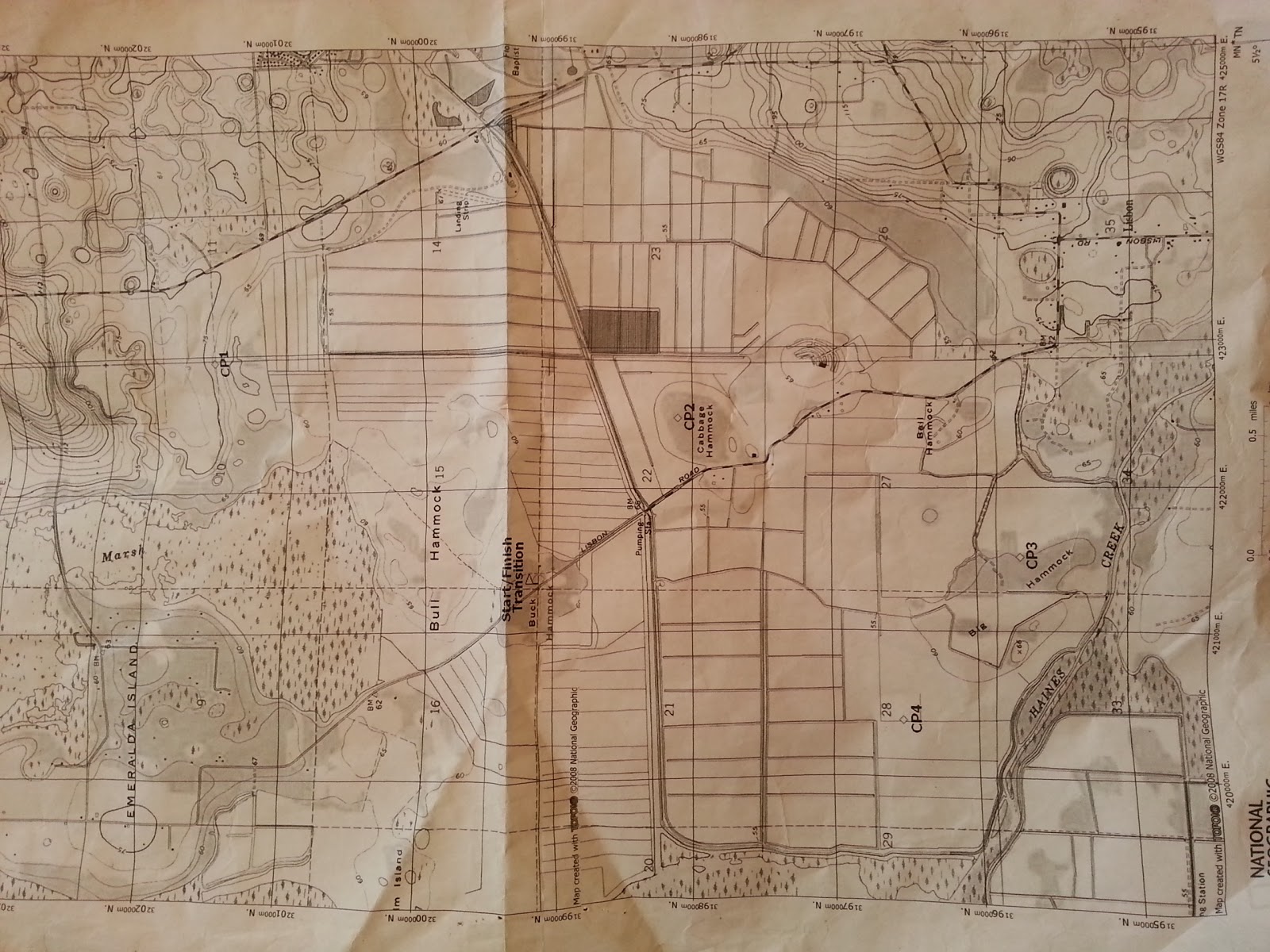
The trek map - not a lot of detail


Foggy picture - early CP


CP10 - Buddy's Memorial

CP4 - Observation Deck - LOTS OF BIRDS!

What is the Water Level?

Bike Map

House on Stilts - strange

Does it really flood that bad?


Mark at Finish Line - full map


CP12 !

Damn - No Shade

Junos at CP10

Eagle's Nest


Our instructions

Found another CP


Monday, July 15, 2013

Luminescent Adventure Race 2013

About twice a year Dave Brault and I get team Not Lost, Just Resting together to see how two 50 year old guys can race. I have a fondness for the Luminescent for 2 reasons, it is a night race and every now and then you get some brilliant light shows. Night adds an entirely new dimension to racing - and I always like trying out my night gear.

We started with an orienteering leg that took us in a loop around the eastern areas of Salt Lake WMA. The top teams moved through this as a group in about 40-45 minutes and we headed out on the bike leg to the boats about 30 seconds behind Team Jax and just in front of Mojitos on Monday. We got into a tight bike line with Dave Shuman setting a great pace, however they turned at War Admiral which was not my race strategy - that was the last we would see of them in a while. We hit the bike checkpoints with Team Jax, and because of a last minute wrong turn by them came into the TA literally 30 seconds in front of them.


The paddle was really nice. Greg had asked us to place glowsticks on the northern controls for the sport teams - so we headed south first. This worked out well as Team Jax and our team went south first and most of the other teams wen north first. This meant that the elite teams were able to visit the controls pre-glowstick while the slower teams and the sport teams got the benefit of the glowsticks. We and Team Jax were never more than 2 minutes apart this entire paddle and the only minor error we made was not seeing the entrance as we left CP3 (on south island) and headed to CP4. This had us doing a little curve backwards to get CP4.

The bike back was completely uneventful, we rode by the school and found the clue War Eagles without slowing down for our last CP. The next leg was a choice of bike or trek - we chose to bike since we were in our bike shoes and ready to go. Jax had a 2 minute lead out the TA, but we caught them at the second control. We worked together through the next couple of controls until we got to CP19. They found this one quickly and headed on. We missed it by about 20 yards on our first attack and ended up spending about 15 minutes searching. I figured out our best attack at about the same time Team Mojitos came by the CP - we found it and then were on to CP20. On the way to CP20 we ran into Team Jax coming back towards us. This made no sense since they there were no controls back that way. They had not found CP20 yet - but had scoured the bike trails. This helped me decide on a conservative approach to CP20. We stopped at a T-Intersection south of the control and took a bearing through a nice deep swamp - that took us right to the CP.  Team Mojitos - who had been with us at CP19 had taken a different turn on the way to CP20. As we got back to the bikes after our swamp whack to CP20 - we ran into Mojitos again. We stayed with Jax working together to finish the bike leg.


The last leg was a trek and looked pretty challenging. We had no issues with any of the navigation and lightly jogged most of this. We came up behin Team Jax at the last control and simply jogged behind them to the finish line - avoiding a last minute sprint to the finish. It was really good to work with them and they ran a great race.

Results at http://pangeaadventureracing.com/event-details/events/2013-luminescent-ar

Great pictures at https://www.facebook.com/pangeaadventureracing 

 Also - new gear recommendation. I tried the Cree 3600 lumen light cannon. For less than $40 this light puts out a ton of light and can be easily used on the bike or as a headlamp. I recommend it -

SecurityIng 3800 Lumen Headlight


Sunday, June 16, 2013

SCAR Adventure Race

The SCAR is one of those great annual races, and it usually hot. I heard from Erik with Mojitos on Monday (Jeanette Ciesla, Dave Shuman, Erik Wise) - and was in and racing!

This race had some very challenging navigation, especially on the paddle. Most of the checkpoints along the paddle were down side channels - meaning we would have to pay very close attention to our navigation. I also have previous experience in the Wekiva river - meaning I know how many side channels and tricky navigation spots there are. Our strategy was to head upriver passing CP8 and CP7 (by the marina) - and hit all of the CP's on the way to CP1 and CP2 - which I was sure would be pretty challenging. The aerial shots of the area near CP1 and CP2 show that the intersection where the split is more of a T. When we reached the intersection I was a bit confused as I did not see a channel curving north after the jog east. We looked around and eventually realized that we simply had to bash through a little tree cover to get through. After that we had little trouble finding CP2 since it was visible from the main channel.

Knowing the location of CP2 made it really easy to find CP1 - since now i was sure of the location of the T intersection. On the way back we snagged CP7 and CP8.

The trick to this navigation was keeping meticulous track of your location along the river at all times. I made sure I viualized our boat as a little dot along the blue line of the river. I also called out left 90, right 180, etc... as I anticipated turns in the river so both boats (Erik and Dave in the other boat) could anticipate each turn.


We were the 2nd team off the water with Canyoneeros. We don't know who the first team was or if they got all the points. We had a few teams with us at CP1 and CP2, but did not see any of them around.

Here is the detailed track of the area around CP1 and CP2.


The trek was pretty straightforward and we finished in about 1hr. There was a little issue with overheating. It was nice of Greg to put ice in a nice central location - and we definitely appreciated it.

The next section was the bike/trek. The bike leg was challenging, though still hot. The real challenge came after we dropped the bikes at CP15. The section north of CP15 was a foot section (you could bring bikes, but with the vegetation - you would not have wanted to). The video shows some of the ineresting parts of this trek.


Here you can see my strategy on CP24. We aimed off to the north since we knew we could use the ditch (description was at end of ditch from Northeast). Then I headed south to the ditch and southwest to the end.CP25 we kept a solid direct bearing. We had dropped the bikes north of CP15 to avoid the thick palmettos, so the route away from CP25 headed northwest.


Results are at http://pangeaadventureracing.com/event-details/events/2013-scar-ar  

Monday, May 20, 2013

Atomic Adventure Race 2013

This is one of my favorite races - the team was Caryn Ciesla (in her first race over 30 hours), Rick Holley, and Junos Reed.


Trek CP1-CP9

We were bussed from the parking area at Blue Ridge Lake to the actual start location. The remote start was a really cool working mill. The first few controls were easy trail and woods running. We ran into our first challenge at CP3. We went up the trail past a road intersection (as show on map). I was suspicious as the map show the trail heading in a different direction than the trail actually went. We followed it for the correct distance and then attacked where we thought the control would be.  quickly realized (which I should have done from before) that the trail was drawn in by hand and did not actually match reality. We bailed to the road, re-attacked it from road - and found it quickly. At the same time we also pointed it out to the half dozen or so teams looking for it.

The next few controls went pretty easy, until we got to CP8. CP7 was a nasty climb up a hillside and then the easy route was to bomb down the hillside and attack 8 from below. We decided to use a road that was mapped, but not completely. The road took us right above 8 and we headed down, but after some searching did not find it an then bailed out. My tracker later confirmed we were literally on top of it - but did not see it, but that sometimes happens (even though the woods there were quite open). We had pretty much figured that the course could not be cleared in 30 hours - so the plan was not to waste too much time if we were stuck.

Paddle CP10-CP12

The next leg was a paddle down the Toccoa River with a few controls for good measure. Caryn was going to get to do rapids for the first time in a canoe. I had no plans of going in the water - and she was hilarious after our first little whitewater - about a 1 foot drop over a ledge. She yelped, held her paddle in the air, and nearly leaped out of the boat. A few more rapids an she was gaining confidence and starting to enjoy the bumps.

Just after shooting the rapids near the swinging bridge we had a complex rapid that I had lined up to cross from right to left to right to run. We dropped through 2 hydraulics and she started sliding in her seat as I was twisting the boat hard to make the turns. We started to tip left and I correct hard right, she slipped hard left in her seat,grabbed the right gunnel (as whitewater paddlers will know - that is the kiss of death) and pulled the boat over.

The water was pretty cold, but we had left the worst of the rapids, so I had no problem grabbing her, attaching her to the boat, grabbing the paddles which I had put floaties on in case we tipped, and swimming the boat to the right shore. Junos swam out to help me (actually he could have cared less about me, he swam out to help Caryn) get the boat to shore. We dumped the water - all the gear was in dry bags and attached - so we hopped in and headed downstream.

We got all the checkpoints along the paddle, they were fairly easy, though they were not visible from shore. Caryn was a little cautious after tipping, though she did just fine. She had done quite well considering it was her first time paddling in rapids.

 Bike CP13-CP20 an CP21-CP23

The next leg was a bike, which was nice and relatively flat. The course took us to the Stanley TA which was a good distance. From there teams would put on wrist-bands and do the last three bike points having all members punch their bands. Good plan as this entailed a lot climbing (all the climbing we had avoided in the first part was bunched into this part). Caryn had struggled a bit on the first bike leg - and I decided that we would skip these 3 points (21,22, and 23).

Long Trek CP24-CP29

This next leg was the one that would decide the fate of most teams. This was a night trek with challenging navigation. There was a continuous threat of rain and it had been raining (but not hard) off and on during the day. We started well heading to CP32 first. After CP31 I decided we would go for the tough control - CP26. We had been warned in pre-race this was a challenging control and only a fraction of the teams that attempted it, got it. After about 90 minutes of searching in incredibly thick brush, on a very steep rocky hillside - I finally called it quits. Before I did, I found an old cross trail that took me over the spur to the next re-entrant east. I went over and then back (which was relatively easy since I had found the old trail) - I almost decided to give it another try (which would have meant climbing back up the steep rocky re-entrant) - but decided to save my energy for a later control.

Here is the track from my tracker:


After this we headed out to CP30 which was pretty easy. We skipped CP27 - and headed back to do CP29, CP24, and CP25. We chose to do CP29 first - this one was pretty easy, but the trail was a lot longer than it appeared to be on the map - as the mapper had chosen to cut out nearly all of the odd bends and switchbacks on the trail. Once we got back to the base of the trailhead at CP29 - we decided to head in. It was starting to rain pretty hard, and Junos was bleeding on his thighs from friction rub from walking in wet pants. Caryn was having some bad knee pain and they did look swollen. Junos was worried about his ability to finish. As we approached the Stanley TA the skies started to open up and give us some intense rain. I decided to rest the team and that we would head out after daylight (6:30 AM) - it was currently 4:30. I was a bit anxious at first as I really wanted to snag CP24 and CP25, but pushing the team too hard here would have potentially been race ending.

After a bit of rest and daylight - the team was in much better spirits and were ready to bike back to the main TA. It was still raining, hard at times - but we had a feeling the weather would break soon. The downhills were pretty sloppy - especially on Aska Road - kicking up a rooster tail (in your own face) at 30 mph.

Once in the main TA, we had 12 checkpoints that we had to transfer from a master map, onto our map - and then essentially paddle and trek to visit. They all looked pretty easy (and they were) except that I copied one down wrong off the master map - and had to go back (with the entire team) to the Main TA to recopy. luckily it was not one that was far away. Many teams at this point had had enough dealing with rain and cold - and the 12 checkpoints were good enough to put us in 6th place.


Caryn had completed her first long (and overnight) race. They team overcame a lot of problems that could have stopped us. But we pushed through and did quite well. Here is a little video of some scenes from the adventure:


Monday, May 06, 2013

Florida Orienteering

The orienteering event this weekend was quite fun, helped by cloud cover and some cooler weather. I shot a little bit of video as I was using this as a practice run for the Atomic May 18 - check out the baby fox at 3:15 in the video. This was shot in HD - so if you change the video quality it is easier to see everything.

Sunday, April 21, 2013

Doing the Dixie Conquest - Team Honey Stinger

Well - sometimes races go great an sometimes not. This ended up being a very tough race for us. we had a string of errors that were recoverable and one that was not. The team was Jim Gorton, Courtney Spratt, Junos Reed and myself.

We started with a short orienteering run and quickly established a lead by burning through it in 27 minutes an getting out of the transition to bike very quickly. Our first mistake came with hitting Bayard Road and me going the wrong way because I never looked at the North Arrow on the map. I realized the mistake and we made it out to the paved road and tucked into a bike line and literally flew down the road - but we lost about 15 minutes on this mistake.

At the boats we decided to head south first and picked up the points pretty easily. CP10 was a really cool spot at the end of a small creek shown here. The remaining controls were straightforward - and also led to a lot of jokes about big root balls (clue one CP).


Heading back north to CP8 the frontal system that had been coming in turned into an all out gale which gave us some pretty challenging paddling. Waves were cresting at about 2 feet, but the wind (and cold) was the real issue and it really slowed our pace down as we headed to CP8. I had figured since we passed a lot of boats that we could get CP8 and be back with the lead pack as we left the boats. This was not going to be the case.

The hard rain and surprisingly cold temps had me shivering quite a bit as we came out of the boats at CP8. We attacked CP8 a little south of the control, but checked the direct location (with 3 of us scouring the area) very well. After that we simply searched further and further from the mapped location. I even went in the duckweed covered canal (about waist deep) to see if I could get a better vantage on the control. No luck in finding the control even had me doubting our overall location we did a little northern leg just to be sure. Since we had been told at pre-race the course would be hard to clear - we licked our wounds and bailed on the control.


The bike ride back had a few CP's. There was a 2 CP bikewhack that we went around, but found from some of the riding, the bikewhack would have been better. The only control to give us issues was CP16 due to a parallel unmapped trail. From the footprints on this one - we were not the only ones to have an issue with this. We again realized our mistake and corrected - had I measured the maps (we were given these on the fly) I would have realized the mistake and hit the correct trail. Also this is one spot where a little familiarity with the park would have been useful.


We made it back to the main TA where we picked up our next set of bike controls, and also our shoes for the second trek. On the way to the trek we stopped for the tower  challenge. This was pretty fun - I was in the tower calling out bearings to my three team-mates while guiding them to the control that I could see from the tower - but they could not see from the ground. If Jeff posts some video of this - I'll put a link here - some of the teams were hilarious.

When we got to the foot section I calculated that we would be able to finish the race with a solid hour to spare. We moved pretty well through the foot controls though there were some challenging ones - especially CP22 which had a drawn trail that did not match the actual trail.

Here are some highlights from this section - one nav error - when we left CP18 I did not recognize the trail leading to CP19 so ended up going to the sand pile to re-orient. The battery in my tracker gave out just before CP23 (it only lasts 8 hours) - but you can see that we were on the right track there.


Here are a couple of video clips I took on the trek;


In the end the missed CP8 bumped us to 9th place. Team Jax carried the day with an excellent performance. Results are at http://pangeaadventureracing.com/event-details/events/2013-dixie-conquest-ar

If you want to see our team Track it is here http://connect.garmin.com/activity/300953734#.UXPtdem68BE.email

Wednesday, March 06, 2013

Guide to Your First Pangea Adventure Race

 
So you would like to come out and do your first adventure race. This is a little step by step guide that will make your experience a fantastic one. This will take you through what to expect in your first race and what to do to prepare for it.

1. Find a buddy - Adventure racing is a team sport, and team can be anywhere from 2 to 4 persons. For your first race it is best to have a like minded buddy that wants to head out and have a great time. If possible your partner should have a similar level of fitness, though this is not necessary.


2. Get some gear - You won't need a lot of gear for your first race. You will need a bike and helmet (mountain bike is definitely best), a pack, something to hold liquids, and the mandatory gear (whistle, compass).
  
If you have these two things - then it is time to sign up for your first race. If you have not done an adventure race you should sign up for the sport class race. Many very solid athletes decide that they are ready for elite in their first race - they aren't. Sport races are a bit shorter (3-4 hours) than elite, and the terrain and navigation will be easier than you will face in an elite class race. Just trust me here.

About the race

So now you have signed up for the race and it is a 3 hour race. Adventure Races are typically (but not always) measured in time. The race will involve visiting as many check points (orange flags) as you can within a time limit (the race length). You will visit some of these on foot, some on bike, and some by boat. The locations of these will be on a map given to you at the race start, and you will have written instructions describing the locations too. Each checkpoint has a coded punch that you will use to punch a punch card that proves that you visited the point.


When you arrive at the race site you will want to set up your gear in the transition area. Some team will have very elaborate setups with tents, bike racks, tables - and some teams will simply show up and drop their bikes on the ground. You will drop off your gear and then check in and get your maps. For most races you will also be assigned a starting discipline; bike, foot, or paddle. This keeps teams separated and also makes sure that all teams have boats when they get to the paddle. You will also usually have about an hour to plan your race, and also before every sport race Pangea holds an Adventure Racing 101 to help you know what to do.


The Race

At the allotted time the race will start and all the teams will head off in different direction on their assigned discipline. As you go through the course you will punch your passport and usually come back to the transition area for a punch card for your next discipline. You will want to manage your time - the time limit is a hard limit and after the time expires you will be assessed point penalties. That is pretty much how the race works, but of course there will be all kinds of strategies, some transitions from discipline to discipline, and a lot of fun.


The Scoring

So how is this scored. Unlike most races, this one is about collecting as many points as possible within the time limit. Going over the time limit will cost you points. The team that gets the most points wins the race. In case of a tie the team that got the points in the fastest time wins. It is actually quite simple. As you get better at racing, the first goal is to "Clear the Course", this is visiting all the control points inside the time limit.


Moving Up

A laudable goal for adventure racing is to clear an elite course. Typically a race is designed so that only 3-5 teams will be able to clear the course. This keeps the format fresh in that there is always a challenge.


Further Challenges

One of the beauty of adventure racing is that the challenge really never ends. There are always longer and harder races out there. There is always more extreme terrain to explore - the adventure never really ends... (here are some scenes you will not see on a mud run...)


learn more at http://en.wikipedia.org/wiki/Adventure_racing